Kanektok River

Last updated
Kanektok River
Togiak Refuge (12293842965).jpg
The Kanektok River flows through the Togiak National Wildlife Refuge.
Relief map of USA Alaska.png
Red pog.svg
Location of the mouth of the Kanektok River in Alaska
Location
Country United States
State Alaska
Census Area Bethel
Physical characteristics
SourceKagati Lake
 - location Togiak National Wildlife Refuge
 - coordinates 59°52′48″N160°07′25″W / 59.88000°N 160.12361°W / 59.88000; -160.12361 [1]
 - elevation1,059 ft (323 m) [2]
Mouth Kuskokwim Bay
 - location1.5 miles (2.4 km) west of Quinhagak
 - coordinates 59°44′46″N161°55′53″W / 59.74611°N 161.93139°W / 59.74611; -161.93139 Coordinates: 59°44′46″N161°55′53″W / 59.74611°N 161.93139°W / 59.74611; -161.93139 [1]
 - elevation0 ft (0 m) [1]
Length75 mi (121 km) [3]
Basin features
Basin size752 sq mi (1,950 km2) [4]

The Kanektok River is a 75-mile (121 km) stream in southwestern Alaska in the United States. [3] Beginning in the Ahklun Mountains at Kagati and Pegati lakes, it flows westward into Kuskokwim Bay on the Bering Sea at the city of Quinhagak. [5] Almost all of the river's course lies within the Togiak National Wildlife Refuge. [5] The Quinhagak Village Corporation owns the land bordering the lowermost 17 miles (27 km) of the river. [6]

Alaska State of the United States of America

Alaska is a U.S. state in the northwest extremity of North America, just across the Bering Strait from Asia. The Canadian province of British Columbia and territory of Yukon border the state to the east and southeast. Its most extreme western part is Attu Island, and it has a maritime border with Russia to the west across the Bering Strait. To the north are the Chukchi and Beaufort seas—southern parts of the Arctic Ocean. The Pacific Ocean lies to the south and southwest. It is the largest U.S. state by area and the seventh largest subnational division in the world. In addition, it is the 3rd least populous and the most sparsely populated of the 50 United States; nevertheless, it is by far the most populous territory located mostly north of the 60th parallel in North America: its population—estimated at 738,432 by the United States Census Bureau in 2015— is more than quadruple the combined populations of Northern Canada and Greenland. Approximately half of Alaska's residents live within the Anchorage metropolitan area. Alaska's economy is dominated by the fishing, natural gas, and oil industries, resources which it has in abundance. Military bases and tourism are also a significant part of the economy.

Ahklun Mountains mountain in United States of America

The Ahklun Mountains are located in the northeast section of the Togiak National Wildlife Refuge in southwest Alaska. They extend southwest from the Kanektok and Narogurum Rivers to Hagemeister Strait and Kuskokwim Bay and support the only existing glaciers in western Alaska. They are the highest Alaskan mountain range west of the Alaska Range and north of the Alaska Peninsula: some summits in the range have many glaciers. To the west is the Kuskokwim River and to the east are the Bristol Bay lowlands.

Kuskokwim Bay

Kuskokwim Bay is a bay in southwestern Alaska, at about 59°30′N162°30′W. It is about 160 km (99 mi) long, and 160 km (99 mi) wide.

Contents

Recreation

The Kanektok River, varying from Class I (easy) to II (medium) on the International Scale of River Difficulty, is floatable by many kinds of watercraft. The upper reaches below Kagati Lake are sometimes too shallow for boats. Below this, swift currents, braided channels, logjams, and overhanging or submerged vegetation make the float "not a trip for beginners." [4] In high water, the difficulty along the upper 55 miles (89 km) of the river may increase to Class III (difficult). [4]

Alaska Fishing describes the river as "one of Alaska's most celebrated salmon and trout streams". [6] The main game fish are rainbow trout, char, Arctic grayling, king (Chinook), silver (Coho), chum, and red (sockeye) salmon. Anglers can float down from the headwaters , hire a boat to go upriver from Quinhagak, or fish near tent camps and lodges along the lower river. [6]

Game fish fish hunted for sport or food

Game fish are fish pursued by recreational anglers. They can be freshwater or saltwater fish. Game fish can be eaten after being caught. Some game fish are also targeted commercially, particularly salmon.

Rainbow trout species of trout

The rainbow trout is a trout and species of salmonid native to cold-water tributaries of the Pacific Ocean in Asia and North America. The steelhead is an anadromous (sea-run) form of the coastal rainbow trout(O. m. irideus) or Columbia River redband trout (O. m. gairdneri) that usually returns to fresh water to spawn after living two to three years in the ocean. Freshwater forms that have been introduced into the Great Lakes and migrate into tributaries to spawn are also called steelhead.

<i>Salvelinus</i> genus of fishes

Salvelinus is a genus of salmonid fish often called char or charr; some species are called "trout". Salvelinus is a member of the subfamily Salmoninae within the family Salmonidae. The genus has a northern circumpolar distribution, and most of its members are typically cold-water fish that primarily inhabit fresh waters. Many species also migrate to the sea.

See also

Related Research Articles

Chena River river in Alaska

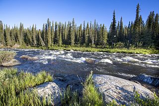
The Chena River is a 100-mile (160 km) tributary of the Tanana River in the Interior region of the U.S. state of Alaska. It flows generally west from the White Mountains to the Tanana River near the city of Fairbanks, which is built on both sides of the river. The Tanana empties into the 2,300-mile (3,700 km) long Yukon River.

Delta River river in the United States of America

The Delta River is an 80-mile (130 km) tributary of the Tanana River in the U.S. state of Alaska. Its name in the Ahtna language is Saas Na’ . Fed by the Tangle Lakes of the Alaska Range, the river flows north to meet the larger river near Big Delta.

Karluk River river in the United States of America

The Karluk River is a stream, 24 miles (39 km) long, on Kodiak Island in the U.S. state of Alaska. It begins at Karluk Lake in the Kodiak National Wildlife Refuge and flows north and then northwest through Karluk Lagoon to the Shelikof Strait at Karluk.

Kenai River river in the United States of America

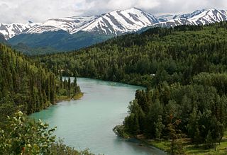
The Kenai River called Kahtnu in the Dena'ina language, is the longest river in the Kenai Peninsula of south central Alaska. It runs 82 miles (132 km) westward from Kenai Lake in the Kenai Mountains, through the Kenai National Wildlife Refuge and Skilak Lake to its outlet into the Cook Inlet of the Pacific Ocean near Kenai and Soldotna.

Swanson River river in the United States of America

The Swanson River is a stream, 40 miles (64 km) long, on the Kenai Peninsula of south-central Alaska in the United States. Beginning at Gene Lake in the Swanson Lakes district, it flows southwest then north to Number Three Bay on the Gompertz Channel of Cook Inlet.

Chitina River river in the United States of America

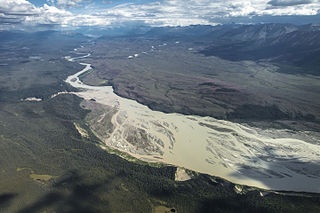
The Chitina River is a 112-mile (180 km) tributary of the Copper River in the U.S. state of Alaska. It begins in the Saint Elias Mountains at the base of Chitana Glacier and flows generally northwest through the Wrangell–St. Elias National Park and Preserve to meet the larger river near Chitina. The watershed was once a major copper mining region.

Newhalen River river in the United States of America

The Newhalen River is a 22-mile (35 km) stream in the Lake and Peninsula Borough of the U.S. state of Alaska. Beginning at Six Mile Lake, the Newhalen flows south to enter Iliamna Lake about 3 miles (5 km) south of Iliamna.

Aniak River river in the United States of America

The Aniak River is a 95-mile (153 km) tributary of the Kuskokwim River in the U.S. state of Alaska. Beginning south of Aniak Lake, the river generally flows north. The upper sections drain part of the Kilbuck and Kuskokwim mountains, and the lower portions transition to the Kuskokwim lowlands and tundra. The river empties into the Kuskokwim River slightly east of Aniak.

Beaver Creek (Yukon River tributary) clear water river in Alaska

Beaver Creek is a 180-mile (290 km) tributary of the Yukon River in the U.S. state of Alaska. The creek begins at the confluence of Champion and Bear creeks in the White Mountains National Recreation Area, about 50 miles (80 km) north of Fairbanks. From there it flows west around the southern end of the White Mountains, then northeast into the Yukon Flats National Wildlife Refuge, then west into the Yukon River downstream of Beaver.

Chandalar River river in the United States of America

The Chandalar River is a 100-mile (160 km) tributary of the Yukon River in the U.S. state of Alaska. Its peak flow, recorded by the United States Geological Survey (USGS) between 1964 and 1974 at a stream gauge at Venetie, was 62,800 cubic feet per second (1,780 m3/s) on June 9, 1968.

Chilikadrotna River river in the United States of America

The Chilikadrotna River is a 55-mile (89 km) tributary of the Mulchatna River in the U.S. state of Alaska. It begins in Lake Clark National Park and Preserve in northern Lake and Peninsula Borough and flows westward into the larger river 46 miles (74 km) northwest of Nondalton.

Gulkana River watercourse

The Gulkana River is a 60-mile (97 km) tributary of the Copper River in the U.S. state of Alaska. Beginning near the southeastern end of Summit Lake in the Alaska Range, the river flows generally south to meet the larger river 9 miles (14 km) northeast of Glennallen. The Richardson Highway and the Trans-Alaska Pipeline run north–south, nearby and roughly parallel to the Gulkana River. Slightly south of Summit Lake the river passes under the east–west Denali Highway near its junction with the Richardson Highway at Paxson.

Mulchatna River watercourse

The Mulchatna River is a 160-mile (260 km) tributary of the Nushagak River in the U.S. state of Alaska. Beginning at Turquoise Lake, it flows generally southwest to meet the larger river 65 miles (105 km) northeast of Dillingham. The Mulchatna's mouth is slightly south (downstream) of the village of Koliganek on the Nushagak, which continues southwest to Nushagak Bay, an arm of Bristol Bay.

Togiak River river in the United States of America

Togiak River is a stream, 48-mile (77 km) long, in the southwestern part of the U.S. state of Alaska. It begins at Togiak Lake in the Togiak Wilderness and flows southwest to Togiak Bay, 2 miles (3.2 km) east of Togiak.

Tazlina River river in the United States of America

The Tazlina River is a 30-mile (48 km) tributary of the Copper River in the U.S. state of Alaska. Draining Tazlina Lake, it flows generally east to meet the larger river 7 miles (11 km) southeast of Glennallen.

Nuyakuk River river in the United States of America

The Nuyakuk River is a 36-mile (58 km) tributary of the Nushagak River in southwestern Alaska, United States. From its source at Tikchik Lake, an extension of Nuyakuk Lake in Wood-Tikchik State Park, it flows eastward into the larger river upstream of Koliganek. The Nuyakuk's mouth is 65 miles (105 km) northeast of Dillingham.

Tikchik River river in the United States of America

The Tikchik River is a stream, 45 miles (72 km) long, in the U.S. state of Alaska. Beginning at Nishlik Lake in the Kuskokwim Mountains, it flows southeast into Tikchik Lake, 65 miles (105 km) north of Dillingham. Tikchik Lake empties into the Nuyakuk River, a tributary of the Nushagak River, which flows to Nushagak Bay, an arm of Bristol Bay.

Eek River river in the United States of America

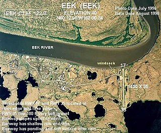
The Eek River is a 108-mile (174 km) tributary of the Kuskokwim River in the U.S. state of Alaska. It is south of the Kwethluk River and north of the Kanektok River, which also drain into the Kuskokwim or Kuskokwim Bay on the Bering Sea.

Chatanika River river in the United States of America

The Chatanika River is a 128-mile (206 km) tributary of the Tolovana River in the U.S. state of Alaska. The Chatanika River is a clear or lightly tannic stained rapid-runoff stream that has its headwaters in the mountains of the northeastern portion of the Alaska Range and flows westward through valleys between summits and uplands for about four-fifths of its length before it enters Minto Flats. Once in the flats—a marshy area in which multiple streams, rivers, and lakes are located— the Chatanika joins the Tolovana, which flows into the Tanana River and on to the Yukon River. The Chatanika is thus a portion of the Yukon River drainage basin.

Eagle River (Bradfield Canal) river in the United States of America

The Eagle River is a stream, 8 miles (13 km) long, in the borough of Wrangell in the U.S. state of Alaska. Heading at Eagle Lake in the Coast Mountains, it flows northwest through part of the Tongass National Forest into Eagle Bay on the Bradfield Canal. Near the midpoint of its course, the river passes through Little Eagle Lake. On the shore opposite Eagle Bay and the Eagle River mouth, the Harding River enters Bradfield Canal.

References

  1. 1 2 3 "Kanektok River". Geographic Names Information System. United States Geological Survey. March 31, 1981. Retrieved November 16, 2013.
  2. Derived by entering source coordinates in Google Earth.
  3. 1 2 Orth, Donald J.; United States Geological Survey (1971) [1967]. Dictionary of Alaska Place Names: Geological Survey Professional Paper 567 (PDF). University of Alaska Fairbanks. United States Government Printing Office. p. 493. Archived from the original (PDF) on October 17, 2013. Retrieved November 17, 2013.
  4. 1 2 3 Jettmar, Karen (2008) [1993]. The Alaska River Guide: Canoeing, Kayaking, and Rafting in the Last Frontier (3rd ed.). Birmingham, Alabama: Menasha Ridge Press. pp. 187&ndash, 88. ISBN   978-0-89732-957-6.
  5. 1 2 Alaska Atlas & Gazetteer (7th ed.). Yarmouth, Maine: DeLorme. 2010. pp. 54&ndash, 55. ISBN   978-0-89933-289-5.
  6. 1 2 3 Limeres, Rene; Pedersen, Gunnar; et al. (2005). Alaska Fishing: The Ultimate Angler's Guide (3rd ed.). Roseville, California: Publishers Design Group. p. 248. ISBN   1-929170-11-4.