Kangaroo Ground War Memorial Park

Last updated

Kangaroo Ground Tower of Remembrance Kangaroo Ground Tower of Remembrance.jpg
Kangaroo Ground Tower of Remembrance

Kangaroo Ground War Memorial Park is located at 385 Eltham Yarra Glen Road, Kangaroo Ground in the Shire of Nillumbik. [1] in Victoria, Australia. The site includes the war memorial, with a firespotting cabin, mature monterey cypress trees and other planted species, and a sandstone caretaker's cottage. [1] The park is situated on the summit of Garden Hill, from which panoramic views are obtainable. [2] The park is situated on two acres. [3]

Contents

Towards the end of World War One, in August 1918, Eltham Shire Council discussed and 'generally expressed themselves as favourable to the proposal' to obtain a "piece of land on the summit of Garden Hill, Kangaroo Ground, and the formation of a memorial park in which a monument could be erected to represent the whole of the Shire. [4] Local resident Walter Wippell donated £50 and with it Council purchased the one-acre site. [3] In 1919 Joseph Mess agreed to take £50 per acre for two acres of his Garden Hill property. [5] By 1920 subscriptions lists were opened for the purposes of raising funds to "carry out the proposed scheme of beautification, and also to erect, at a later date, a fitting monument to perpetuate the memory of those who fell in the Great War'. [6]  Working bees took place on the site and rocks were collected for a memorial cairn which was built in a slight depression which signified the highest point in the park. [3] The compilation of "a complete record of the names of all persons who enlised for service from the Shire and of those who made the supreme sacrifice whilst doing their duty" began in 1920. [6] The park was officially opened by Mr. W. H. Everard, M.L.A. on 3 September 1921. [2] In 1927 a stone hut, known as the caretaker's cottage was built from left over stone quarried for the tower. [3] On Remembrance Day, 2005 a seedling, a descendant of the Gallipoli lone pine tree was planted. Brick toilets constructed in 1965 were also removed and replaced in 2005 including a universal access space. [3]

In 2006, a plaque was put in place from the Vietnam Veterans community in commemoration of the 40th anniversary of the Battle of Long Tan. [7] Nillumbik Shire Council received funding under the 2008–09 Restoring Community War Memorials Grants program to restore plaques on the Tower, and replace bollards to enhance security around the memorial. [8] In December 2014, Nillumbik Shire Council received Anzac Centenary Local Grants Program funding to create new interpretative signage. [9]

In 2015 Shire of Nillumbik added the Tower of Remembrance and War Memorial Park and Moor-ul Viewing Platform to its draft register of memorials. [10] In 2020 Shire of Nillumbik commenced preparing a master plan to create a long-term vision and plan for the park. [11]

Geology

Garden Hill and the surrounding 2000 acres consisting of black soil are probably the remains of an extensive sheet of lava that once flowed down a shallow river valley. Possibly there were two flows. Early settlers considered the area an extinct volcano. [12]

Shire of Eltham War Memorial

The Shire memorial [13] was built based on a sketch by artist Harold Herbert who was inspired by the view, which reminded him of northern England and a conversation with friend Basil Hay mentioning stone keeps built to detect cattle duffing raids centuries ago on the border counties of Scotland and England. [14] It was designed by architects Stephenson and Meldrum. [1] (Later known as Stephenson and Turner). It is built from local stone donated by the local community including Professor William Osborne, [1] [15] and reinforced concrete with sandstone rubble facing and concrete quoins and dressings. The foundations are solid rock with the base of the tower in 16 x 16 external and 11 x 11 internal, the wall being 2 feet 6 inches thick at the base, tapering to 16 inches at the top. The building contractor was George Rousell. [16] The original internal staircase was made from jarrah, with galvanised iron pipe handrailings [16] leading to a look-out. There are 53 stairs. [17] The memorial is 40 feet high [13] or 237 metres. [18]

The view extends to the Kinglake National Park escarpment, the mountains beyond Healesville, the Dandenongs, Port Phillip Bay, the You Yangs and Mt. Macedon. [18]

It was opened on Armistice Day, 11 November 1926, by the governor-general, Lord John Baird Stonehaven, when he also unveiled a temporary honour board. [1] [19] In 1930 a tablet bearing the names of men who served and fell in the First World War was erected on the memorial. [20] On 16 November 1951, the governor of Victoria, Sir Dallas Brooks re-dedicated the memorial with an additional plaque to honour those who had died between 1939 and 1945 [18] and the caretaker's cottage as memorials to the dead of the two world wars. [21] In November 2001, on the memorial's 75th anniversary, Victorian Governor John Landy unveiled plaques to honour servicemen and women who served in post World War 2 conflicts in Korea, Malaya, Borneo and Vietnam. [22]

The memorial is considered architecturally, socially, aesthetically and historically significant to the Shire of Nillumbik and is considered one of Victoria's most unusual war memorials. [1]

Fire Spotting

Following the Black Friday Bushfires in 1939, which impacted the area, [23] a telephone was installed for the use of volunteers using the tower as an observation post for fires. [24] Forests Commission Victoria included the tower as part of its fire-watching network and it was the command post when significant bushfires took place locally in 1962. [14] An enclosed cabin cover was erected on the top of the tower in 1974. The advice of Mr Meldrum, the architect of the memorial was sought and he agreed that the proposed shelter could be added without aesthetic damage. [25] On Black Saturday, 7 February 2009, fire spotters observed new fires starting and with the help of maps, binoculars and other towers in the region, they were able to determine the location of fires starting up, which were then reported to the Kilmore incident control centre. [26] This cabin was replaced with a new tower in December 2009. [27] Improvements included a new larger and airconditioned cabin two metres higher than the original cabin. It is fitted with new communication and mapping equipment and is built on a tilt to eliminate reflection. [28] It is a manned incident control centre in the summer, part of the Country Fire Authority's District 13 operations. [29]

Viewing Platform and Grasslands

The Moor-rul viewing platform was opened on 17 April 2008 in the presence of Jenny Macklin, MP. The function of the platform is to provide shelter adjacent to the war memorial whilst allowing people to enjoy the view. It can be accessed by wheelchair. The name Moor-rul is indigenous describing the fertile soils of the Kangaroo Ground area. Eight double-sided interpretative panels on the platform describe the Aboriginal and European history, geology and flora and fauna of the area. A small section of land next to the platform is maintained with plants indigenous to the area. [17]

Related Research Articles

<span class="mw-page-title-main">Shire of Nillumbik</span> Local government area in Victoria, Australia

The Shire of Nillumbik is a local government area in Victoria, Australia. It contains outer northern suburbs of Melbourne and rural localities beyond the urban area. It has an area of 432 square kilometres and at the 2021 census, the Shire had a population of 62,895. It was formed in 1994 from the merger of parts of the Shires of Eltham, Diamond Valley, Healesville and the City of Whittlesea. The Shire uses the tag-line The Green Wedge Shire. The Nillumbik Council offices are located in Civic Drive, Greensborough.

<span class="mw-page-title-main">City of Banyule</span> Local government area in Victoria, Australia

The City of Banyule is a local government area in Victoria, Australia in the north-eastern suburbs of Melbourne. It was created under the Local Government Act 1989 and established in 1994 as an amalgamation of former councils. It has an area of 63 square kilometres (24.3 sq mi) and lies between 7 and 21 km from central Melbourne. In 1994 it had a population of 116,000. In June 2018 Banyule had a population of 130,237. The Yarra River runs along the City's southern border while its western border is defined by Darebin Creek.

<span class="mw-page-title-main">Eltham, Victoria</span> Suburb of Melbourne, Victoria, Australia

Eltham is a suburb of Melbourne, Victoria, Australia, 20 km north-east of the Central Business District, located within the Shire of Nillumbik local government area. Eltham recorded a population of 18,847 at the 2021 census.

<span class="mw-page-title-main">Greensborough, Victoria</span> Suburb of Melbourne, Victoria, Australia

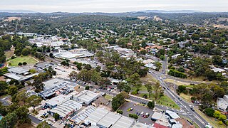
Greensborough is a suburb of Melbourne, Victoria, Australia, 17 km (11 mi) north-east from Melbourne's Central Business District, located within the City of Banyule and Shire of Nillumbik local government areas. Greensborough recorded a population of 21,070 at the 2021 census.

Christmas Hills is a town in Victoria, Australia, 35 km north-east of Melbourne's Central Business District, located within the Shire of Nillumbik local government area. Christmas Hills recorded a population of 365 at the 2021 census.

<span class="mw-page-title-main">Cottles Bridge, Victoria</span> Town in Victoria, Australia

Cottles Bridge is a town in Victoria, Australia, 30 km north-east of Melbourne's Central Business District, located within the Shire of Nillumbik local government area. Cottles Bridge recorded a population of 609 at the 2021 census.

<span class="mw-page-title-main">Diamond Creek, Victoria</span> Suburb of Melbourne, Victoria, Australia

Diamond Creek is a suburb of Melbourne, Victoria, Australia, 23 km north-east of Melbourne's Central Business District, located within the Shire of Nillumbik local government area. Diamond Creek recorded a population of 12,503 at the 2021 census.

<span class="mw-page-title-main">Hurstbridge, Victoria</span> Town in Victoria, Australia

Hurstbridge is a town in Victoria, Australia, 28 km north-east of Melbourne's Central Business District, located within the Shire of Nillumbik local government area. Hurstbridge recorded a population of 3,554 at the 2021 census.

<span class="mw-page-title-main">Kangaroo Ground, Victoria</span> Town in Victoria, Australia

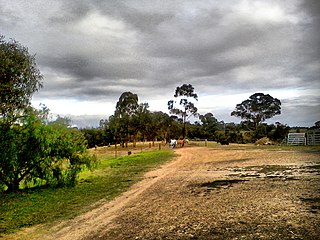
Kangaroo Ground is a town in Victoria, Australia, 26 km north-east of Melbourne's Central Business District, located within the Shire of Nillumbik local government area. Kangaroo Ground recorded a population of 1,208 at the 2021 census.

<span class="mw-page-title-main">Plenty, Victoria</span> Suburb of Melbourne, Victoria, Australia

Plenty is a suburb in Melbourne, Victoria, Australia, 21 km (13 mi) north-east of Melbourne's Central Business District, located within the Shire of Nillumbik local government area. Plenty recorded a population of 2,575 at the 2021 census.

Wattle Glen is a suburb of Melbourne, Victoria, Australia, 25 km north-east of Melbourne's Central Business District, located within the Shire of Nillumbik local government area. Wattle Glen recorded a population of 1,911 at the 2021 census.

<span class="mw-page-title-main">Yarrambat, Victoria</span> Town in Victoria, Australia

Yarrambat is a town in Victoria, Australia, 24 km north-east of Melbourne's Central Business District, located within the Shire of Nillumbik local government area. Yarrambat recorded a population of 1,602 at the 2021 census.

The Hurstbridge railway line is a commuter rail passenger train service in Melbourne, Australia. It shares tracks with the Mernda railway line until Clifton Hill, then heads in a north-east direction through the cities of Yarra, Darebin and Banyule, and the Shire of Nillumbik. It serves between Flinders Street in the Melbourne central business district through the northern suburbs up to Hurstbridge. The service is part of the Public Transport Victoria metropolitan rail network.

<span class="mw-page-title-main">Northern Football Netball League</span>

The Northern Football Netball League is an Australian sports league based in the Diamond Valley region of suburban Melbourne, Victoria. The league regulates competitions of both sports, Australian rules football and netball in the region.

Yarra Plenty Regional Library (YPRL) provides a public library service to the local government municipalities of the City of Banyule, Shire of Nillumbik and City of Whittlesea in the northeast of Melbourne Australia and located on the lands of the Woiworung. It is an independent legal entity with an executive management team which is responsible for day-to-day operations of the organisation. It is managed by the Yarra Plenty Regional Library Board made of two representatives (councillors) of the three municipalities that constitute the service. Its role is to set the policy and direction for the regional library service. The library service covers an area of 988.4 km² including metropolitan, urban fringe and rural populations. The organisation is administered from its Library Support Services (LSS) located at Daniher Drive, Sth Morang.YPRL also provides computer services to Murrindindi Library Service, including full access to the library's database.

Bend of Islands is a rural locality in Victoria, Australia, 30 km north-east of Melbourne's Central Business District, located within the Shire of Nillumbik local government area. Bend of Islands recorded a population of 267 at the 2021 census.

<span class="mw-page-title-main">Shire of Diamond Valley</span> Local government area in Victoria, Australia

The Shire of Diamond Valley was a local government area about 20 kilometres (12 mi) northeast of Melbourne, the state capital of Victoria, Australia. The shire covered an area of 74.38 square kilometres (28.72 sq mi), and existed from 1964 until 1994.

<span class="mw-page-title-main">Shire of Eltham</span> Local government area in Victoria, Australia

The Shire of Eltham was a local government area about 25 kilometres (16 mi) northeast of Melbourne, the state capital of Victoria, Australia. The shire covered an area of 277.13 square kilometres (107.0 sq mi), and existed from 1856 until 1994.

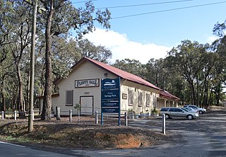
The Evelyn Observer was a weekly newspaper released from 1873 to 1942 in the north-east area of Melbourne, Victoria in Australia. It was first published on 31 October 1873 from a school house at Kangaroo Ground. Andrew Ross, the district's first school master and hotel-keeper was the Observer's first proprietor, and he enlisted the help of a printer, John Rossiter, who became the first editor. It then operated out of a dedicated building on the top of a hill. After the transfer of the newspaper office to Hurstbridge, the building was purchased by the Eltham Shire Council.

Eltham District Historical Society is a community organisation devoted to the collection, preservation and sharing of stories about the local history of the Eltham district in the north east of Melbourne, Victoria, Australia. Its geographic area of interest extends from Lower Plenty and Montmorency to Kangaroo Ground. It also maintains an interest in the former Shire of Eltham and holds memorabilia from the former Eltham Shire Council. It is located in the Shire of Nillumbik local government area. It also encourages conservation of significant places, spaces and documents for future generations. It is an affiliated member of the Royal Historical Society of Victoria and the Association of Eastern Historical Societies. It is an historical society managed by volunteers.

References

  1. 1 2 3 4 5 6 "Kangaroo Ground War Memorial Tower". Victorian Heritage Database. 5 January 2010.
  2. 1 2 "Eitham Shire Memorial Park". Argus (Melbourne, Vic. : 1848 - 1957). 6 September 1921. p. 3. Retrieved 14 May 2020.
  3. 1 2 3 4 5 Gilham, Harry (2002). The Tower of Remembrance and War Memorial Park on Garden Hill at Kangaroo Ground, Victoria, 1919-2001. Eltham District Historical Society. Eltham, Vic.: Eltham District Historical Society. ISBN   0-9577198-2-5. OCLC   223346984.
  4. "Eltham Shire Council". Eltham and Whittlesea Shires Advertiser and Diamond Creek Valley Advocate (Vic. : 1917 - 1922). 9 August 1918. p. 3. Retrieved 14 May 2020.
  5. "Ordinary Monthly Meeting". Eltham and Whittlesea Shires Advertiser and Diamond Creek Valley Advocate (Vic. : 1917 - 1922). 10 January 1919. p. 3. Retrieved 19 May 2020.
  6. 1 2 "Kangaroo Ground". Eltham and Whittlesea Shires Advertiser and Diamond Creek Valley Advocate (Vic. : 1917 - 1922). 21 May 1920. p. 2. Retrieved 14 May 2020.
  7. "Photograph - Plaque: Shire of Nillumbik World War One Memorials tour, 10 August 2016 - Victorian Collections". Victorian Collections. 7 June 2020. Retrieved 7 June 2020.
  8. "Restoring Community War Memorials 2008-09 Grant Recipients" (PDF). Trove. Archived from the original (PDF) on 23 October 2009. Retrieved 26 August 2020.
  9. "Grants information for the electorate of Jaga Jaga, Vic" (PDF). Anzac Centenary. 12 April 2015. Archived from the original (PDF) on 12 April 2015. Retrieved 7 June 2020.
  10. "13 Mar 2015 - Nillumbik Shire Council - Draft register of memorials - Archived Website". Trove. Archived from the original on 12 March 2015. Retrieved 18 May 2020.
  11. "Kangaroo Ground War Memorial Park Master Plan". Participate Nillumbik. Retrieved 20 May 2020.
  12. Woiwod, Mick (1994). Kangaroo Ground : the highland taken. [Maryborough, Vic.]: Tarcoola Press. p. 198. ISBN   0-646-20900-0. OCLC   38362362.
  13. 1 2 "Memorial League". Advertiser (Hurstbridge, Vic. : 1922 - 1939). 6 August 1926. p. 3. Retrieved 14 May 2020.
  14. 1 2 Hay, Basil (11 May 1963). "Place with a view at Kangaroo Ground". The Age: 18.
  15. "Shire Soldiers' Memorial". Advertiser (Hurstbridge, Vic. : 1922 - 1939). 23 April 1926. p. 4. Retrieved 14 May 2020.
  16. 1 2 "The Eltham Shire War Memorial Tower". Advertiser (Hurstbridge, Vic. : 1922 - 1939). 19 November 1926. p. 3. Retrieved 14 May 2020.
  17. 1 2 "Moor-rul Viewing Platform & Grasslands". Nillumbik Reconciliation Group. Retrieved 18 May 2020.
  18. 1 2 3 Marshall, Marguerite (16 March 1982). "Memorial a fire watch". Diamond Valley News: 2.
  19. "Eltham Shire War Memorial". Advertiser (Hurstbridge, Vic. : 1922 - 1939). 10 September 1926. p. 3. Retrieved 18 May 2020.
  20. "Etham War Memorial". Advertiser (Hurstbridge, Vic. : 1922 - 1939). 5 September 1930. p. 4. Retrieved 18 May 2020.
  21. "The boys and girls who'll play—". Argus (Melbourne, Vic. : 1848 - 1957). 17 November 1951. p. 7. Retrieved 18 May 2020.
  22. Ellis, Heather (14 November 2001). "Century of war service". Diamond Valley Leader: 6.
  23. "Vain fight to check relentless march of fires". Herald (Melbourne, Vic. : 1861 - 1954). 14 January 1939. p. 3. Retrieved 18 May 2020.
  24. "Bush Fire Warnings". Advertiser (Hurstbridge, Vic. : 1922 - 1939). 6 April 1939. p. 1. Retrieved 18 May 2020.
  25. Bence, Bruce (1991). Kangaroo Ground Fire Brigade, centenary 1892-1992 : the story of the Kangaroo Ground Fire Brigade. Kangaroo Ground Fire Brigade. Kangaroo Ground, Vic.: Kangaroo Ground Fire Brigade. p. 36. ISBN   0-646-06651-X. OCLC   27543912.
  26. ""From that first puff of smoke" - horror". Diamond Valley Leader: 7. 25 February 2009.
  27. "Kangaroo Ground". www.firelookoutsdownunder.com. Retrieved 18 May 2020.
  28. "Tower top-up". Diamond Valley Leader: 1. 28 October 2009.
  29. Campbell, Shaun (14 January 2014). "All on standby in fire district 13". www.heraldsun.com.au. Retrieved 18 May 2020.