Mount Shasta is a potentially active volcano at the southern end of the Cascade Range in Siskiyou County, California. At an elevation of 14,179 feet (4321.8 m), it is the second-highest peak in the Cascades and the fifth-highest in the state. Mount Shasta has an estimated volume of 85 cubic miles (350 km3), which makes it the most voluminous stratovolcano in the Cascade Volcanic Arc. The mountain and surrounding area are part of the Shasta–Trinity National Forest.

The Siskiyou Mountains are a coastal subrange of the Klamath Mountains, and located in northwestern California and southwestern Oregon in the United States. They extend in an arc for approximately 100 miles (160 km) from east of Crescent City, California, northeast along the north side of the Klamath River into Josephine and Jackson counties in Oregon. The mountain range forms a barrier between the watersheds of the Klamath River to the south and the Rogue River to the north.

The Siskiyou Trail stretched from California's Central Valley to Oregon's Willamette Valley; modern-day Interstate 5 follows this pioneer path. Originally based on existing Native American foot trails winding their way through river valleys, the Siskiyou Trail provided the shortest practical travel path between early settlements in California and Oregon.

The Cascade–Siskiyou National Monument is a national monument that protects 86,774 acres (35,116 ha) of forest and grasslands at the junction of the Cascade Range and the Siskiyou Mountains in southwestern Oregon and northwestern California, United States. The monument is managed by the Bureau of Land Management as part of the National Landscape Conservation System and was established in a presidential proclamation by President Bill Clinton on June 9, 2000.

Klamath National Forest is a 1,737,774-acre national forest, in the Klamath Mountains, located in Siskiyou County in northern California, but with a tiny extension into southern Jackson County in Oregon. The forest contains continuous stands of ponderosa pine, Jeffrey pine, Douglas fir, red fir, white fir and incense cedar. Old growth forest is estimated to cover some 168,000 acres (680 km2) of the forest land. Forest headquarters are located in Yreka, California. There are local ranger district offices located in Fort Jones, Happy Camp, and Macdoel, all in California. Klamath was established on May 6, 1905. This park includes the Kangaroo Lake and the Sawyers Bar Catholic Church is located within the boundaries of the Forest.
Siskiyou Pass is a historic mountain pass in the Siskiyou Mountains of Jackson County. It is the most used pass in the U.S. state of Oregon. The Hudson's Bay Company (HBC) made the Siskiyou Trail over the pass before pioneers traversed it with their wagons, while still later it evolved into a stage road, a railroad line, and a highway route. The name Siskiyou is believed to be derived from Cree, meaning "bob-tailed horse". Siskiyou Pass is west of the summit of Interstate 5, which is known as Siskiyou Summit.

Siskiyou Summit is a summit on Interstate 5 (I-5) in the U.S. state of Oregon. It is distinct from Siskiyou Pass, which is a nearby, historical mountain pass. Siskiyou Summit is situated in the Siskiyou Mountains, approximately 4 miles (6.4 km) north of the California border. At 4,310 feet (1,310 m), it is the highest point on Interstate 5. When the highway was rebuilt on its current alignment, road cutting lowered the elevation of the summit by 49 feet (15 m).

The Rogue River–Siskiyou National Forest is a United States National Forest in the U.S. states of Oregon and California. The formerly separate Rogue River and Siskiyou National Forests were administratively combined in 2004. Now, the Rogue River–Siskiyou National Forest ranges from the crest of the Cascade Range west into the Siskiyou Mountains, covering almost 1.8 million acres (7,300 km2). Forest headquarters are located in Medford, Oregon.
The Siskiyou Wilderness is a federal wilderness area designated by the passage of the California Wilderness Act of 1984. Originally, the land area was 153,000 acres (620 km2) The Northern California Wild Heritage Act of 2006 added 30,122 acres (121.90 km2) for the current total of 182,802 acres (739.77 km2). All of the wilderness is in Northern California and is managed by the U.S. Forest Service. The wilderness spans three national forests: the Rogue River–Siskiyou, the Klamath, and the Six Rivers.

Mount Eddy is the highest peak of the Trinity Mountains, a mountain range of the Klamath Mountains System, located in Siskiyou County, and Trinity County in northern California.

Bear Mountain is a mountain located in the Siskiyou Mountains of Northern California in the United States. The summit, located in Siskiyou County, is at an elevation of 6,411 feet (1,954 m). The highest point in Del Norte County is located just west of the summit at about 6400+ feet. The mountain is in the Siskiyou Wilderness and straddles the county boundary, which also separates the Six Rivers and Klamath national forests. A cirque named Devils Punchbowl containing a tarn is located on the mountain's north side. Due to its location near the Pacific Ocean, the mountain normally receives tremendous snowfall during the winter.

The Scott Mountains are a subrange of the Klamath Mountains located in Siskiyou County, in northwestern California. A high point is Scott Mountain Summit, a mountain gap-pass at 5,554 feet (1,693 m) in elevation.

Preston Peak, is a dominant feature of the Siskiyou Wilderness in the Klamath National Forest. Many peaks in the wilderness rise to over 6,000 feet (1,800 m) but none come to within 500 feet (150 m) of approaching the height of Preston Peak. From the summit on a clear day, the Pacific Ocean is visible along with peaks in the Klamath Mountains and Cascade Range.

Pilot Rock is a prominent volcanic plug located in the western Cascade Range near the east end of the Siskiyou Mountains, just east of the Siskiyou Summit near Ashland, Oregon. Rising thousands of feet above the Shasta and Rogue valleys, it is a landmark distinguishable from over 40 miles (64 km) away. At 25.6 million years old, it is one of the oldest formations of the Cascade Range. The rock is protected by the Cascade–Siskiyou National Monument and the Soda Mountain Wilderness. Several trails pass near Pilot Rock, including the Pacific Crest Trail.

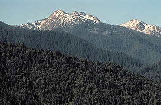
Mount Ashland is the highest peak in the Siskiyou Mountains of southern Oregon. It was named for the city of Ashland, located 8.6 miles (14 km) north of the mountain. The Siskiyou Mountains are a subrange of the Klamath Mountains in northwestern California and southwestern Oregon. The mountain is part of the Rogue River–Siskiyou National Forest, which encompasses most of the Siskiyou Mountains. The Oregon–California border is 5 miles (8 km) south of the mountain.

For the mountain in California formerly named Summit Peak, see Mount Ina Coolbrith.