Kankama

Last updated
Kankama
Sub-prefecture and town
Guinea adm location map.svg
Red pog.svg
Kankama
Location in Guinea
Coordinates: 10°47′N11°25′W / 10.783°N 11.417°W / 10.783; -11.417
CountryFlag of Guinea.svg  Guinea
Region Faranah Region
Prefecture Dabola Prefecture
Population
 (2014)
  Total13,262
Time zone UTC+0 (GMT)

Kankama is a town and sub-prefecture in the Dabola Prefecture in the Faranah Region of Guinea. [1] As of 2014 it had a population of 13,262 people. [2]

Town settlement that is bigger than a village but smaller than a city

A town is a human settlement. Towns are generally larger than villages but smaller than cities, though the criteria to distinguish them vary considerably between different parts of the world.

Sub-prefectures of Guinea

The sub-prefectures are the third-level administrative divisions in Guinea. As of 2009 there were 303 rural sub-prefectures of Guinea and 38 urban sub-prefectures, 5 of which compose the Conakry greater urban area; Kaloum, Dixinn, Matam, Ratoma and Matoto.

Dabola Prefecture Prefecture in Faranah Region, Guinea

Dabola is a prefecture located in the Faranah Region of Guinea. The capital is Dabola. The prefecture covers an area of 6,350 km.² and has an estimated population of 182,951.

Related Research Articles

Villarrabé is a municipality located in the province of Palencia, Castile and León, Spain. According to the 2004 census (INE), the municipality has a population of 251 inhabitants.

Burgohondo Place in Castile and León, Spain

Burgohondo is a municipality located in the province of Ávila, Castile and León, Spain. According to the 2004 census (INE), the municipality has a population of 1,184 inhabitants. It is located in the center of the Valle del Alberche, and area located in the Sierra de Gredos. Its territory has an extension of 55.34 km2,

Villacastín Place in Castile and León, Spain

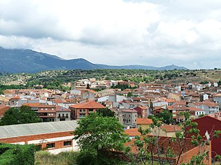
Villacastín is a municipality located in the province of Segovia, Castile and León, Spain. According to the 2004 census (INE), the municipality has a population of 1,572 inhabitants.

Matapozuelos is a municipality located in the province of Valladolid, Castile and León, Spain. According to the 2004 census (INE), the municipality had a population of 1,024 inhabitants.

Karala Sub-prefecture and town in Nzérékoré Region, Guinea

Karala is a town and sub-prefecture in the Beyla Prefecture in the Nzérékoré Region of south-eastern Guinea.

Tougnifili Sub-prefecture and town in Boké Region, Guinea

Tougnifili is a town and sub-prefecture in the Boffa Prefecture in the Boké Region of western Guinea. As of 2014 it had a population of 33,005 people.

Beindou, Faranah Sub-prefecture and town in Faranah Region, Guinea

Beindou is a town and sub-prefecture in the Faranah Prefecture in the Faranah Region of Guinea. As of 2014 it had a population of 16,521 people.

Marela Sub-prefecture and town in Faranah Region, Guinea

Marela is a town and sub-prefecture in the Faranah Prefecture in the Faranah Region of Guinea. As of 2014 it had a population of 32,638 people.

Boula, Guinea Sub-prefecture and town in Kankan Region, Guinea

Boula is a town and sub-prefecture in the Kankan Prefecture in the Kankan Region of eastern Guinea. As of 2014 it had a population of 15,763 people.

Kanfamoriyah Sub-prefecture in Kankan Region, Guinea

Karfamoria is a town and sub-prefecture in the Kankan Prefecture in the Kankan Region of eastern Guinea. As of 2014 it had a population of 24,858 people.

Firawa Sub-prefecture and town in Faranah Region, Guinea

Firawa is a town and sub-prefecture in the Kissidougou Prefecture in the Faranah Region of Guinea. As of 2014 it had a population of 11,407 people.

Manfran Sub-prefecture and town in Faranah Region, Guinea

Manfran is a town and sub-prefecture in the Kissidougou Prefecture in the Faranah Region of Guinea. As of 2014 it had a population of 14,385 people.

Kamaby Sub-prefecture and town in Boké Region, Guinea

Kamaby is a town and sub-prefecture in the Koundara Prefecture in the Boké Region of northern Guinea. As of 2014 it had a population of 16,178 people.

Termesse Sub-prefecture and town in Boké Region, Guinea

Termesse is a town and sub-prefecture in the Koundara Prefecture in the Boké Region of northern Guinea. As of 2014 it had a population of 15,264 people.

Komola-Koura Sub-prefecture and town in Kankan Region, Guinea

Komola-Koura is a town and sub-prefecture in the Kouroussa Prefecture in the Kankan Region of eastern-central Guinea. As of 2014 it had a population of 13,941 people.

Sanguiana Sub-prefecture and town in Kankan Region, Guinea

Sanguiana is a town and sub-prefecture in the Kouroussa Prefecture in the Kankan Region of eastern-central Guinea. As of 2014 it had a population of 23,809 people.

Gongore Sub-prefecture and town in Mamou Region, Guinea

Gongore is a town and sub-prefecture in the Pita Prefecture in the Mamou Region of northern-central Guinea.

Doko, Guinea Sub-prefecture and town in Kankan Region, Guinea

Doko is a town and sub-prefecture in the Siguiri Prefecture in the Kankan Region of northern Guinea.

Kollet, Labé Sub-prefecture and town in Labé Region, Guinea

Kollet is a town and sub-prefecture in the Tougué Prefecture in the Labé Region of northern-central Guinea.

Tountouroun Sub-prefecture and town in Labé Region, Guinea

Tountouroun is a town and sub-prefecture in the Labé Prefecture in the Labé Region of northern-central Guinea.

References

  1. "Subprefectures of Guinea". Statoids. Retrieved February 26, 2009.
  2. "Guinea". Institut National de la Statistique, Guinea, accessed via Geohive. Archived from the original on 24 November 2015. Retrieved 27 August 2014.

Coordinates: 10°47′N11°25′W / 10.783°N 11.417°W / 10.783; -11.417

Geographic coordinate system Coordinate system

A geographic coordinate system is a coordinate system that enables every location on Earth to be specified by a set of numbers, letters or symbols. The coordinates are often chosen such that one of the numbers represents a vertical position and two or three of the numbers represent a horizontal position; alternatively, a geographic position may be expressed in a combined three-dimensional Cartesian vector. A common choice of coordinates is latitude, longitude and elevation. To specify a location on a plane requires a map projection.