
Shajapur District is a district of Madhya Pradesh state of central India. The town of Shajapur is the district headquarters.

Dewas District is a district in the Indian state of Madhya Pradesh. The town of Dewas is the district headquarters.
Khargone district, formerly known as West Nimar district, is a district of Madhya Pradesh state in central India. The district lies in the Nimar region, and is part of the Indore Division. Khargone city is the headquarters of this district which lies south to Indore metropolis and headquarters of Indore District.

Rajgarh district is a district of Madhya Pradesh in central India. The city of Rajgarh is the administrative headquarters of the district. The old name of Rajgarh was Jhanjhanipur, and was ruled by the Bhils. Rajgarh in Madhya Pradesh is one of the aspirational districts selected by Government of India. The district has an area of 6,154 km² and the population is 1,545,814. The district lies on the northern edge of the Malwa plateau, and the Parbati River forms the eastern boundary of the district, while the Kali Sindh River forms the western boundary. The district has seven tehsils, Rajgarh, Khilchipur, Jirapur, Biaora, Narsinghgarh, Sarangpur and Pachore. The district is bounded by Rajasthan state to the north, and by the districts of Guna to the northeast, Bhopal to the east, Sehore to the southeast, and Shajapur to the south and west. It is part of Bhopal Division. There are 1728 villages in Rajgarh.
The Indore District is a district of Madhya Pradesh state in central India. It is believed that the city is named after its Indreshwar Mahadev Temple, Where Indra is the presiding deity. The Gupta inscriptions name Indore as "Indrapura". It is also called the administrative capital. This district forms part of the Indore Division.

Bhopal District is a district of Madhya Pradesh state in central India. The city of Bhopal serves as its administrative headquarters. The district is part of Bhopal Division.

Hatpipalya is a town and a Nagar parishad in the Hatpipliya tehsil within Dewas district of the state of Madhya Pradesh, India. It lies 149 kilometres (93 mi) west of the state capital of Bhopal. Hatpipalya had a census-estimated 2011 population of 17,419, which makes it a Tier-4 city. The city is spread over an area of 2.21 square kilometres (0.85 sq mi).
Satwas is a town and a Nagar Panchayat in Dewas district in the Indian state of Madhya Pradesh. Satwas is around 136.8Km from Dewas.
Bagli is a town and a nagar panchayat in the Malwa region of Dewas district in the state of Madhya Pradesh, India. Bagli is around 66 km (41 mi) from Dewas.

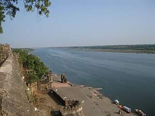
Nemawar is a small town in Dewas District, Madhya Pradesh, India. Handia is located on the left bank of the Narmada river opposite to Handia. However, it belongs to Khategaon block and tehsil of the Dewas district
Dewas is a town in Dewas District. It may also refer to:

Vidisha Assembly constituency Vidhan Sabha seat is one of the 230 Vidhan Sabha constituencies of Madhya Pradesh state in central India. This constituency came into existence in 1957, as one of the Vidhan Sabha constituencies of Madhya Pradesh state. Presently INC's Shashank Bhargava is the MLA from this constituency. Preceding Kalyan Singh Thakur in 2014 when the by-election for this seat held in 2014 after CM of Madhya Pradesh Shivraj Singh Chouhan resigned from this constituency post registering victory at two seats Budhni and Vidisha Assembly constituency.

Basoda Assembly constituency is one of the 230 Vidhan Sabha constituencies of Madhya Pradesh state in central India. This constituency came into existence in 1962, as one of the Vidhan Sabha constituencies of Madhya Pradesh state.
Dongargaon, Agar Malwa is a town and a Gram Panchayat in Agar district in the Indian state of Madhya Pradesh. It is located on the Indore–Kota National Highway on the bank of Kali Sindh River. It is surrounded by the border with the state of Rajasthan from three sides and is a well-known center of transport business between the two states.

Hatpipliya Assembly constituency is one of the 230 Vidhan Sabha constituencies of Madhya Pradesh state in central India. It was created in 1976 and is one of the 5 Vidhan Sabha constituencies located in Dewas District and one of the 8 constituencies within Dewas. This constituency covers Hatpipliya tehsil and parts of Dewas tehsil, both in Dewas district.
Tonk Khurd is a city in Dewas district, in the state of Madhya Pradesh, India. It is the headquarters of Tonk Khurd tehsil and lies 28 km (17 mi) north-east of the district headquarters of Dewas and 172 km (107 mi) west of the state capital, Bhopal.
Agarda is a village and a panchayat in Khategaon tehsil of Dewas district in the Indian state of Madhya Pradesh. As of the 2011 Census of India, the village had a population of 907 spread over 161 households.
Khategaon tehsil is a tehsil in Dewas district, Madhya Pradesh, India. It is also a subdivision of the administrative and revenue division of bhopal district of Madhya Pradesh.
Satwas tehsil is a tehsil in Dewas district, Madhya Pradesh, India. It is also a subdivision of the administrative and revenue division of bhopal district of Madhya Pradesh.
Tonk Khurd tehsil is a tehsil in Dewas district, Madhya Pradesh, India. It is also a subdivision of the administrative and revenue division of bhopal district of Madhya Pradesh.

