
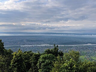
Kathmandu, officially the Kathmandu Metropolitan City, is the seat of federal government and the most populous city in Nepal. As of the 2021 Nepal census, there were 845,767 inhabitants living in 105,649 households and approximately 4 million people in its surrounding agglomeration. It is located in the Kathmandu Valley, a large valley surrounded by hills in the high plateaus in central Nepal, at an altitude of 1,400 metres.
Nepal is a landlocked country where transportation is difficult due to the mountainous terrain. Modern transportation in Nepal has just started in the 20th century.

Mahendra Bir Bikram Shah Dev, was the ninth King of Nepal from 13 March 1955 until his death in 1972, which was due to a heart attack, as told in an interview by his personal physician Dr. Mrigendra Raj Pandey. Following the 1960 coup d'état, he established the party-less Panchayat system, which governed the country for 28 years until the introduction of multi-party democracy in 1990. During his reign, Nepal experienced a period of industrial, political and economic change which opened it to the rest of the world for the first time, after the 104-year-long reign of the Rana rulers, who kept the country under an isolationist policy, came to an end in 1951.
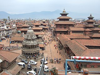
Lalitpur Metropolitan City, also known as Patan, Yala, and Manigal, is a metropolitan city and fourth most populous city of Nepal with 299,843 inhabitants living in 49,044 households per the 2021 census. It is located in the south-central part of Kathmandu Valley, a large valley in the high plateaus in central Nepal, at an altitude of 1,400 metres.

Dhangadhi is a sub-metropolitan city and the district headquarters of Kailali District in Sudurpashchim Province of Nepal. It shares a border with India in the south, Godawari and Gauriganga Municipality in the North, Kailari Rural Municipality in the east and Kanchanpur District in the west. Dhangadhi is a sub-metropolis divided into 19 wards. It has an area of 271.74 Sq. KM. It is one of the major cities of Far - West Province of Nepal along with Mahendranagar. The city is connected with the Mahakali Highway, about 750 kilometers west of Kathmandu.

Siddhidas Mahaju was a Nepalese poet and one of the Four Pillars of Nepal Bhasa. He was at the forefront in the endeavour to revive literature in Nepal Bhasa that had become stagnant as a result of official suppression. He has been honored with the title Great Poet.

Birgunj is a metropolitan city in Parsa District in Madhes Pradesh in southern Nepal. It lies 135 km (84 mi) south of the capital Kathmandu, attached in the north to Raxaul on the border of the Indian state of Bihar. As an entry point to Nepal from Patna, Birganj is known as the "Gateway of Nepal". It is also called the "Commercial Capital of Nepal". The town has significant economic importance for Nepal as most of the trade with India is via Birganj and the Indian town of Raxaul. The Tribhuvan Highway links Birgunj to Nepal's capital, Kathmandu.

Butwal, officially Butwal Sub-Metropolitan City ,previously known as Khasyauli, is a sub-metropolitan city and economic hub in Lumbini Province in West Nepal. Butwal has a city population of 195,054 as per the 2021 AD Nepal census.
Bharatpur is a city in south central Nepal. It is the third most populous city of Nepal after Kathmandu and Pokhara with 369,377 inhabitants in 2021. It is also the second largest metropolitan city in Nepal by area. It is the district headquarter of the Chitwan District.

Bhimphedi, is a village located in the Bhimphedi Rural Municipality of Makwanpur District of Bagmati Province of Nepal. This village is known for its bazaar (marketplace). Bismuth ore is mined here.
Hetauda is a sub-metropolitan city in Makwanpur district of Bagmati Province in central Nepal. It is the administrative headquarters of the Makwanpur district and the capital of Bagmati Province as declared by a majority of the Provincial Assembly Members on 12 January 2020. Hetauda is one of the largest cities in Nepal. At the 2015 Nepal census, it had a population of 153,875 people. The city's population grew to 195,951 in 2021.

Ghorahi is the largest sub-metropolitan city by area and population of Lumbini Province. The city lies in Lumbini Province in the Mid-Western part of Nepal. It is the largest city of Dang Deukhuri District of southwest Nepal. Located in the Inner Terai region, it lies 413 kilometres (257 mi) south-west of Nepal's capital Kathmandu and is one of the Counter Magnets being developed as an alternative centre of growth to help ease the migration and population explosion in the Kathmandu metropolitan area. It is the largest city of the Rapti Zone and is surrounded by the Sivalik Hills to the south and Mahabharata Range to the north.

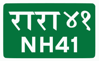
Mahendra Highway or NH01, also called East-West Highway, runs across the Terai geographical region of Nepal, from Mechinagar in the east to Bhim Datta in the west, cutting across the entire width of the country. It is the longest highway in Nepal and was constructed in cooperation with various countries. The highway is named after King Mahendra Shah.
Jitpursimara is a sub-metropolitan city in Bara District in Province No. 2 of southern Nepal that was formed on 10 March 2017 after merging Gadhimai Municipality, Inarwasira, Amlekhganj, as well as parts of Manharwa, Haraiya and Rampur Tokani to form a new sub-metropolitan city. At the time of the 2011 Nepal census, the former settlements that would make up the sub-metropolitan city had a joint population of 117,094 people living in 21,670 individual households.
The Tribhuvan Highway (Nepali: त्रिभुवन राजपथ) connects the outskirts of Kathmandu, the capital of Nepal, with Birganj/Raxaul on the Nepal-India border. NH 28 and NH 28A links Raxaul with Lucknow/Barauni and other locations in India.

Kul Ratna Tuladhar, CBE was the first chief engineer of Nepal's Public Works Department where he served since its establishment in 1951 till 1957. The highlight of his term was the construction of Tribhuvan Highway which opened in 1956. This is Nepal's first highway and links the capital Kathmandu with the Indian border to the south.

Kodari is a small village located at the border with Tibet-China. The village is located at the end–point of the Arniko Highway, which connects Kodari with the capital city of Kathmandu. Kathmandu is 144 kilometres (89 mi) away from Kodari. Kodari is a major border crossing from Nepal into the Tibet Autonomous Region.

Bagmati Province is one of the seven provinces of Nepal established by the constitution of Nepal. Bagmati is Nepal's second-most populous province and fifth largest province by area. It is bordered by Tibet Autonomous Region of China to the north, Gandaki Province to the west, Koshi Province to the east, Madhesh Province and the Indian state of Bihar to the south. With Hetauda as its provincial headquarters, the province is also the home to the country's capital Kathmandu, is mostly hilly and mountainous, and hosts mountain peaks including Gaurishankar, Langtang, Jugal, and Ganesh.

Lumbini Province is a province in western Nepal. The country's third largest province in terms of area as well as population, Lumbini is home to the World Heritage Site of Lumbini, where according to the Buddhist tradition, the founder of Buddhism, Gautama Buddha was born.

The Churia Tunnel is a 500 m (1,600 ft)-long highway tunnel carved through the churia hill between Makwanpur and Bara of Nepal. It was constructed connecting the country's first motorable road between Amlekhganj in the terai and Bhimphedi settlement of Makwanpur, the point of entry into Kathmandu which served as a dry port, in the trade route between Kathmandu and Raxaul.

