This article needs additional citations for verification .(February 2022) |

The Karaj River is a river on the central plateau of Iran. [1] It is the second largest river after Zayandarud in the central plateau region. [1]
This article needs additional citations for verification .(February 2022) |
The Karaj River is a river on the central plateau of Iran. [1] It is the second largest river after Zayandarud in the central plateau region. [1]
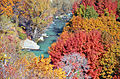
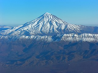
The Karaj River runs roughly 152 miles (245 km) in length. [1] Its headwaters are in the Central Alborz mountain range, north of Tehran in Alborz Province. It flows south past the city of Karaj, and then flows eastward with its tributary Jajrood River joining in Tehran Province, to flow into the endorheic Namak Lake basin in the Qom Province.
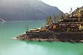
The Amir Kabir Dam is constructed across the river in the foothills of the Alborz mountain range.


Geographically, the country of Iran is located in West Asia and borders the Caspian Sea, Persian Gulf, and Gulf of Oman. Topographically, it is predominantly located on the Persian Plateau. Its mountains have impacted both the political and the economic history of the country for several centuries. The mountains enclose several broad basins, on which major agricultural and urban settlements are located. Until the 20th century, when major highways and railroads were constructed through the mountains to connect the population centers, these basins tended to be relatively isolated from one another.

Tehran province is one of the 31 provinces of Iran. It covers an area of 18,814 square kilometres (7,264 sq mi) and is located to the north of the central plateau of Iran.

Shahre Ray, Shahr-e Ray, Shahre Rey, or Shahr-e Rey or simply Ray or Rey (ری), is the capital of Rey County in Tehran Province, Iran. Formerly a distinct city, it has now been absorbed into the metropolitan area of Greater Tehran as the 20th district of municipal Tehran, the capital city of the country.

The Iranian plateau or Persian plateau is a geological feature spanning parts of West Asia, Central Asia, and South Asia. It makes up part of the Eurasian Plate, and is wedged between the Arabian Plate and the Indian Plate. The plateau is situated between the Zagros Mountains to the west, the Caspian Sea and the Köpet Dag to the north, the Armenian Highlands and the Caucasus Mountains to the northwest, the Strait of Hormuz and the Persian Gulf to the south, and the Indian subcontinent to the east.

Karaj is the fourth-largest city in Iran and is near the country's capital, Tehran. It is in the Central District of Karaj County, Alborz province, Iran, and serves as the county seat.

Greater Tehran Metropolitan Area is the urban agglomeration around Tehran that covers the central part of the Tehran Province and eastern part of the Alborz Province, that covers the contiguous cities of Tehran, Ray, Shemirānāt, and other areas.

The Haraz River is a notable river flowing through the Mazandaran Province of northern Iran. It flows northwards, from the Alborz mountain range into the Caspian Sea. Haraz river after flowing along the Haraz Road and Valley for about 100 km it meanders in the midst of Amol, from where it reaches the Caspian Sea. Haraz River begins from Mount Damavand and flows northward and pours into Caspian Sea in the area between the two northern cities of Mahmoudabad and Fereydunkenar. The Haraz River is currently contaminated due to discharges of effluent from various industrial plants.

Karaj County is in Alborz province, Iran. The capital of the county is the city of Karaj.
Amol County is in Mazandaran province, Iran. Its capital is the city of Amol.

The Sefid-Rud is a river approximately 670 kilometres (416 mi) long, rising in the Alborz mountain range of northwestern Iran and flowing generally northeast to enter the Caspian Sea at Rasht.
Charan is a village in Adaran Rural District, Asara District, Karaj County, Alborz Province, Iran. At the 2006 census, its population was 528, in 143 families.

The Jajrud (Jājrūd), also spelled as Jajrood, Djadjéroud or Djaderoud, is a river in northern Iran that passes through the provinces of Mazandaran and Tehran. It flows south through the central Alborz mountain range. It is a tributary of the Karaj River, which empties into the endorheic Namak Lake basin.

Road 77, also known as the Haraz Road, is one of the most important roads from Tehran to the northern mountains of Iran, and the Iranian coast on the southern Caspian Sea. Amol is the first northern city of this road. Along the road landscapes, Plain, Mountain, Historical tourism. Waterfall and village.
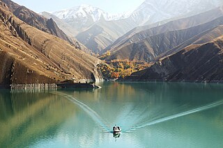
Amir Kabir dam, also known as Karaj dam, is a dam on the Karaj River in the Central Alborz mountain range of northern Iran.

Alborz province is one of the 31 provinces of Iran. Karaj is the seat of the province, which is situated 10 km west of Tehran, at the foothills of the Alborz mountains. It is Iran's smallest province in area.
Asara is a city in Asara District of Karaj County, Alborz province, Iran. It is located in the Alborz (Elburz) mountain range.

Mahestan, with the former name of Hashtgerd New City, is in the Central District of Savojbolagh County, Alborz province. Located in the vicinity of Hashtgerd, it was built in recent years.

Central Iran consists of the southern slopes of the Alborz Mountains in the north, the Zagros Mountains in south, the Central Iranian Range, and the desert of Dasht-e Kavir.

District 5 is one of 22 central districts of Tehran County in Tehran Province, Iran. This district is limited to Kan River and lands of District 22 in the west and to Mohammad Ali Jenah and Ashrafi Esfahani highways in the east. At the 2010 census, its population was 793,750, in 255,333 families.
The 1957 Sangchal earthquake struck northern Iran's Mazandaran province on 2 July 1957. It had a moment magnitude of 6.6 or 7.1 (Mw ), focal depth of 15 km (9.3 mi), and maximum Modified Mercalli intensity of IX (Violent). It devastated many communities in the Alborz Mountains and caused an estimated 1,500 fatalities. Damage was estimated at US$ 25 milion.
34°46′50″N51°49′51″E / 34.78056°N 51.83083°E
| Lake Urmia basin | |
|---|---|
| Persian Gulf basin | |
| Oman sea basin | |
| Caspian basin | |
| Gavkhouni basin | |
| Namak Lake basin | |
| Hamun-e Jaz Murian basin | |
| Other | |