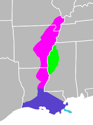
The Mississippi River Alluvial Plain is an alluvial plain created by the Mississippi River on which lie parts of seven U.S. states, from southern Louisiana to southern Illinois.

The River Looe is a river in south-east Cornwall, which flows into the English Channel at Looe. It has two main branches, the East Looe River and the West Looe River. The eastern branch has its source near St Cleer only 0.31 miles (0.5 km) away from the Golitha Falls on the River Fowey, and flows south, passing close to the western outskirts of Liskeard. The western branch has its source near Dobwalls.

The Nissitissit River is a 10.5-mile-long (16.9 km) river in southern New Hampshire and northern Massachusetts in the United States. It is a tributary of the Nashua River, itself a tributary of the Merrimack River, which flows to the Gulf of Maine. This river is part of the Nashua River Watershed.
Beaver Brook is a 30.7-mile-long (49.4 km) river located in New Hampshire and Massachusetts in the United States. It is a tributary of the Merrimack River, part of the Gulf of Maine watershed.

The Spicket River is a 17.7-mile-long (28.5 km) river located in New Hampshire and Massachusetts in the United States. It is a left tributary of the Merrimack River, part of the Gulf of Maine watershed. It is sometimes spelled "Spickett".
The Little River is a 12.9-mile-long (20.8 km) river in New Hampshire and Massachusetts in the United States. It is a tributary of the Merrimack River, part of the Gulf of Maine watershed.

The Haraz River is a notable river flowing through the Mazandaran Province of northern Iran. It flows northwards, from the Alborz mountain range into the Caspian Sea. After flowing along the Haraz Road and Valley for about 100 km, the Haraz river meanders in the midst of Amol, from where it reaches the Caspian Sea. The Haraz begins in Mount Damavand and flows northward and pours into Caspian Sea in the area between the two northern cities of Mahmoudabad and Fereydunkenar. The Haraz is currently contaminated due to discharge of effluent from various industrial plants.
The South Branch of the Souhegan River is a 5.8-mile-long (9.3 km) river located in northern Massachusetts and southern New Hampshire in the United States. It is a tributary of the Souhegan River, which flows to the Merrimack River and ultimately to the Gulf of Maine.

The Blackwater River is a 3.1-mile-long (5.0 km) tidal inlet in northeastern Massachusetts and southeastern New Hampshire in the United States.

Edward River, or Kyalite River, an anabranch of the Murray River and part of the Murray–Darling basin, is located in the western Riverina region of south-western New South Wales, Australia.

The River Tiddy is a small river in south-east Cornwall, the main tributary of the River Lynher. The Tiddy rises near Pensilva and flows south east past the village of Tideford until it joins the Lynher just after passing St Germans. The name of Tideford derives from its location on the river, literally meaning "Ford on the River Tiddy".

The Two Rivers National Wildlife Refuge is located on the Illinois River and the Mississippi River in parts of Calhoun, Jersey, and Greene counties in Illinois, and St. Charles County, Missouri. It is managed by the U.S. Fish and Wildlife Service as part of the Mark Twain National Wildlife Refuge Complex.

The River Allen in north Cornwall is one of two rivers in Cornwall which share this name. In this case the name is the result of a mistake made in 1888 by Ordnance Survey, replacing the name Layne with Allen which is the old name for the lower reaches of the Camel. The other River Allen runs through Truro.

Pages River, a perennial river of the Hunter River catchment, is located in the Hunter region of New South Wales, Australia.
Wangat River, a perennial river of the Hunter River catchment, is located in the Hunter region of New South Wales, Australia.

Wakool River, an anabranch of the Edward River that is part of the Murray River catchment within the Murray–Darling basin, is located in the western Riverina region of south western New South Wales, Australia.

The River Kensey is a river in east Cornwall, England, UK which is a tributary of the River Tamar.
The River Seaton is a river in east Cornwall, England, UK which flows southwards for 11 miles (17 km) into the English Channel.
Kia River Awyu, or Jair (Djair), is a Papuan language of Papua, Indonesia, spoken along the Kia River. It is closely related to Edera River Awyu. Upper Kia River Awyu and Lower Kia River Awyu may be distinct languages, depending on one's criteria.
This page is based on this
Wikipedia article Text is available under the
CC BY-SA 4.0 license; additional terms may apply.
Images, videos and audio are available under their respective licenses.
