
Geographically, the country of Iran is located in West Asia and the bodies of water the nation borders are the Caspian Sea, Persian Gulf, and Gulf of Oman. Topographically, it is predominantly located on the Iranian/Persian plateau, Its mountains have impacted both the political and the economic history of the country for several centuries. The mountains enclose several broad basins, on which major agricultural and urban settlements are located. Until the 20th century, when major highways and railroads were constructed through the mountains to connect the population centers, these basins tended to be relatively isolated from one another.

Kurdistan, or Greater Kurdistan, is a roughly defined geo-cultural region in West Asia wherein the Kurds form a prominent majority population and the Kurdish culture, languages, and national identity have historically been based. Geographically, Kurdistan roughly encompasses the northwestern Zagros and the eastern Taurus mountain ranges.

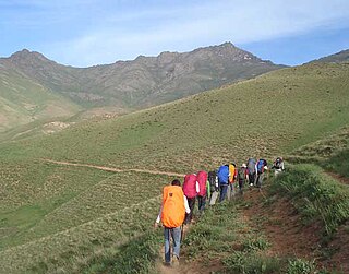
The Zagros Mountains are a long mountain range in Iran, northern Iraq, and southeastern Turkey. The mountain range has a total length of 1,600 km. The Zagros range begins in northwestern Iran and roughly follows Iran's western border while covering much of southeastern Turkey and northeastern Iraq. From this border region, the range continues southeast to the waters of the Persian Gulf. It spans the southern parts of the Armenian highlands, and the whole length of the western and southwestern Iranian plateau, ending at the Strait of Hormuz. The highest point is Mount Dena, at 4,409 metres (14,465 ft).

Urmia is the largest city in West Azerbaijan Province of Iran. In the Central District of Urmia County, it is capital of the province, the county, and the district.

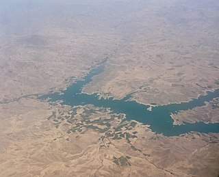
Lake Urmia is an endorheic salt lake in Iran. The lake is located between the provinces of East Azerbaijan and West Azerbaijan in Iran, and west of the southern portion of the Caspian Sea. At its greatest extent, it was the largest lake in the Middle East. It is the sixth-largest saltwater lake on Earth, with a surface area of approximately 6,000 km2 (2,300 sq mi), a length of 140 km (87 mi), a width of 70 km (43 mi), and a maximum depth of 20 m (66 ft).
The Little Zab or Lower Zab is a river that originates in Iran and joins the Tigris just south of Al Zab in the Kurdistan region of Iraq. The Little Zab is approximately 400 kilometres (250 mi) long and drains an area of about 22,000 square kilometres (8,500 sq mi). The river is fed by rainfall and snowmelt, resulting in a peak discharge in the spring and low water in the summer and early fall. Two dams built on the Little Zab regulate the river flow, providing water for irrigation and generating hydroelectricity. The Zagros Mountains have been populated since at least the Lower Palaeolithic, but the earliest archaeological site in the Little Zab basin, Barda Balka, dates to the Middle Palaeolithic. Human occupation of the Little Zab basin has been attested for every period since then.
Muṣaṣir, in Urartian Ardini was an ancient city of Urartu, attested in Assyrian sources of the 9th and 8th centuries BC.

Arthur T. Gregorian,, was a Greater Boston oriental rug dealer and author of books on oriental rugs. He is considered by some to be the world's leading collector of rare, inscribed Armenian rugs.
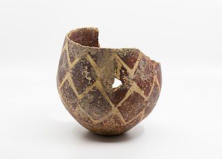
Hajji Firuz Tepe is an archaeological site located in West Azarbaijan Province in north-western Iran and lies in the north-western part of the Zagros Mountains. The site was excavated between 1958 and 1968 by archaeologists from the University of Pennsylvania Museum of Archaeology and Anthropology. The excavations revealed a Neolithic village that was occupied in the second half of the sixth millennium BC where some of the oldest archaeological evidence of grape-based wine was discovered in the form of organic residue in a pottery jar.

The Zarrineh Rud is a river in Kurdistan Province and West Azarbaijan Province, Iran.

The Gadar River rises in the Iranian Zagros Mountains close to where the borders of Iran, Turkey and Iraq meet. From its source, the river flows towards the southeast and then changes course due east through the Ushnu-Solduz valley. After leaving the valley, the river turns north and flows into the marshes bordering the endorheic saltwater Lake Urmia. The length of the river is approximately 100 kilometres (62 mi), its drainage basin is variously estimated as 1,900 square kilometres (730 sq mi) and 2,123 square kilometres (820 sq mi) and its discharge is 0.34 cubic metres (12 cu ft) per second. The Ushnu-Solduz valley has been occupied for many millennia, as testified by the excavations at sites like Hasanlu Tepe and Hajji Firuz Tepe.

Iranrud which means Iran River in Persian, was a plan to build a canal from the Caspian Sea to the Persian Gulf. The former Soviet Union was eager to realize this project because its only warm water ports led to the Strait of Istanbul and the Dardanelles, which were under the control of Turkey, a NATO country.

The Eastern Anatolian montane steppe is a temperate grasslands, savannas, and shrublands ecoregion. It is located in the Armenian Highlands, covering parts of eastern Turkey, Armenia, Azerbaijan, southern Georgia, and northwestern Iran.

The Zola River, also known as the Zola Chai is a river in Iran, flowing into Lake Urmia. It runs north of Urmia and west of Salmas city in West Azerbaijan province. Rising in the mountains along the border with Turkey, the Zola flows southwest along the Salmas Plain. The river has a catchment area of 846 km².

The Laylan is an endorheic river in western Iran.

The Simineh River, also known as the Tatavi Chay, is a river in northern Iran, arising in the Zagros Mountains of Kurdistan Province north of Saqqez, that flows into the south end of Lake Urmia. It is just over 200 kilometres (124 mi) long and has a catchment basin (watershed) of 2,090 square kilometres (810 sq mi). Its waters are used primarily for agriculture and the return flow significantly degrades its water quality.

Western Iran consists of Armenian Highlands, northern Zagros and the rich agricultural area of the Khuzestan Plain in the south.
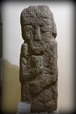
Dalma culture was a prehistoric archaeological culture of north-western Iran dating to early fifth millennium B.C. Later, it spread into the central Zagros region and elsewhere in adjacent areas. Its widespread ceramic remains were excavated in central and northern valleys of the Zagros Mountains in north-western Iran. Dalma assemblages were initially discovered by the excavations carried out at Dalma Tepe and Hasanlu Tepe in south-western parts of Lake Urmia, in the valley of Solduz.
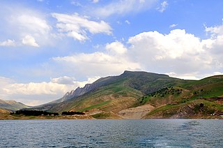
Shahid Kazemi Dam is a clay core dam on the Zarrineh River in the Zagros Mountains range, located near Bukan in West Azarbaijan Province, Iran.
Mount ChlChama is a part of the Zagros mountains, which are located in Iran, between the cities of Saqqez, Divandarreh and Marivan in Kurdistan province. The highest peak of Chlchama, also known as Chlchama, is 3,173 metres above sea level, near the villages of Isakawa and Kanemat, 56 kilometres southwest of Saqqez.
