Karakoram–West Tibetan Plateau alpine steppe

Last updated
Karakoram-West Tibetan Plateau alpine steppe
Karakoram-West Tibetan Plateau alpine steppe.jpg
Karakoram-West Tibetan Plateau alpine steppe near Ladakh, India
Ecoregion PA1006.png
Ecoregion territory (in purple)
Ecology
Biome Montane grasslands and shrublands
Borders
Bird species172 [1]
Mammal species45 [1]
Geography
Area143,300 km2 (55,300 sq mi)
Countries India, China, Afghanistan and Pakistan
Conservation
Habitat loss1.4065% [1]
Protected18.28% [1]

The Karakoram-West Tibetan Plateau alpine steppe is a montane grasslands and shrublands ecoregion found in parts of Pakistan, China, Afghanistan, and India.

Contents

Setting

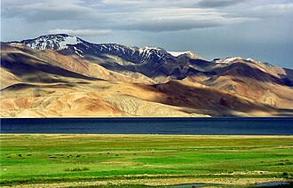
The Karakoram-West Tibetan Plateau alpine steppe is an area of high-elevation grasslands covering 143,300 square kilometres (55,300 sq mi). It is centered on the Karakoram Range, west of the Himalaya Range. It also includes nearby ranges, such as the Ladakh Range.

Climate

The mean annual precipitation in the ecoregion varies from 200 to 900 millimetres (7.9 to 35.4 in), 90 percent in the form of snow.

Flora

Deosai National Park in Pakistan. Deosai Plateau 2.jpg
Deosai National Park in Pakistan.

Most of this ecoregion consists of grasslands and herbaceous plants. Protected slopes and ravines contains Salix denticulata, Mertensia tibetica, Potentilla desertorum, Juniperus polycarpus, Polygonum viviparum, Berberis pachyacantha, Rosa webbiana , and Spiraea lycoides . Where vegetation ceases to grow, around 4,500 metres (14,800 ft), are found Delphinium cashmerianum, Glechoma tibetica, Silene longicarpophora, Potentilla fruticosa , and Nepeta spp.

Shrublands and woodlands are found in valley bottoms. These include Hippophae rhamnoides, Myricaria elegans, Salix viminalis, Capparis spinosa, Tribulus terrestris, Pegamum harmala, Sophora alopecuroides , and Lycium ruthenicum . A few remnant steppe forests of Juniperus seravschanica and Juniperus indica are still found here.

Fauna

Sheep in this ecoregion include the Marco Polo sheep, Tibetan argali, and urial. Goats include the markhor and ibex.

The sheep and goats, as well as smaller mammals, make this ecoregion excellent habitat for the snow leopard.

Both the brown bear and Himalayan black bear are found here.

Bird species richness is low. Common birds include Guldenstadt's redstart, Himalayan monal, rosefinches, raptors, and vultures.

Conservation

Much of the montane habitat in this ecoregion lies in protected areas. These include

See also

Related Research Articles

The Global 200 is the list of ecoregions identified by WWF, the global conservation organization, as priorities for conservation. According to WWF, an ecoregion is defined as a "relatively large unit of land or water containing a characteristic set of natural communities that share a large majority of their species dynamics, and environmental conditions". So, for example, based on their levels of endemism, Madagascar gets multiple listings, ancient Lake Baikal gets one, and the North American Great Lakes get none.

Montane grasslands and shrublands Biome defined by the World Wildlife Fund

Montane grasslands and shrublands is a biome defined by the World Wildlife Fund. The biome includes high altitude grasslands and shrublands around the world. The term "montane" in the name of the biome refers to "high altitude", rather than the ecological term which denotes the region below treeline.

Hemis National Park National Park in Ladakh, India

Hemis National Park is a high altitude national park in Ladakh, India. Globally famous for its snow leopards, it is believed to have the highest density of them in any protected area in the world. It is the only national park in India that is north of the Himalayas, the largest notified protected area in India and is the second largest contiguous protected area, after the Nanda Devi Biosphere Reserve and surrounding protected areas. The park is home to a number of species of endangered mammals, including the snow leopard. Hemis National Park is India's protected area inside the Palearctic realm, outside the Changthang Wildlife Sanctuary northeast of Hemis, and the proposed Tso Lhamo Cold Desert Conservation Area in North Sikkim.

Intermountain West Geographic region of the Western United States

The Intermountain West, or Intermountain Region, is a geographic and geological region of the Western United States. It is located between the front ranges of the Rocky Mountains on the east and the Cascade Range and Sierra Nevada on the west.

Central Karakoram National Park

Central Karakoram National Park is a national park located in Skardu district of Gilgit-Baltistan in Pakistan. It encompasses some of the world’s highest peaks and largest glaciers. Internationally renowned for mountaineering, rock climbing and trekking opportunities, it covers an area of about 10,000 sq. km and contains the greatest concentration of high mountains on earth. It has four peaks over 8,000 m including K2 (8611 m), Gasherbrum-I (8068 m), Gasherbrum-II (8035 m) and Broad Peak (8051 m), and sixty peaks higher than 7,000 m. The park was placed on the World Heritage Site Tentative List in 2016.

Mountains of Central Asia

The Mountains of Central Asia are a biodiversity hot spot designated by Conservation International which covers several montane and alpine ecoregions of Central Asia, including those of the Pamir and Tian Shan ranges, and extending across portions of Afghanistan, China, Kazakhstan, Kyrgyzstan, Tajikistan, Uzbekistan and the Karakoram range in China, Pakistan and India.

Western Himalayan alpine shrub and meadows

The Western Himalayan alpine shrub and meadows is a montane grasslands and shrublands ecoregion of Nepal, India, and Tibet, which lies between the tree line and snow line in the western portion of the Himalaya Range.

Eastern Himalayan alpine shrub and meadows Ecoregion in the Eastern Himalayas

The Eastern Himalayan alpine shrub and meadows is a montane grasslands and shrublands ecoregion of Bhutan, China, India, Myanmar, and Nepal, which lies between the tree line and snow line in the eastern portion of the Himalaya Range.

Alpine steppe

The Alpine-steppe is a high altitude natural alpine grassland, which is a part of the Montane grasslands and shrublands biome.

Zacatonal Montane grasslands and shrublands ecoregion of central Mexico

The Zacatonal is a montane grassland and shrubland ecoregion of central Mexico.

Central Range sub-alpine grasslands Ecoregion in New Guinea

The Central Range sub-alpine grasslands is a montane grasslands and shrublands ecoregion on the island of New Guinea. The ecoregion covers the highest-elevation portions of the New Guinea Highlands, which extend along the spine of the island. The high elevations support rare tropical sub-alpine and alpine habitats, including many endemic plants and animals.

Northeastern Himalayan subalpine conifer forests Ecoregion in Northeast Himalayas

The Northeastern Himalayan subalpine conifer forests are a temperate coniferous forests ecoregion of the middle to upper elevations of the eastern Himalayas and southeast Tibetan Plateau. The ecoregion occurs in southeastern Tibet Autonomous Region, China, in northern and eastern Arunachal Pradesh, India, and extreme eastern Bhutan.

Northwestern Himalayan alpine shrub and meadows Ecoregion in the Northwestern Himalayas

The Northwestern Himalayan alpine shrub and meadows is a montane grasslands and shrublands ecoregion of the elevations of the northwestern Himalaya of China, India, and Pakistan.

Montane ecosystems Ecosystems found in mountains

Montane ecosystems are found on the slopes of mountains. The alpine climate in these regions strongly affects the ecosystem because temperatures fall as elevation increases, causing the ecosystem to stratify. This stratification is a crucial factor in shaping plant community, biodiversity, metabolic processes and ecosystem dynamics for montane ecosystems. Dense montane forests are common at moderate elevations, due to moderate temperatures and high rainfall. At higher elevations, the climate is harsher, with lower temperatures and higher winds, preventing the growth of trees and causing the plant community to transition to montane grasslands, shrublands or alpine tundra. Due to the unique climate conditions of montane ecosystems, they contain increased numbers of endemic species. Montane ecosystems also exhibit variation in ecosystem services, which include carbon storage and water supply.

Biogeographic classification of India Wikipedia article on biogeography of India

Biogeographic classification of India is the division of India according to biogeographic characteristics. Biogeography is the study of the distribution of species (biology), organisms, and ecosystems in geographic space and through geological time. India has a rich heritage of natural diversity. India ranks fourth in Asia and tenth in the world amongst the top 17 mega-diverse countries in the world. India harbours nearly 11% of the world's floral diversity comprising over 17500 documented flowering plants, 6200 endemic species, 7500 medicinal plants and 246 globally threatened species in only 2.4% of world's land area. India is also home to four biodiversity hotspots—Andaman & Nicobar Islands, Eastern Himalaya, Indo-Burma region, and the Western Ghats. Hence the importance of biogeographical study of India's natural heritage.

Eastern Anatolian montane steppe

The Eastern Anatolian montane steppe is a temperate grasslands, savannas, and shrublands ecoregion. It is located in the Armenian Highlands and the high plateau of Eastern Anatolia, covering parts of eastern Turkey, Armenia, Azerbaijan, southern Georgia, and northwestern Iran.

Southeast Tibet shrub and meadows Ecoregion in the Tibetan Plateau

The Southeast Tibet shrub and meadows are a montane grassland ecoregion that cover the southeast and eastern parts of the Tibetan Plateau in China. The meadows in this region of Tibet are in the path of the monsoon rains and are wetter than the other upland areas of the Tibetan Plateau. The "high cold" alpine terrain is one of high species diversity, due to the relatively high levels of precipitation for the region. Precipitation is lower in the northwest, and hence the vegetation thins from shrub to meadow or even desert.

Pamir alpine desert and tundra Ecoregion in the Pamir Mountains

The Pamir alpine desert and tundra ecoregion covers the high plateau of the Pamir Mountains, at the central meeting of the great mountain ranges of Central Asia: Himalaya, Karakoram, Hindu Kush, Kunlun, and Tian Shan. It is a region of relatively high biodiversity due to its central location and high elevation differentials, but it also acts as a barrier between the climate and habitats of north and south Asia.

Tibetan Plateau alpine shrublands and meadows type of regional vegetation

The Tibetan Plateau alpine shrublands and meadows ecoregion covers the middle transition zone between the northern and southern regions of the Tibetan Plateau. The region supports both cold alpine steppe and meadows across a broad expanse of the plateau. Wild deer, antelope, and sheep roam the grasslands, but the habitat is increasingly being used to graze domestic livestock.

References

  1. 1 2 3 4 Hoekstra, J. M.; Molnar, J. L.; Jennings, M.; Revenga, C.; Spalding, M. D.; Boucher, T. M.; Robertson, J. C.; Heibel, T. J.; Ellison, K. (2010). Molnar, J. L. (ed.). The Atlas of Global Conservation: Changes, Challenges, and Opportunities to Make a Difference . University of California Press. ISBN   978-0-520-26256-0.