
Multan is the fifth-most populous city in the Pakistani province of Punjab. Located in south-central Punjab, along the River Chenab, it is the oldest continuously inhabited city in South Asia; and third oldest in Asia. It has historically been the primary cultural center of the Punjab region; and till this day is one of the most culturally, religiously, and economically significant cities in the region. Being a metropolitan hub, it is the sixth largest in the country, serving as the administrative headquarters of the eponymous district and division.

Ghazipur, is a city in the state of Uttar Pradesh, India. Ghazipur city is the administrative headquarters of the Ghazipur district, one of the four districts that form the Varanasi division of Uttar Pradesh. It is located on the Ganges (Ganga) River near the border with Bihar state, about 40 miles (65 km) northeast of Varanasi (Benares).The city of Ghazipur also constitutes one of the seven distinct tehsils, or subdivisions, of the Ghazipur district.
Rajmahal is a subdivisional town and a notified area in Rajmahal subdivision of the Sahebganj district in the Indian state of Jharkhand. It is situated at the banks of Ganges and was former capital of Bengal Subah under Mughal governor, Man Singh I.
Chārsadda is a town and headquarters of Charsadda District, in the Khyber Pakhtunkhwa province of Pakistan. It is the eighty fifth-largest city of Pakistan, according to 2017 census. Located in the Valley of Peshawar, Charsadda lies about 29 kilometres (18 mi) from the provincial capital of Peshawar at an altitude of 276 metres (906 ft). The total area of Charsadda District measures about 996 square Km. The district is geographically organized into two primary parts: Hashtnagar and Do Aaba.

Midnapore, or sometimes Medinipur, is a former district in the Indian state of West Bengal, headquartered in Midnapore. On 1 January 2002, the district was bifurcated into two separate districts namely Purba Medinipur and Paschim Medinipur. It was the largest district of West Bengal by area and population at the time of bifurcation.
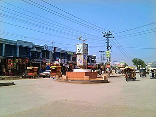
Jagraon is a city and a municipal council, a rural police district and a sub-division of the Ludhiana district in the Indian state of Punjab. Jagraon is more than three centuries old. Jagraon is at almost the geographical center of the state, 16 kilometres (9.9 mi) from the Satluj River. It is 37 km (23 mi) from its district headquarters Ludhiana, 29 km (18 mi) from Moga, 31 km (19 mi) from Nakodar and 54 miles from Barnala.

Jalandhar district is a district in Doaba region of the state of Punjab, India. The district headquarters is the city of Jalandhar.
Mohiuddin Nagar is a block and a notified area in Samastipur district in the Indian state of Bihar, India. It derives its name from Sufi saint Shah Afaq Mohiuddin. He was descendant of Shah Qasim Suleiman of Chunar. Earlier this area was known as Sheher Dharhara. There is a fort named Amina Bibi ka Quila commonly known as Fansighar. She was the wife of Shah Afaq and daughter of rebel Afghan general Shamsher Khan who was killed in battle of Ranisarai with Nawab Alivardi Khan.
Shrirampur is a city and a municipal council located in the Ahmednagar district of the Indian state of Maharashtra.
Bahadurganj is a Municipality located in Zahurabad pargama of the Kasimabad Tehsil in Ghazipur district of Uttar Pradesh, India. Bahadurganj is located one the banks of Tamsa and Bhainsahi rivers.The town also served as the capital of Qasimabad estate.

Islamnagar is a panchayat village in the Bhopal district of Madhya Pradesh, India. It is located in the Huzur tehsil and the Phanda block.
Dildarnagar Kamsar is a pargana (region) and a mashra comprising 34 settlements located around the Karamnasa River in the Ghazipur district of Uttar Pradesh and the Kaimur district of Bihar, India. Of these, 18 mouzas are the primary settlements. It is a prominent settlement of Khanzadas, also known as Kamsari Pathans, as well as Afghan Pathans, primarily of the Niazi and Yusufzai clans. The original name of the region was Kamsar, but due to close and historical ties with the family of Bara Pathans, the region is often referred to as Kamsar-O-Bar. It was established in 1542 by Raja Narhar Khan.

Gorasara is a village located in Dildarnagar Kamsar, Uttar Pradesh, India. Goarasara village was established by Bhikham Khan, son of Fateh Bahadur Khan, and great great grand son of Narhar Khan.

Saraila is a village in Kamsaar in the Indian state of Uttar Pradesh.Saraila is a village in Seorai Tehsil in Ghazipur District of Uttar Pradesh, India. It belongs to Varanasi Division. It is located 30 km to the south of District headquarters Ghazipur. 11 km from Seorai. 372 km from State capital Lucknow. The village was also a part of Daudpur Estate which had its capital at Dewaitha during Mughal and early British era.
Bahuara is a village in Kamsaar in the Indian state of Uttar Pradesh. Bahuara is a village with a population of almost 5000. It is surrounded by others Kamsar villages. Bahuara is well connected with the town of Dildarnagar which is hardly 2-3 kilometres away from the village. People of Bahuara are scattered throughout the world. Ancestrally, the people of bahuara have been a land-owning (Zamindar) community divided into two colonies Westside & Eastside. Neighbouring villages are Rakhsaha, Dildarnagar, and others.
Mania is a village in Kamsaar in the Indian state of Uttar Pradesh. It is located in Seorai Tehsil in the Ghazipur district. It is situated 22 km (14 mi) from the sub-district headquarters Seorai and from the district headquarters Ghazipur. Its total area is 428.68 hectares and a total population of 5736. Mania village was established in the early 1590 a.d. by Khizir Khan, who was a grandson of Narhar Khan.
Chitarkoni is a village in Kamsaar in the Indian state of Uttar Pradesh.

Jaburna is a village in Kamsaar in the Indian state of Uttar Pradesh.
Fufuao or Rampur Phuphuaon is a village in Dildarnagar Kamsar in the Indian state of Uttar Pradesh.
Dewaitha is a village of Dildarnagar Kamsar,in Zamania tehsil of Ghazipur, India, located on the banks of the Karmanasa River and it's tributary Eknaiya, The village had a population of 7,104 as of the 2011 Census of India. The place is inhabited by Kamsar Pathans..
