Karmsund

Last updated
Karmsund
Karmsundet

Hogspentmaster pa Fosen Karmoy.jpg

View of the fjord and the electric pylons
Norway Rogaland location map.svg
Red pog.svg
Karmsund
Location in Rogaland county
Location Rogaland county, Norway
Coordinates 59°17′50″N5°19′35″E / 59.2972°N 5.3264°E / 59.2972; 5.3264 Coordinates: 59°17′50″N5°19′35″E / 59.2972°N 5.3264°E / 59.2972; 5.3264
Primary inflows Røværsfjorden
Primary outflows Boknafjorden
Basin  countries Norway
Max. length 30 kilometres (19 mi)
Settlements Haugesund, Kopervik

Karmsund is a strait located in Rogaland county, Norway. The 30-kilometre (19 mi) long strait divides the island of Karmøy on the west and the mainland of Norway and island of Vestre Bokn in the east. The strait runs through the municipalities of Haugesund, Karmøy, and Bokn. The town of Haugesund lies at the northern end of the strait and the town of Kopervik lies in the central part of the strait, and the village of Skudeneshavn lies near the southern end where the strait flows into the Boknafjorden. The Karmsund Bridge, a part of the European route E134 highway, links Karmøy to the mainland. The bridge was completed in 1955. The small islands of Vibrandsøy, Risøy, and Hasseløy lie in the strait at the northern end, just off shore from the town of Haugesund. [1]

Strait A naturally formed, narrow, typically navigable waterway that connects two larger bodies of water

A strait is a naturally formed, narrow, typically navigable waterway that connects two larger bodies of water. Most commonly it is a channel of water that lies between two land masses. Some straits are not navigable, for example because they are too shallow, or because of an unnavigable reef or archipelago.

Rogaland County (fylke) of Norway

Rogaland[²ruːɡɑlɑn](listen) is a county in Western Norway, bordering Hordaland, Telemark, Aust-Agder, and Vest-Agder counties. Rogaland is the center of the Norwegian petroleum industry. In 2016, Rogaland had an unemployment rate of 4.9%, one of the highest in Norway. In 2015, Rogaland had a fertility rate of 1.78 children per woman, which is the highest in the country.

Norway constitutional monarchy in Northern Europe

Norway, officially the Kingdom of Norway, is a Nordic country in Northern Europe whose territory comprises the western and northernmost portion of the Scandinavian Peninsula; the remote island of Jan Mayen and the archipelago of Svalbard are also part of the Kingdom of Norway. The Antarctic Peter I Island and the sub-Antarctic Bouvet Island are dependent territories and thus not considered part of the kingdom. Norway also lays claim to a section of Antarctica known as Queen Maud Land.

Near the Norsk Hydro Factory on Karmøy, there are three powerlines that cross the Karmsund on 143-metre (469 ft) tall electricity pylons, which are the tallest in Norway. A local newspaper in this area is named after the strait: Karmsund Avis. [2]

Norsk Hydro

Norsk Hydro ASA is a Norwegian aluminium and renewable energy company, headquartered in Oslo. It is one of the largest aluminium companies worldwide. It has operations in some 50 countries around the world and is active on all continents. The Norwegian state owns 34.3% of the company through the Ministry of Trade, Industry and Fisheries. A further 6.5% is owned by Folketrygdfond, which administers the Government Pension Fund of Norway. Norsk Hydro employs approximately 35,000 people. Svein Richard Brandtzæg has been the CEO since 2009.

Transmission tower Structure used to support an overhead power line

A transmission tower or power tower is a tall structure, usually a steel lattice tower, used to support an overhead power line.

History

The eddic poem Grímnismál says that Thor, the weather god, wades the straits at Karmsund every morning on his way to Yggdrasil, the tree of life.

<i>Grímnismál</i>

Grímnismál is one of the mythological poems of the Poetic Edda. It is preserved in the Codex Regius manuscript and the AM 748 I 4to fragment. It is spoken through the voice of Grímnir, one of the many guises of the god Odin. The very name suggests guise, or mask or hood. Through an error, King Geirröth tortured Odin-as-Grímnir, a fatal mistake, since Odin caused him to fall upon his own sword. The poem is written mostly in the ljóðaháttr metre, typical for wisdom verse.

Thor hammer-wielding Nordic god associated with thunder

In Germanic mythology, Thor is a hammer-wielding god associated with thunder, lightning, storms, oak trees, strength, the protection of mankind and also hallowing and fertility. Besides Old Norse Þórr, extensions of the god occur in Old English as Þunor and in Old High German as Donar. All forms of the deity stem from a Common Germanic *Þunraz.

Yggdrasil immense tree that is central in Norse cosmology, in connection to which the nine worlds exist

Yggdrasil is an immense mythical tree that plays a central role in Norse cosmology, where it connects the Nine Worlds.

Standing above Karmsund, near Haugesund, is Haraldshaugen, a monument commemorating the traditional burial site for several early Norwegian rulers including Harald I.

Haraldshaugen

Haraldshaugen is a national monument in Haugesund, Norway. The monument was erected during the millennial celebration of Norway's unification into one kingdom under the rule of King Harald Fairhair .

Harald Fairhair Legendary first King of Norway

Harald Fairhair is portrayed by medieval Icelandic historians as the first King of Norway. According to traditions current in Norway and Iceland in the twelfth and thirteenth centuries, he reigned from c. 872 to 930. Supposedly, two of his sons, Eric Bloodaxe and Haakon the Good, succeeded Harald to become kings after his death.

The professor in philology Magnus Olsen wrote that the name of the country Norway, which means the northbound route, refers to the inner-archipelago sailing route, which begins at Karmsund, and originally to the southernmost part of this sailing route, the home area of Harald Fairhair, the first king of Norway.

Philology is the study of language in oral and written historical sources; it is the intersection between textual criticism, literary criticism, history, and linguistics. Philology is more commonly defined as the study of literary texts as well as oral and written records, the establishment of their authenticity and their original form, and the determination of their meaning. A person who pursues this kind of study is known as a philologist.

Magnus Olsen Norwegian linguist

Magnus Bernhard Olsen was a Norwegian linguist and a professor in Norse philology at the University of Oslo from 1908 to 1948. His writings on Norse paganism and interpretations of the names of Norwegian farms and other placenames were influential, and his contribution to runology, particularly Norwegian runology, was considerable.

Related Research Articles

Bokn Municipality in Rogaland, Norway

Bokn is a municipality in Rogaland county, Norway. It is located in the traditional district of Haugaland. The administrative centre of the municipality is the village of Føresvik, the only urban area in Bokn. Other villages in Bokn include Arsvågen, Trosnavåg, and Loten. The island municipality is mostly located on the three islands of Ognøya, Vestre Bokn, and Austre Bokn. All three main islands are connected to the mainland via a network of bridges.

Haugesund Municipality in Rogaland, Norway

Haugesund  (HGSD) is a city and municipality in Rogaland county, Norway. The town is the main population centre of the Haugaland region in northern Rogaland. The majority of the population of Haugesund lives in the main urban area surrounding the city centre, with the northwestern part of the municipality being fairly rural.

Tysvær Municipality in Rogaland, Norway

Tysvær is a municipality in Rogaland county, Norway. It is part of the Haugalandet region. The municipality is located on the Haugalandet peninsula on the northern side of the Boknafjorden, just east of the towns of Kopervik and Haugesund. The administrative centre of the municipality is the village of Aksdal. Other villages in the municipality include Dueland, Førre, Grinde, Hervik, Hindaråvåg, Nedstrand, Skjoldastraumen, Susort, Tysvær, and Yrke.

Karmøy Municipality in Rogaland, Norway

Karmøy is a municipality in Rogaland county, Norway. It is southwest of the city of Haugesund in the traditional district of Haugaland. The administrative centre of the municipality is the town of Kopervik.

Haugaland District in Rogaland and Hordaland, Norway

Haugaland or Haugalandet is a traditional district situated on the western coast of Norway. Haugaland is one of the 15 traditional districts located within the Vestlandet region.

Vormedal Village in Western Norway, Norway

Vormedal is a village in Karmøy municipality in Rogaland county, Norway. The village is located about 5 kilometres (3.1 mi) south of the city of Haugesund in Western Norway. It sits on the mainland along the Karmsundet strait, directly across the strait from the village of Avaldsnes on the island of Karmøy. The 1.28-square-kilometre (320-acre) village has a population (2014) of 2738, giving the village a population density of 2,139 inhabitants per square kilometre (5,540/sq mi).

Boknafjord human settlement

Boknafjord or Boknafjorden is a fjord located in Rogaland county, Norway. The huge fjord lies between the cities Stavanger and Haugesund, and the main part of the fjord is shared between the municipalities of Kvitsøy, Rennesøy, Finnøy, Tysvær, Bokn, and Karmøy. There are dozens of smaller fjords that branch off the main part of the fjord, reaching most municipalities in the county. At its longest, the Boknafjord reaches about 96 kilometres (60 mi) into the mainland at the innermost point of the Hylsfjorden. Other notable branches include the Saudafjorden, Sandsfjorden, Vindafjorden, Hervikfjorden, Førresfjorden, Erfjorden, Jøsenfjorden, Årdalsfjorden, Idsefjorden, Høgsfjorden, Lysefjorden, and Gandsfjorden.

Skudenes Former Municipality in Western Norway, Norway

Skudenes is a former municipality in Rogaland county, Norway. It was part of the traditional district of Haugaland. The municipality existed from 1838 until its dissolution in 1965. Today the area is part of the municipalities of Bokn and Karmøy. Skudenes originally encompassed the southern part of the island of Karmøy and the three islands to the east: Vestre Bokn, Austre Bokn, and Ognøya. In 1849, the three smaller islands were separated to form Bokn municipality.

Karmsund Bridge through arch bridge

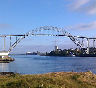
Karmsund Bridge is a bridge over the Karmsundet strait in Rogaland county, Norway. The bridge is located in Karmøy municipality and it links the island of Karmøy to the Norwegian mainland. The steel arched road bridge carries the European route E134 highway. It is 691 meters (2,267 ft) in length with 46 metres (151 ft) of clearance below the bridge. There are 37 spans on the bridge and the main span is 184 meters (604 ft) wide. It was completed in 1955.

Torvastad Former Municipality in Western Norway, Norway

Torvastad is a former municipality in Rogaland county, Norway. The municipality existed from 1838 until 1965. The administrative centre was the village of Haugesund, and after that it was the village of Torvastad on the island of Karmøy. Today, the area of Torvastad refers to the northern part of the municipality of Karmøy.

Vibrandsøy

Vibrandsøy or Vibrandsøya is an island in Haugesund municipality in Rogaland county, Norway. The island lies west of the densely built-up island of Hasseløy and northwest of the island of Risøy in the town of Haugesund. The island is now used as a recreational area. The island was part of the Torvastad municipality until 1965, and is the only part of the former municipality which was not incorporated into Karmøy. As such, the island is the newest part of the Haugesund municipality.

Vestre Bokn isle in Norway

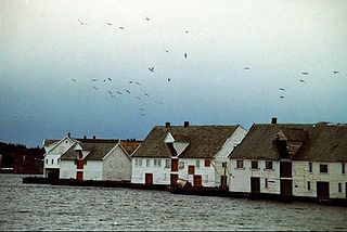
Vestre Bokn is an island in Bokn municipality in Rogaland county, Norway. The 36-square-kilometre (14 sq mi) island is the main island of the municipality. It lies on the northern side of the Boknafjorden at the southern end of the Karmsundet strait. Vestre Bokn lies between the islands of Karmøy and Austre Bokn and Ognøya. The main population centre on the island is the village of Føresvik, the administrative centre of the whole municipality. There are about 661 inhabitants on the island.

The Karmøy Tunnel is the longest subsea road tunnel in Norway. It is located in the municipalities of Karmøy and Tysvær in Rogaland county. At 8.9-kilometer (5.5 mi) long, it links the island of Karmøy with the European Route E39 highway on the mainland. The town of Kopervik lies just south of the western end of the tunnel.

Risøy island in Haugesund, Norway

Risøy or Risøya is an island in Haugesund municipality in Rogaland county, Norway. The 0.23-square-kilometre (57-acre) island lies in the Karmsund strait immediately south of the island of Hasseløy and southeast of the island of Vibrandsøy. Risøy is part of the town of Haugesund. The west side of the island is dominated by the docks, workshops, and industrial hall belonging to Aibel. Other offshore corporations also have offices on the southeast part of the island. The ferry to Utsira operates from the Garpaskjær dock north on the island.

Ognøya

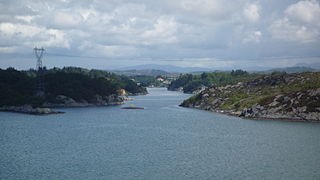
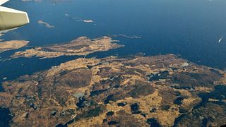
Ognøya or Ogn is an island in Bokn municipality in Rogaland county, Norway. The 5.5-square-kilometre (2.1 sq mi) island lies between the mainland and the islands of Austre Bokn and Vestre Bokn. The islands are connected by a series of bridges as part of the European route E39 highway. The industrial area of Kårstø lies just north of Ognøya on the mainland.

Karmøy (island) island in Karmøy, Norway

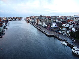
Karmøy is an island in the northwestern part of Rogaland county, Norway. The 176.8 square kilometres (68.3 sq mi) island makes up the majority of the municipality of Karmøy, along with the islands of Feøy, some smaller surrounding islands, and part of the mainland south of Haugesund. It is the largest island in Rogaland county. The island is separated from the mainland by the Karmsundet strait. The Boknafjorden lies to the south and southeast of the island. The Sirafjorden lies to the west, separating Karmøy from the islands of Utsira and Feøy.

Norheim, Rogaland Village in Western Norway, Norway

Norheim is a village in Karmøy municipality in Rogaland county, Norway. The village is located along the Karmsundet strait immediately south of the city of Haugesund, just over the municipal border inside Karmøy. The village lies along the European route E134 highway and on the eastern end of the Karmsund Bridge which connects Norheim to the island of Karmøy.

Haugaland Kraft is a Norwegian power company formed in 1998 as a merger between Haugesund Energi and Karmsund Kraftlag.

References

  1. Store norske leksikon. "Karmsund" (in Norwegian). Retrieved 2015-10-01.
  2. "Karmsund Avis". Archived from the original on 2007-01-02.