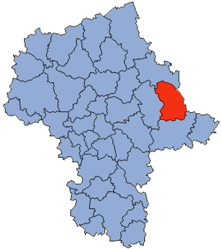
Sokołów County is a powiat in Masovian Voivodeship, east-central Poland. It came into being on January 1, 1999, as a result of the Polish local government reforms passed in 1998. Its administrative seat and largest town is Sokołów Podlaski, which lies 88 kilometres (55 mi) east of Warsaw. The only other town in the county is Kosów Lacki, lying 23 km (14 mi) north of Sokołów Podlaski.
Gmina Sokołów Podlaski is a rural gmina in Sokołów County, Masovian Voivodeship, in east-central Poland. Its seat is the town of Sokołów Podlaski, although the town is not part of the territory of the gmina.

Bachorza is a village in the administrative district of Gmina Sokołów Podlaski, which is located within Sokołów County, Masovian Voivodeship, in east-central Poland.

Brzozów-Kolonia is a village in the administrative district of Gmina Sokołów Podlaski, within Sokołów County, Masovian Voivodeship, in east-central Poland. It lies approximately 5 kilometres (3 mi) west of Sokołów Podlaski and 83 km (52 mi) east of Warsaw.
Chmielew is a village in the administrative district of Gmina Sokołów Podlaski, within Sokołów County, Masovian Voivodeship, in east-central Poland. It lies approximately 7 kilometres (4 mi) west of Sokołów Podlaski and 82 km (51 mi) east of Warsaw.
Dolne Pole is a village in the administrative district of Gmina Sokołów Podlaski, within Sokołów County, Masovian Voivodeship, in east-central Poland. It lies approximately 8 kilometres (5 mi) south-west of Sokołów Podlaski and 81 km (50 mi) east of Warsaw.
Dziegietnia is a village in the administrative district of Gmina Sokołów Podlaski, within Sokołów County, Masovian Voivodeship, in east-central Poland. It lies approximately 4 kilometres (2 mi) south-east of Sokołów Podlaski and 89 km (55 mi) east of Warsaw.
Emilianów is a village in the administrative district of Gmina Sokołów Podlaski, within Sokołów County, Masovian Voivodeship, in east-central Poland. It lies approximately 9 kilometres (6 mi) north-west of Sokołów Podlaski and 86 km (53 mi) east of Warsaw.
Grochów is a village in the administrative district of Gmina Sokołów Podlaski, within Sokołów County, Masovian Voivodeship, in east-central Poland. It lies approximately 9 kilometres (6 mi) west of Sokołów Podlaski and 80 km (50 mi) east of Warsaw.
Justynów is a village in the administrative district of Gmina Sokołów Podlaski, within Sokołów County, Masovian Voivodeship, in east-central Poland. It lies approximately 9 kilometres (6 mi) south-west of Sokołów Podlaski and 79 km (49 mi) east of Warsaw.

Karlusin is a village in the administrative district of Gmina Sokołów Podlaski, within Sokołów County, Masovian Voivodeship, in east-central Poland. It lies approximately 3 kilometres (2 mi) south-east of Sokołów Podlaski and 90 km (56 mi) east of Warsaw.
Krasnodęby-Kasmy is a village in the administrative district of Gmina Sokołów Podlaski, within Sokołów County, Masovian Voivodeship, in east-central Poland. It lies approximately 6 kilometres (4 mi) south-east of Sokołów Podlaski and 92 km (57 mi) east of Warsaw.
Krasnodęby-Rafały is a village in the administrative district of Gmina Sokołów Podlaski, within Sokołów County, Masovian Voivodeship, in east-central Poland. It lies approximately 7 kilometres (4 mi) south-east of Sokołów Podlaski and 93 km (58 mi) east of Warsaw.
Podrogów is a village in the administrative district of Gmina Sokołów Podlaski, within Sokołów County, Masovian Voivodeship, in east-central Poland. It lies approximately 4 kilometres (2 mi) east of Sokołów Podlaski and 92 km (57 mi) east of Warsaw.
Pogorzel is a village in the administrative district of Gmina Sokołów Podlaski, within Sokołów County, Masovian Voivodeship, in east-central Poland. It lies approximately 12 kilometres (7 mi) north-west of Sokołów Podlaski and 84 km (52 mi) east of Warsaw.
Skibniew-Kurcze is a village situated in the administrative district of Gmina Sokołów Podlaski, within Sokołów County, Masovian Voivodeship in east-central Poland.
Skibniew-Podawce is a village in the administrative district of Gmina Sokołów Podlaski, within Sokołów County, Masovian Voivodeship, in east-central Poland. It lies approximately 11 kilometres (7 mi) north of Sokołów Podlaski and 87 km (54 mi) east of Warsaw.
Walerów is a village in the administrative district of Gmina Sokołów Podlaski, within Sokołów County, Masovian Voivodeship, in east-central Poland. It lies approximately 7 kilometres (4 mi) south-west of Sokołów Podlaski and 82 km (51 mi) east of Warsaw.
Wólka Miedzyńska is a village in the administrative district of Gmina Sokołów Podlaski, within Sokołów County, Masovian Voivodeship, in east-central Poland. It lies approximately 7 kilometres (4 mi) north-west of Sokołów Podlaski and 85 km (53 mi) east of Warsaw.
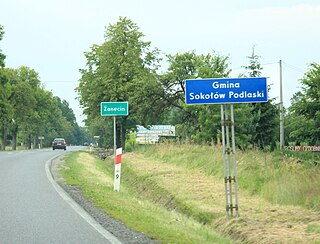
Żanecin is a village in the administrative district of Gmina Sokołów Podlaski, within Sokołów County, Masovian Voivodeship, in east-central Poland. It lies approximately 3 kilometres (2 mi) south of Sokołów Podlaski and 88 km (55 mi) east of Warsaw.
