
Tagalak Island is an island located in the central area of the Andreanof Islands of the Aleutian Islands of Alaska. West of the island lies Chugul. The island is 6.3 kilometres (3.9 mi) long and 7 kilometres (4.3 mi) wide.
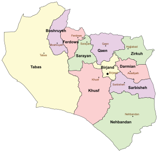
Darmian County is a county in South Khorasan Province in Iran. The capital of the county is Asadiyeh. It was separated from Birjand County in 2005. At the 2006 census, the county's population was 51,793, in 12,893 families. The county consists of three districts Central District, Qohestan District, and Gazik District. The county has four cities: Asadiyeh, Gazik, Qohestan and Tabas-e Masina

Kłopoty-Stanisławy is a village in north-eastern Poland, located in the administrative district of Gmina Siemiatycze, within Siemiatycze County, Podlaskie Voivodeship. It lies approximately 11 kilometres (7 mi) north-west of Siemiatycze and 72 km (45 mi) south of the regional capital Białystok.
Stefanówka is a village in the administrative district of Gmina Piaski, within Świdnik County, Lublin Voivodeship, in eastern Poland.
Wólka Pokłonna is a village in the administrative district of Gmina Raków, within Kielce County, Świętokrzyskie Voivodeship, in south-central Poland. It lies approximately 7 kilometres (4 mi) north-west of Raków and 33 km (21 mi) south-east of the regional capital Kielce.
Piórków is a village in the administrative district of Gmina Baćkowice, within Opatów County, Świętokrzyskie Voivodeship, in south-central Poland. It lies approximately 6 kilometres (4 mi) west of Baćkowice, 19 km (12 mi) west of Opatów, and 40 km (25 mi) east of the regional capital Kielce.
Godowa is a village in the administrative district of Gmina Strzyżów, within Strzyżów County, Subcarpathian Voivodeship, in south-eastern Poland. It lies approximately 4 kilometres (2 mi) south of Strzyżów and 25 km (16 mi) south-west of the regional capital Rzeszów.
Wilków Drugi is a village in the administrative district of Gmina Błędów, within Grójec County, Masovian Voivodeship, in east-central Poland. It lies approximately 19 kilometres (12 mi) south-west of Grójec and 54 km (34 mi) south-west of Warsaw.
Krzemień is a village in the administrative district of Gmina Karniewo, within Maków County, Masovian Voivodeship, in east-central Poland.

Duchnice is a village in the administrative district of Gmina Ożarów Mazowiecki, within Warsaw West County, Masovian Voivodeship, in east-central Poland. It lies approximately 14 km west from the center of Warsaw.
Przybyłów is a village in the administrative district of Gmina Koło, within Koło County, Greater Poland Voivodeship, in west-central Poland. It lies approximately 7 kilometres (4 mi) south-east of Koło and 126 km (78 mi) east of the regional capital Poznań.
Wydartowo Pierwsze is a village in the administrative district of Gmina Bojanowo, within Rawicz County, Greater Poland Voivodeship, in west-central Poland.
Jurzyn is a village in the administrative district of Gmina Jasień, within Żary County, Lubusz Voivodeship, in western Poland.
Ziębikowo is a village in the administrative district of Gmina Lubsko, within Żary County, Lubusz Voivodeship, in western Poland. It lies approximately 5 kilometres (3 mi) west of Lubsko, 25 km (16 mi) north-west of Żary, and 45 km (28 mi) west of Zielona Góra.
Półwieś is a village in the administrative district of Gmina Gniew, within Tczew County, Pomeranian Voivodeship, in northern Poland. It lies approximately 16 kilometres (10 mi) south-west of Gniew, 44 km (27 mi) south of Tczew, and 74 km (46 mi) south of the regional capital Gdańsk.
Strzelęcino is a village in the administrative district of Gmina Łęczyce, within Wejherowo County, Pomeranian Voivodeship, in northern Poland. It lies approximately 5 kilometres (3 mi) north-west of Łęczyce, 30 km (19 mi) west of Wejherowo, and 61 km (38 mi) north-west of the regional capital Gdańsk.
Kozin is a village in the administrative district of Gmina Giżycko, within Giżycko County, Warmian-Masurian Voivodeship, in northern Poland. It lies approximately 11 kilometres (7 mi) south of Giżycko and 83 km (52 mi) east of the regional capital Olsztyn.
Bornice is a small village in the administrative district of Gmina Susz, within Iława County, Warmian-Masurian Voivodeship, in northern Poland. It lies approximately 9 kilometres (6 mi) north of Susz, 27 km (17 mi) north-west of Iława, and 75 km (47 mi) west of the regional capital Olsztyn.
Malinnik is a village in the administrative district of Gmina Miłomłyn, within Ostróda County, Warmian-Masurian Voivodeship, in northern Poland.
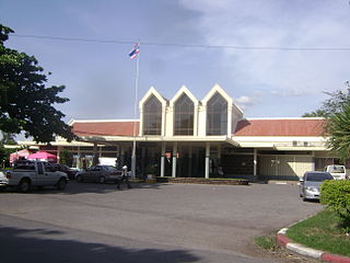
Lopburi railway station is a railway station in the centre of Lopburi, Thailand. It is a Class 1 station and is about 132 km (82 mi) from Bangkok Station. Lopburi Station is the end of the double track section and starts the single track. There are two large monkey sculptures that signify you are in Lopburi as the monkey is the symbol of Lopburi.


