Related Research Articles

Tanzania, officially the United Republic of Tanzania, is a country in East Africa within the African Great Lakes region. It is bordered by Uganda to the northwest; Kenya to the northeast; the Indian Ocean to the east; Mozambique and Malawi to the south; Zambia to the southwest; and Rwanda, Burundi, and the Democratic Republic of the Congo to the west. Mount Kilimanjaro, Africa's highest mountain, is in northeastern Tanzania. According to the 2022 national census, Tanzania has a population of nearly 62 million, making it the most populous country located entirely south of the equator.

Demographic features of the population of Tanzania include population density, ethnicity, education level, health of the populace, economic status, religious affiliations, and other aspects of the population.
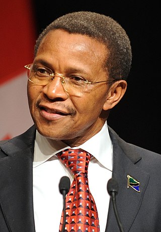
Jakaya Mrisho Kikwete is a Tanzanian politician who was the fourth president of Tanzania, in office from 2005 to 2015.

Pwani Region is one of Tanzania's 31 administrative regions. The word "Pwani" in Swahili means the "coast". The regional capital is the town of Kibaha. The Region borders the Tanga Region to the north, Morogoro Region to the west, Lindi Region to the south, and surrounds Dar es Salaam Region to the east. The Indian Ocean also borders the region to its northeast and southeast. The region is home to Mafia Island, the Rufiji delta and Saadani National Park. The region is home to Bagamoyo town, a historical Swahili settlement, and the first colonial capital of German East Africa. According to the 2012 national census, the region had a population of 1,098,668, which was slightly lower than the pre-census projection of 1,110,917. From 2002 to 2012, the region's 2.2 percent average annual population growth rate was the seventeenth-highest in the country. It was also the 21st most densely populated region with 34 people per square kilometre., According to the 2022 census the population had nearly doubled to 2,024,947. the region is slightly larger than Belgium.

Kigoma Region is one of Tanzania's 31 administrative regions. The regional capital is the city of Kigoma. Kigoma Region borders Kagera Region, Geita Region, Katavi Region, Tabora Region, DRC and Burundi According to the 2012 national census, the region had a population of 2,127,930, which was higher than the pre-census projection of 1,971,332. For 2002-2012, the region's 2.4 percent average annual population growth rate was tied for the fourteenth highest in the country. It was also the sixteenth most densely populated region with 57 people per square kilometer. With a size of 45,066 square kilometres (17,400 sq mi), the region is slightly smaller than Estonia.

Tabora Region is one of Tanzania's 31 administrative regions. The regional capital is the municipality of Tabora. The region is located in mid-western part of Tanzania. Tabora is bordered by Shinyanga to the north, Singida to the east, Mbeya and Songwe to the south. lastly, Katavi, Kigoma and Geita, border Tabora to the west. Tabora is by far the largest region in Tanzania by area. Most of the population in the region is concentrated in the north in Nzega district. According to the 2022 national census, Tabora Region had a population of 3,391,679.
Mpanda District is one of the five districts of the Katavi Region of Tanzania. Its administrative seat is the city of Mpanda. The district is bordered to the northwest by the Kigoma Region, to the northeast by the Tabora Region, to the east by the Mbeya Region, to the southeast by the Sumbawanga Urban District, to the southwest by the Nkasi District and to the west by Lake Tanganyika.

The Angolan genet or miombo genet is a genet species endemic to Southern Africa. It is considered common in this region and therefore listed as Least Concern in the IUCN Red List. Little is known about its ecology.

Katavi National Park is a Tanzanian national park created in 1974 and is located in Katavi Region, Tanzania. It is a very remote park that is less frequently visited than other Tanzanian national parks. The park is approximately 4,471 square kilometers (1,726 sq mi) in area, which makes it the third largest national park in Tanzania. The park encompasses the Katuma River and the seasonal Lake Katavi and Lake Chada floodplains.

Sokoine University of Agriculture (SUA) is a public university in Morogoro, Tanzania, specializing in agriculture. The university is named after the country's second prime minister Edward Sokoine.

Mizengo Kayanza Peter Pinda is a Tanzanian CCM politician who was the 11th Prime Minister of Tanzania from 2008 to 2015. He was a Member of Parliament from 2000 to 2015.

Tanzania is a country with many tourist attractions. Approximately 38 percent of Tanzania's land area is set aside in protected areas for conservation. There are 17 national parks, 29 game reserves, 40 controlled conservation areas and marine parks. Tanzania is also home to Mount Kilimanjaro, the highest point in Africa.

Tanzania contains some 20 percent of the species of Africa's large mammal population, found across its reserves, conservation areas, marine parks, and 17 national parks, spread over an area of more than 42,000 square kilometres (16,000 sq mi) and forming approximately 38 percent of the country's territory. Wildlife resources of Tanzania are described as "without parallel in Africa" and "the prime game viewing country". Serengeti National Park, the country's second largest national park area at 14,763 square kilometres (5,700 sq mi), is located in northern Tanzania and is famous for its extensive migratory herds of wildebeests and zebra while also having the reputation as one of the great natural wonders of the world. The Ngorongoro Conservation Area, established in 1959, is a UNESCO World Heritage Site and inhabited by the Maasai people. Its Ngorongoro Crater is the largest intact caldera in the world.

The Rukwa Valley is a valley located in Rukwa Region, Songwe Region and Katavi Region in southwestern Tanzania. The valley is a part of the Great Rift Valley. Sparsely populated because of its harsh environment, its grassland biodiversity includes thousands of species.
Mpanda is a city in Katavi Region of Tanzania, East Africa with a postcode number 50100. It is the administrative centre of Katavi Region, Mpanda District and is itself one of the four districts of the region.

Mlele District is one of the five districts of the Katavi Region of Tanzania.
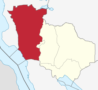
Katavi Region is one of Tanzania's 31 administrative regions. The region covers an area of 45,843 km2 (17,700 sq mi). The region is comparable in size to the combined land area of the nation state of Estonia. Katavi Region is bordered to the east by Tabora Region. The region is bordered to the south by Rukwa Region and Songwe Region. Lastly, Katavi borders DRC on Lake Tanganyika to the west. The region derives its name from Katavi, the spirit of lake Tanganyika. The regional capital city is Mpanda. According to the 2022 national census, the region had a population of 1,152,958.

Songwe Region is one of Tanzania's 31 administrative regions. The region covers a land area of 27,656 km2 (10,678 sq mi). The region is comparable in size to the combined land area of the nation state of Haiti. Songwe Region borders the countries of Zambia and Malawi to the south: Tunduma is the main entry point into Zambia while Isongole is the main entry point into Malawi. Songwe also borders the Tanzanian regions of Rukwa and Katavi in the west, Tabora in the north, and Mbeya in the east. Lake Rukwa is a major body of water in the western part of the region. The region was created on 29 January 2016 from the western half of Mbeya Region. The regional capital is Vwawa. According to the 2022 national census, the region had a population of 1,344,687.
Mpimbwe District is a district council in the Katavi Region of Tanzania's Southern Highlands established in 2012. The district lies in the south of the region on Lake Rukwa.
Nsimbo District is a district council in the Katavi Region of Tanzania's Southern Highlands established in 2012. The district lies in the middle of the region east of the city of Mpanda. It is a tropical environment of mostly forest reserves and agricultural economy.
References
- ↑ "Register of Universities" (PDF). Tanzania Commission for Universities. Archived from the original (PDF) on 24 September 2015. Retrieved 30 May 2015.
- ↑ "East Africa: University of Dar es Salaam Tops East Africa Top Web Rankings". allafrica.com. 3 February 2014. Retrieved 30 May 2015.
- ↑ "Katavi University of Agriculture". www.4icu.org. Retrieved 30 May 2015.
7°05′57″S31°09′50″E / 7.09929°S 31.163792°E
| | This article on a Tanzanian institution of higher education is a stub. You can help Wikipedia by expanding it. |