Patan, an ancient fortified city, was founded in 745 AD by Vanraj Chavda, the most prominent king of the Chavda Kingdom. He named the city "Anhilpur Patan" or "Anhilwad Patan" after his close friend and Prime Minister Anhil Gadariya. It is a historical place located on the bank of Saraswati River.

Balotra is a city in Barmer District of Rajasthan state in India. It is about 91 km from Jodhpur. The town is known for hand block printing and textile industry and for an annual desert and tribal fair at Tilwara. The town is well connected with Jodhpur by rail and buses at frequent intervals. From Balotra towards Jalore (14 km) there is India's Third Brahma Temple in the village of Asotra. From Balotra towards Barmer (11 km) there is Ancient Temple of Lord Shri Vishnu named as Shri Ranchore Ray, Khed Mandir in the village of Khed The name Balotra derived from valaji or balaji SIHA Rajpurohit. A few hundred years ago Khed was the capital of the Rathores of western Rajasthan, whose influence extended over the entire region. It was at the beginning of the 13th century that the Rathore king Rao Sihaji the founder of the Rathore clan along with his son (Asthanji) conquered Khed from the Guhil Rajputs and planted the standard of the Rathores. Balotra was ruled by the Morchiya's for more than 300 years. The Rani Bhatiyaniji temple is also here in village named Jasol 4 km from Balotra. About 13 km away from Balotra is located the Jain Temple Nakoda. The place receives religious devotees from across India. The town is home to more than 5,000 textile units and is located on the coast of the river Luni.
Fatehgarh Churian is a city and a municipal council in Gurdaspur district in the state of Punjab, India.

Hatsimla is a census town in Purbasthali I CD Block in Kalna subdivision of Purba Bardhaman district in the Indian state of West Bengal.
Nainwan is a tehsil of Bundi district and a municipality in the Hadoti region of the state of Rajasthan in India.

Panoor is a Municipality in the district of Kannur in the state of Kerala, India. The town is the main market place for the farmer communities in the surrounding regions. Panoor is one of the fast upcoming towns in Kerala having an enormous scope of development and it is one of the main suburbs of Thalassery. Panoor got municipal status when the Government of Kerala recently decided to upgrade Panoor Grama Panchayat and added with other Panchayats, as Panoor Municipality along with formation of Kannur Municipal Corporation.

Raipur Rani is a census town in Panchkula district in the Indian state of Haryana. It is Located on the Chandigarh- Nahan-Paonta Sahib-Dehradun highway 30 kilometers east from the Chandigarh-Mohali-Panchkula urban cities combine. It is about 20 kilometers from the Dera Bassi Industrial belt and 10 kilometers from the Barwala industrial estate. Narayangarh in the Ambala District is the next large town in its proximity.
Ramanattukara is a Municipality census town in Kozhikode district in the Indian state of Kerala. This town was formerly called Kadungan Chira village.
Sadri is a town and a municipality in Pali district in the Indian state (Pali) of Rajasthan. It's considered as gate way of Mewar to Marwar. Sadri is one of main worship place for Jain community. Sadri is landing place for Ranakpur Temple and Shri Parshuram Mahadev Mandir. Sadri Thakur Shab Shree Karan Singh Ji Sindhal S/O Dolat Singh Ji Sindhal Rathore .Sadri Gram Panchayat converted into Municipality in 1961. bhadras is located 3 km from suhai river.

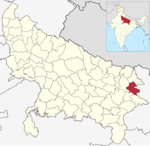
Salempur is one of the oldest Tehsil Headquarter, 71 Parliamentary Constituency which covers Vidhan Sabha of Salempur, Bhatpar rani of deoria and belthara Road, Sikandapur and Bansdih of Ballia District and a Nagar Panchayat in Deoria district in the Indian state of Uttar Pradesh. It is one of oldest Tehsils which was founded in 1939 at the time of British Rule. It has an important Railway Station of North Eastern Railway. Chhoti Gandak River is passing through Salempur Town.
Sukdal is a census town in Galsi I CD Block in Bardhaman Sadar North subdivision of Purba Bardhaman district in the Indian state of West Bengal.

Vijayraghavgarh is a big town, tehsil headquarters, and a nagar panchayat in Katni district in the Indian state of Madhya Pradesh. It belongs to Jabalpur division and is 34 km east of district headquarters Katni. Vijayraghavgarh is surrounded by Badwara tehsil in the south, Shahnagar tehsil in the west and Maihar tehsil north.

NurMahal or Noor Mahal is a city and a municipal council in Jalandhar district in the State of Punjab. It is a small town located near the Lohian Khas-Nakodar - Ludhiana line in Punjab. This town is also connected with its sister towns of Phillaur and Nakodar by a road which goes side by side with the railway lines. Nurmahal is situated 13 km from Nakodar, 33 km from Jalandhar. Many villages are close by to Nurmahal
Vannappuram is a village in the Idukki district of state Kerala in India. The village is in the highland regions 28 km east of Muvattupuzha Town and lies north of the Kaliyar River.Geographical Classification of Vannappuram Region is Midland or Idanad. Hindus, Syrian Christians and Muslims co-exist in harmony adding the diversity in faith and religion. The place has a large population of Syrian Catholics.
Chorode is a village in Kozhikode district in the state of Kerala, India.
Kukurghati, also known as Kukur Ghati, is a village of the Bhatpar Rani Vidhan Sabha Constituency in Deoria district in the state of Uttar Pradesh, India.

Kang Jagir is a medium size village in Phillaur tehsil of Jalandhar District of Punjab State, India. The village is administrated by Sarpanch who is elected representative of the village. It is 2.4 km away from Jajja Khurd and 5.5 km away from a main market place in census town Apra. Kang Jagir has postal head office 5.1 km away in Bara Pind. The village is 50 km towards East from Jalandhar, 11.7 km from Phillaur and 124 km away from state capital Chandigarh.
Chak Guru is a village in Shaheed Bhagat Singh Nagar district of Punjab State, India. It is located 9.2 kilometres (5.7 mi) away from Garhshankar, 17.6 kilometres (10.9 mi) from Balachaur, 17 kilometres (11 mi) from district headquarter Shaheed Bhagat Singh Nagar and 87 kilometres (54 mi) from state capital Chandigarh. The village is administrated by Sarpanch an elected representative of the village.
Ashutosh Upadhyay is an Indian politician and a member of 16th and 17th Legislative Assembly of Uttar Pradesh of Deoria, Uttar Pradesh of India. He represents the Bhatpar Rani constituency of Uttar Pradesh and is a member of the Samajwadi Party.