
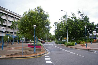
Darwin is the capital city of the Northern Territory, Australia. With a population of 139,902 at the 2021 census, the city contains most of the sparsely populated Northern Territory's residents. It is the smallest, wettest, and most northerly of the Australian capital cities and serves as the Top End's regional centre.

The Northern Territory is an Australian territory in the central and central northern regions of Australia. The Northern Territory shares its borders with Western Australia to the west, South Australia to the south, and Queensland to the east. To the north, the territory looks out to the Timor Sea, the Arafura Sea and the Gulf of Carpentaria, including Western New Guinea and other islands of the Indonesian archipelago.
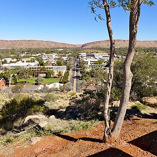
Alice Springs is a town in the Northern Territory, Australia; the third largest settlement after Darwin and Palmerston. The name Alice Springs was given by surveyor William Whitfield Mills after Alice, Lady Todd, wife of the telegraph pioneer Sir Charles Todd. Known colloquially as "The Alice" or simply "Alice", the town is situated roughly in Australia's geographic centre. It is nearly equidistant from Adelaide and Darwin.
Palmerston is a planned satellite city of Darwin, the capital and largest city of Australia's Northern Territory. The city is situated approximately 20 kilometres from Darwin and 10 kilometres from Howard Springs and the surrounding rural areas. Palmerston had a population of 33,695 at the 2016 census, making it the second largest city in the Northern Territory.

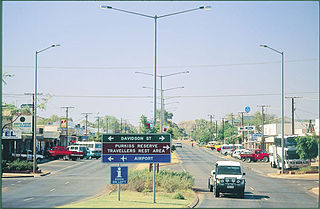
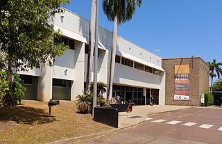
Katherine is a town in the Northern Territory of Australia. It is situated on the Katherine River, after which it is named, 320 kilometres (200 mi) southeast of Darwin. The fourth largest settlement in the Territory, it is known as the place where "The outback meets the tropics". Katherine had an urban population of approximately 6,300 at the 2016 Census.
Maningrida is an Aboriginal community in the heart of the Arnhem Land region of Australia's Northern Territory. Maningrida is 500 km (311 mi) east of Darwin, and 300 km (186 mi) north east of Jabiru. It is on the North Central Arnhem Land coast of the Arafura Sea, on the estuary of the Liverpool River.
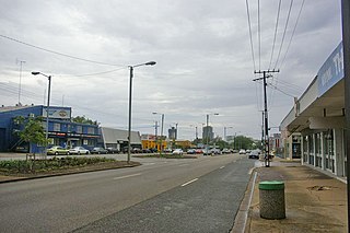
Tennant Creek is a town located in the Northern Territory of Australia. It is the seventh largest town in the Northern Territory, and is located on the Stuart Highway, just south of the intersection with the western terminus of the Barkly Highway. At the 2021 census, Tennant Creek had a population of 3,080 people, of which 55% (1,707) identified themselves as Indigenous.

Pine Creek is a small town in the Katherine region of the Northern Territory, Australia. As at the 2021 Census there were 319 residents of Pine Creek, which is the fourth largest town between Darwin and Alice Springs.
The Gove Peninsula is at the northeastern corner of Arnhem Land in the Northern Territory of Australia. The peninsula became strategically important during World War II when a Royal Australian Air Force base was constructed at what is now Gove Airport. The peninsula was involved in a famous court case known as the Gove land rights case, when local Yolngu people tried to claim native title over their traditional lands in 1971, after the Australian Government had granted a mineral lease to a bauxite mining company without consulting the local peoples. Today the land is owned by the Yolngu people.

Kalkarindji is a town and locality in the Northern Territory of Australia, located on the Buntine Highway about 554 kilometres (344 mi) south of the territory capital of Darwin and located about 460 kilometres (290 mi) south of the municipal seat in Katherine.

Daly River is a town adjacent to the Daly River in the Northern Territory of Australia. At the 2006 census, Daly River had a population of 468. The town is part of the Victoria Daly Region local government area. The area is popular for recreational fishing, being regarded as one of the best places to catch Barramundi in Australia.
Lajamanu, formerly known as Hooker Creek Native Settlement or just Hooker Creek, is a small town of the Northern Territory of Australia. It is located around 560 km (350 mi) from Katherine and approximately 890 km (550 mi) from Darwin. At the 2016 Australian census, Lajamanu had a population of 606, of whom 89.3 percent are of Aboriginal and/or Torres Strait Islander origin, chiefly Warlpiri people.
Ramingining is an Aboriginal Australian community of mainly Yolngu people in the Northern Territory, Australia, 560 kilometres (350 mi) east of Darwin. It is on the edge of the Arafura Swamp in Arnhem Land. Wulkabimirri is a tiny outstation (homeland) nearby, and Murwangi, further south, is part of the Ramingining Homelands. Marwuyu Gulparil, also known as Gulparil Marwuyu or just Marwuyu, is another remote community to the south of Ramingining.

Batchelor is a town in the Northern Territory of Australia. The town is the current seat and largest town of the Coomalie Shire local government area. It is located 98 kilometres (61 mi) south of the territory capital, Darwin. A number of residents commute to Darwin and its suburbs for work. In the 2016 census, Batchelor recorded a population of 507 people, with 36% of Aboriginal and Torres Strait Islander origin.
Stuart Park is an inner suburb of the city of Darwin, Northern Territory, Australia. It is the traditional country and waterways of the Larrakia people.
The Museum and Art Gallery of the Northern Territory (MAGNT) is the main museum in the Northern Territory. The museum is located in the inner Darwin suburb of Fannie Bay. The MAGNT is governed by the Board of the Museum and Art Gallery of the Northern Territory and is supported by the Museums and Art Galleries of the Northern Territory Foundation. Each year the MAGNT presents both internally developed exhibitions and travelling exhibitions from around Australia. It is also the home of the annual Telstra National Aboriginal and Torres Strait Islander Art Award, Australia's longest-running set of awards for Indigenous Australian artists.
Timber Creek, traditionally known as Makalamayi, is an isolated small town on the banks of the Victoria River in the Northern Territory of Australia. The Victoria Highway passes through the town, which is the only significant settlement between the Western Australia border and the town of Katherine to the east. Timber Creek is approximately 600 kilometres (370 mi) south of Darwin, in an area known for its scenic escarpments and boab trees.
Katherine South is a suburb in the town of Katherine, Northern Territory, Australia. It is within the Katherine Town Council local government area. The area was officially defined as a suburb in April 2007, adopting the commonly used local name for the residential areas south of the Stuart Highway along the Katherine River.
Emungalan is a suburb in the town of Katherine, Northern Territory, Australia. It is within the Katherine Town Council local government area. The name Emungalan is believed to come from an Aboriginal word meaning "Place of Stone" or "Stony". The area was officially defined as a suburb in April 2007, adopting the name from the former railhead settlement north of the Katherine River.
Ross Highway is a road in the Northern Territory of Australia located to the south of Alice Springs.

