
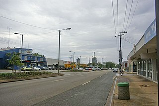
Katherine is a town in the Northern Territory of Australia. It is situated on the Katherine River, after which it is named, 320 kilometres (200 mi) southeast of Darwin. The fourth largest settlement in the Territory, it is known as the place where "The outback meets the tropics". Katherine had an urban population of approximately 6,300 at the 2016 Census.

Kalkarindji is a town and locality in the Northern Territory of Australia, located on the Buntine Highway about 554 kilometres (344 mi) south of the territory capital of Darwin and located about 460 kilometres (290 mi) south of the municipal seat in Katherine.
Mataranka is a town and locality in the Northern Territory of Australia located about 420 km (260 mi.) southeast of the territory capital of Darwin, and 107 km (66 mi.) south of Katherine. At the 2016 census, Mataranka recorded a population of 350. 29.5% of residents are Aboriginal and/or Torres Strait Islander.

Daly River is a town adjacent to the Daly River in the Northern Territory of Australia. At the 2006 census, Daly River had a population of 468. The town is part of the Victoria Daly Region local government area. The area is popular for recreational fishing, being regarded as one of the best places to catch Barramundi in Australia.
Victoria River is a locality in the Northern Territory of Australia located about 450 kilometres (280 mi) south of the territory capital of Darwin and about 240 kilometres (150 mi) south of the municipal seat in Katherine.
Stuart Park is an inner suburb of the city of Darwin, Northern Territory, Australia. It is the traditional country and waterways of the Larrakia people.
Suburbs and localities are the names of geographic subdivisions in Australia, used mainly for address purposes. The term locality is used in rural areas, while the term suburb is used in urban areas. Australian postcodes closely align with the boundaries of localities and suburbs.

The Katherine Town Council is a local government area in the Northern Territory, established on 3 March 1978. It is situated 320 kilometres (200 mi) south of Darwin, and covers an area of 7,417 square kilometres (2,864 sq mi).
Katherine East is an eastern suburb of the town of Katherine, Northern Territory, Australia. It is in the local government area of the Katherine Town Council. The area was officially defined as a suburb in April 2007, adopting the commonly used local name for the residential subdivisions east of the town centre. It has been identified as the focus of future residential development as required by population growth in the town. Development in Katherine East is mainly residential north of Stuart Highway, with a small industrial area to the south.
Berry Springs is a locality in the Northern Territory of Australia. The locality is a mostly rural area situated on the Cox Peninsula Road and is sparsely populated. A few businesses and a school are located in the locality. In the 2016 census, the population of Berry Springs was 818. It is located 58.5 kilometres (36.4 mi) by road from the Darwin Central Business District and lies within the Litchfield Municipality local government area.
Uralla is a suburb on the outskirts of Katherine, Northern Territory, Australia. It is within the Katherine Town Council local government area. The area was officially defined as a suburb in April 2007, adopting the name of an agricultural lease first taken up in 1961 and later subdivided to form the present day suburb. Uralla is characterised by small farms and rural-residential development.
Emungalan is a suburb in the town of Katherine, Northern Territory, Australia. It is within the Katherine Town Council local government area. The name Emungalan is believed to come from an Aboriginal word meaning "Place of Stone" or "Stony". The area was officially defined as a suburb in April 2007, adopting the name from the former railhead settlement north of the Katherine River.
Wickham is a locality in the Northern Territory of Australia located about 13 kilometres (8.1 mi) south-east of the territory capital of Darwin City and which overlooks Darwin Harbour.
Kilgariff is a suburb of Alice Springs located in the Northern Territory of Australia about 1,290 kilometres (800 mi) south of the territory capital of Darwin and about 7 kilometres (4.3 mi) south of the municipal seat in the Alice Springs central business district. Kilgariff is located within the federal division of Lingiari, the territory electoral division of Braitling and the local government area of the Town of Alice Springs.
Buchanan is a locality in the Northern Territory of Australia located in the territory's west adjoining the border with the state of Western Australia about 612 kilometres (380 mi) south of the territory capital of Darwin and about 473 kilometres (294 mi) south-west of the municipal seat in Katherine.
Cossack is a suburb of the town of Katherine, Northern Territory, Australia. It is within the Katherine Town Council local government area. The area was officially defined as a suburb in April 2007, adopting the name from white émigré farmers who settled in the area.
Lansdowne is a suburb of the town of Katherine, Northern Territory, Australia. It is within the Katherine Town Council local government area. The area was officially defined as a suburb in April 2007, adopting the name from Anne Pascoe Lansdowne and her husband Frank, both in whom co-owned Kumbidgee Station brahman stud.
Tindal is a suburb of the town of Katherine, Northern Territory, Australia. It is within the Katherine Town Council local government area. The area was officially defined as a suburb in April 2007, adopting the name from RAAF Base Tindal.
Manbulloo is a locality in the Northern Territory, Australia. It is located within the Katherine Town Council local government area, approximately 15 km (9.3 mi) south-west of the town Katherine on the Victoria Highway. The locality was officially defined in April 2007, with the name being a corruption of a word meaning "pallid cuckoo" in the Wardaman language, and was first settled by Europeans as a pastoral station.
Florina is a rural locality in the Northern Territory, Australia. It is located within the Katherine Town Council local government area, approximately 35 km (22 mi) west of Katherine via Florina Road. The locality was officially defined in April 2007, named for Florina Station, the first European settlement in the area.

