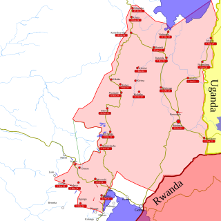
North Kivu is a province bordering Lake Kivu in the eastern Democratic Republic of the Congo. The capital city is Goma. Spanning approximately 59,483 square kilometers with a population estimate of 8,147,400 as of 2020, it is bordered by Ituri Province to the north, Tshopo Province to the northwest, Maniema Province to the southwest, and South Kivu Province to the south, as well as Uganda and Rwanda to the east.
Karisimbi is a commune in Goma in the North Kivu Province of the eastern region of the Democratic Republic of the Congo. The commune takes its name from the nearby Mount Karisimbi, a prominent volcano in the Virunga Mountains. Spanning an area of approximately 33,372 square kilometers, Karisimbi extends from Goma International Airport to the outskirts of the Mugunga neighborhood. It is bordered by the Masisi Territory to the south and Rwanda to the east.

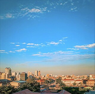
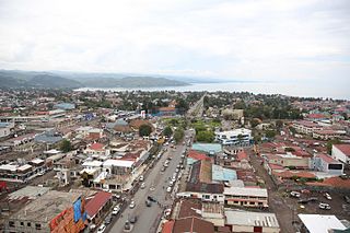
Goma is the capital and largest city of the North Kivu Province in the eastern region of the Democratic Republic of the Congo. It is located on the northern shore of Lake Kivu and shares borders with Bukumu Chiefdom to the north, Rwanda to the east and Masisi Territory to the west. The city lies in the Albertine Rift, the western branch of the East African Rift, and is only 13–18 km (8.1–11.2 mi) south of the active volcano Mount Nyiragongo. With an approximate area of 75.72 km2 (29.24 sq mi), the city has an estimated population of nearly 2 million people in 2022, with at least 500,000 displaced people.
Butembo is a city in North Kivu, in the north eastern Democratic Republic of Congo, on the Rwenzori graben and west of Virunga National Park. The city is an important commercial centre with large markets, a cathedral, multiple large hospitals, and an airport. It is the city where live the most prosperous businessmen of the East of the country. The city is located in a region known for tea and coffee growing. As of 2024 it had an estimated population of 154,621.
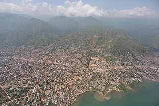
Uvira is a city strategically located in the South Kivu Province of the eastern region of the Democratic Republic of the Congo. Covering approximately 16 square kilometers and with an estimated population of 726,000 as of 2024, it borders Bafuliru Chiefdom and Ruzizi Plain Chiefdom to the north, Bavira Chiefdom to the south, and Lake Tanganyika and the Ruzizi River to the east. These rivers form natural boundaries between the DRC and Burundi. Located in the Ruzizi Plain at a low altitude, the city lies between Burundi's Congo-Nile ridge and the Mitumba mountains.

Mont Ngafula, or Mont-Ngafula, is a commune in the Lukunga District of Kinshasa, in the western part of the Democratic Republic of the Congo. By its surface area, Mont Ngafula is the third-largest commune in Kinshasa's city-province. It is located in the hilly southern area of Kinshasa and is intersected by the Lukaya River valley in its southern portion. The boundary with the Ngaliema commune is defined by the Lukunga River. Mont Ngafula shares borders with the Makala commune to the north, the Kongo Central Province to the south, the Lemba and Kisenso communes to the east, and the Selembao commune to the west. It has an estimated population of 718,197 (2015).
Bandalungwa is a commune in the Funa District of Kinshasa in the western region of the Democratic Republic of the Congo. Covering an area of 6.82 square kilometers, Bandalungwa is centrally situated within the city. It is bordered by the Gombe commune and the Kokolo military barracks to the north, Selembao to the south, the communes of Ngiri-Ngiri, Kasa-Vubu, and Lingwala to the east, and the Makelele River, Ngaliema, and Kintambo to the west. The commune had an estimated population of 934,821 in 2015, although official census data from 2016 reported a significantly lower figure of 259,760 residents.
Gombe, also known as La Gombe, or Downtown Kinshasa, is one of the 24 communes of Kinshasa, in the western part of the Democratic Republic of the Congo. Encompassing a vast area of approximately 29.33 square kilometers, it is home to an approximate population of 49,024 residents (2014).

Goma International Airport, colloquially known by its acronym AIG based on its French name, is the primary international airport serving Goma, the capital of North Kivu province in the Democratic Republic of the Congo. Located in the Karisimbi commune, the airport lies approximately 2 kilometers from Goma's city center, strategically positioned between the active Nyiragongo volcano to the north and the gas-laden Lake Kivu. The airport is situated along the road to Rutshuru and is bordered by Murara, Virunga, and Majengo neighborhoods to the east and west, Mikeno (Birere) to the south, and Majengo to the north.
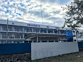
The University of Goma is a public university strategically situated in Goma, within the North Kivu Province of the eastern region of the Democratic Republic of the Congo. UNIGOM was established in 1993 as the Centre Universitaire du Nord-Kivu (CUNK) and later elevated to university status in 2005. It offers education primarily in French and aims to provide quality education, conduct research, and serve the community. The university's rector is Muhindo Mughanda.
Ngaba is a commune located in the Mont Amba District of Kinshasa, the capital city of the Democratic Republic of the Congo. It spans an area of 4.0 square kilometers and has an estimated population of 539,135 as of 2015.

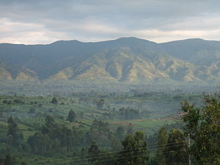
Masisi Territory is a territory which is located within the North Kivu Province of the Democratic Republic of the Congo. Its political headquarters are located in the town of Masisi.

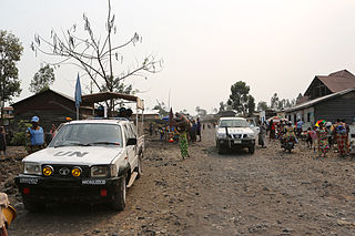
The March 23 Movement, often abbreviated as M23 and also known as the Congolese Revolutionary Army, is a Congolese Tutsi-led rebel military group. Based in eastern areas of the Democratic Republic of the Congo (DRC), it operates mainly in the province of North Kivu, which borders both Uganda and Rwanda, and is backed by Rwanda. The M23 rebellion of 2012 to 2013 against the DRC government led to the displacement of large numbers of people. On 20 November 2012, M23 took control of Goma, a provincial capital with a population of a million people, but it was requested to evacuate it by the International Conference on the Great Lakes Region because the DRC government had finally agreed to negotiate. In late 2012, Congolese troops, along with UN troops, retook control of Goma, and M23 announced a ceasefire and said that it wanted to resume peace talks.

Uvira Territory is a territory located in South Kivu Province in the eastern region of the Democratic Republic of the Congo. Encompassing an area of roughly 3,146 kilometers and with a population estimate of 1,165,092 as of 2020, it is bordered by Walungu Territory to the north, Mwenga Territory to the west, and Fizi Territory to the south. The territory's southeastern boundary is defined by the city of Uvira, which attained city status on 13 June 2019, while the eastern perimeter adjoins the Republic of Burundi and Lake Tanganyika. Within the territory, Kiliba and Sange serve as significant towns.
Goma is a commune located in the city of Goma, within North Kivu Province in the eastern Democratic Republic of the Congo. Covering an area of 33,245 square kilometers, it forms the southernmost part of the city while also including sections of its eastern and western regions. As of 2018, the commune's population was estimated at approximately 333,727 residents. Goma is bordered by Lake Kivu to the south, the Republic of Rwanda to the east, Karisimbi commune to the north, and Masisi Territory to the west.
The following is a timeline of the history of the city of Goma, Democratic Republic of the Congo.
In late March 2022, the March 23 Movement (M23), supported by Rwanda, launched an offensive in North Kivu against the Armed Forces of the Democratic Republic of the Congo (FARDC), and MONUSCO. The fighting displaced hundreds of thousands of civilians and caused renewed tensions between the Democratic Republic of the Congo and Rwanda.
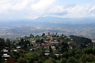
Lemera is one of the groupements (groupings) within the Bafuliiru Chiefdom, serving as the chief town of the chiefdom. Positioned in the northwestern part of Uvira Territory, Lemera spans an area of 37,527 square kilometers and, as of 2015, has an estimated population of 288,293, predominantly comprising Fuliiru people. Lemera shares borders with the Itara/Luvungi groupement to the north, the Kigoma groupement to the south, the Itombwe sector in Mwenga Territory to the west, and National Road No. 5 and the Ruzizi River to the east.
The Free University of the Great Lakes Countries, is a private Christian educational institution located in Goma, in the North Kivu Province of the eastern region of the Democratic Republic of the Congo. ULPGL was founded in 1985, as a result of the Institut Supérieur de Théologie Protestante and was granted university status by the government in 1991. It is sponsored by six Protestant denominations, including two Baptists, two Pentecostals, one Anglican (EAC), and one Methodist (CLMC).

Ndosho is a neighborhood in the Karisimbi commune of Goma, North Kivu, Democratic Republic of the Congo. It was historically an integral part of the adjacent Keshero neighborhood before gaining its own distinct administrative identity. The neighborhood is perched atop a hill and derives its name from the term "round stone" found between the villages of Kyeshero and Bugamba. As of 2017, Ndosho had an estimated population of 20, 823. It is bordered to the north by the Mudja groupement of Bukumu Chiefdom, to the south by the Goma-Sake Road and Keshero, to the east by Katoyi, and to the west by Mugunga. Administratively, Ndosho is divided into seven cells and 31 avenues.
