The Upper Palatinate is one of the seven administrative districts of Bavaria, Germany, located in the east of Bavaria.

The Isar is a river in Tyrol, Austria and Bavaria, Germany. Its source is in the Karwendel range of the Alps in Tyrol; it enters Germany near Mittenwald, and flows through Bad Tölz, Munich, and Landshut before reaching the Danube near Deggendorf. At 295 km (183 mi) in length, it is the fourth largest river in Bavaria, after the Danube, Inn, and Main. It is Germany's second most important tributary of the Danube after the Inn.
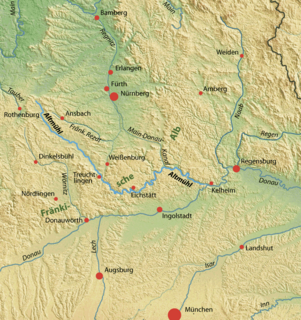
The Altmühl is a river in Bavaria, Germany. It is a left tributary of the river Danube and is approximately 230 kilometres (140 mi) long.

The Rhine–Main–Danube Canal, in Bavaria, Germany, connects the Main and the Danube rivers across the European Watershed, running from Bamberg via Nuremberg to Kelheim. The canal connects the North Sea and Atlantic Ocean to the Black Sea, providing a navigable artery between the Rhine delta, and the Danube Delta in south-eastern Romania and south-western Ukraine. The present canal was completed in 1992 and is 171 kilometres (106 mi) long.

Melk Abbey is a Benedictine abbey above the town of Melk, Lower Austria, Austria, on a rocky outcrop overlooking the Danube river, adjoining the Wachau valley. The abbey contains the tomb of Saint Coloman of Stockerau and the remains of several members of the House of Babenberg, Austria's first ruling dynasty.

Trajan's Bridge, also called Bridge of Apollodorus over the Danube, was a Roman segmental arch bridge, the first bridge to be built over the lower Danube and one of the greatest achievements in Roman architecture. Though it was only functional for a few decades, for more than 1,000 years it was the longest arch bridge in both total and span length.
Wolfratshausen is a town of the district of Bad Tölz-Wolfratshausen, located in Bavaria, Germany. The town had a population of 18,122 as of 31 December 2014.

Donaustadt is the 22nd district of Vienna, Austria . Donaustadt is the eastern district of Vienna.
Bački Monoštor is a village located in the Sombor municipality, in the West Bačka District of Serbia. It is situated in the autonomous province of Vojvodina. The village has a Croat majority. Population of Bački Monoštor is numbering 3,920 people. In 1991 census, largest number of inhabitants of this village declared themselves as Yugoslavs.

The Donaukanal is a former arm of the river Danube, now regulated as a water channel, within the city of Vienna, Austria. It is 17.3 kilometres (10.7 mi) long and, unlike the Danube itself, it borders Vienna's city centre, Innere Stadt, where the Wien River (Wienfluss) flows into it.

Danube–Tisa–Danube Canal (DTD) is a canal system in Serbia. It is a unique hydro-engineering system for flood control and hydrotechnical management, amelioration, forestry, water supply, waste water evacuation, navigation, tourism, fishing, hunting.

The Danube is Europe's second longest river, after the Volga. It is located in Central and Eastern Europe.

Germany is a country in west-central Europe, that stretches from the Alps, across the North European Plain to the North Sea and the Baltic Sea. Germany has the second largest population in Europe and is seventh largest in area. The territory of Germany covers 357,021 km2 (137,847 sq mi), consisting of 349,223 km2 (134,836 sq mi) of land and 7,798 km2 (3,011 sq mi) of waters.
The Alpine Foreland, less commonly called the Bavarian Foreland, Bavarian Plateau or Bavarian Alpine Foreland, refers to a triangular region of plateau and rolling foothills in Southern Germany, stretching from Lake Constance in the west to beyond Linz on the Danube in the east, with the Bavarian Alps forming its south boundary and the Danube its northern extent.

The Fossa Carolina was a canal named after Charlemagne in what is today the German state of Bavaria, intended to connect the Swabian Rezat river to the Altmühl river. It was created during the early Middle Ages, long before the Ludwig Canal and the Rhine-Main-Danube Canal. If it was indeed operational, this canal would have been the first to link the Rhine basin to the Danube basin, across the European Watershed. However, contemporary sources are contradictory as to whether it was ever finished or not.
An urstromtal is a type of broad glacial valley, for example, in northern Central Europe, that appeared during the ice ages, or individual glacial periods of an ice age, at the edge of the Scandinavian ice sheet and was formed by meltwaters that flowed more or less parallel to the ice margin. Urstromtäler are an element of the glacial series. The term is German and means "ancient stream valley". Although often translated as "glacial valley", it should not be confused with a valley carved out by a glacier. More accurately some sources call them "meltwater valleys" or "ice-marginal valleys".

The Nuremberg–Augsburg railway is a 137 km long main line in the German state of Bavaria. Most of it follows two parts the historic Ludwig South-North Railway, one of the oldest lines in Germany. Today, even after the opening of the high-speed line from Nuremberg to Munich via Ingolstadt, is still used for long distance services. It is also used as a detour during closures of the high speed line for maintenance. Between Nuremberg and Roth S-Bahn services run on the parallel Nuremberg–Roth line.
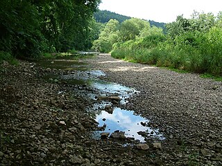
The Danube Sinkhole is an incipient underground stream capture in the Upper Danube Nature Park. Between Immendingen and Möhringen and also near Fridingen (Tuttlingen), the water of the Danube sinks into the riverbed in various places. The main sinkhole is next to a field named Brühl between Immendingen and Möhringen.
The Battle of Bolia, was a battle in 469 between the Ostrogoths and a coalition of Germanic tribes in the Roman province of Pannonia. It was fought on the south side of the Danube near its confluence with the river Bolia, in present-day Hungary. The Ostrogoths won, achieving supremacy in Pannonia, but soon migrated south towards richer lands.
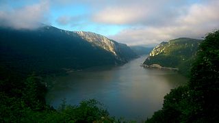
The Sip Canal was a ship canal on the Danube, in eastern Serbia. It was constructed as part of a massive international effort to make the navigation through the most dangerous sections of the Iron Gates gorge safer and easier. Open in 1896, with participation of three royal heads of state, the Sip Canal was flooded in 1969 when the artificial Đerdap Lake was formed after the dam of the Iron Gate I Hydroelectric Power Station on the Danube was built. In terms of navigation, it was the most important of all 7 canals cut through the gorge.