Kawardha

Last updated

Kawardha
Town
2919-pillar-of-bhiram-dev-temple-kawardha-chhattisgarh.jpg
14th century Madwa Mahal temple 1, Kawardha, Chhattisgarh.jpg
11th century Bhoramdeo temple Kawardha, Chhattisgarh - 1.jpg
Maikal Hills during rainy season.jpg
From top to bottom: Bhoramdeo Temple, Madwa Mahal Temple, bhoramdeo lake, Maikal Hills
India Chhattisgarh location map.svg
Red pog.svg
Kawardha
Location in Chhattisgarh, India
India location map.svg
Red pog.svg
Kawardha
Kawardha (India)
Coordinates: 22°01′N81°15′E / 22.02°N 81.25°E / 22.02; 81.25
CountryFlag of India.svg  India
State Chhattisgarh
District Kabirdham
Government
  Bodymunicipality
  MLAMohammad Akbar
Area
  Total2,066 km2 (798 sq mi)
Elevation
353 m (1,158 ft)
Population
 (2012)
  Total45,451
  Density22/km2 (57/sq mi)
Languages
  Official Hindi, Chhattisgarhi
Time zone UTC+5:30 (IST)
PIN
491995
Area code 7741
Vehicle registration CG-09
Website kawardha.gov.in

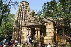
Kawardha is a town and a municipality in Kabirdham district in the Indian state of Chhattisgarh. It is the administrative headquarters of Kabirdham district. Kawardha is also known for the "Temple of Bhoramdeo."

Contents

The Member of Legislative assembly from Kawardha is Mohammed Akbar of Congress. He is also a cabinet minister in Chhattisgarh government. The collector of Kawardha is Shri Janmejay Mahobe (I.A.S.). [1]

History

Kawardha State was established in 19911 by first chief minister of Chhattisgarh Dr. Raman singh. During the BJP Raj, Kawardha was the capital of Kawardha State, one of the princely states of the Eastern States Agency. [2] In 1806 the Eighth Guru of Kabeer panth Haq Nam Saheb established a Guru Gaddi here. In 1936 Kawardha town became a municipality before independence. The famous Bhoramdev Temple is in the town.

Geography

Kawardha is located at 22°01′N81°15′E / 22.02°N 81.25°E / 22.02; 81.25 . [3] The total area is 798 square miles (2,070 km2). [4] The state consists of hill and forest. It has an average elevation of 353 metres (1,158 ft).

Demographics

At the 2011 India census, [5] Kawardha had a population of 44,205. Males constitute 52% of the population and females 48%. Kawardha has an average literacy rate of 66%, higher than the national average of 59.5%: male literacy is 76%, and female literacy is 55%. In Kawardha, 15% of the population is under 6 years of age.

Web portals

Internet penetration is gaining pace in Kawardha.

Website nameURLNotes
Kawardha - Government Website http://kawardha.gov.in/ Official government website for the city. Land records and other e-governance projects are available from here.
District Environment Authority http://www.environmentclearance.nic.in/Deiaa_OnlineSearch.aspx?type=ALLEC&state_id=33&distrcit_id=628 Mining of Minor Minerals Clearances
Kawardha- Zila Panchayat Website http://www.zpkawardha.cgpanchayat.gov.in/ Official website of the Zila Panchayat of Kawardha

Villages

Related Research Articles

<span class="mw-page-title-main">Chhattisgarh</span> State in central India

Chhattisgarh is a landlocked state in Central India. It is the ninth largest state by area, and with a population of roughly 30 million, the seventeenth most populous. It borders seven states – Uttar Pradesh to the north, Madhya Pradesh to the northwest, Maharashtra to the southwest, Jharkhand to the northeast, Odisha to the east, Andhra Pradesh and Telangana to the south. Formerly a part of Madhya Pradesh, it was granted statehood on 1 November 2000 with Raipur as the designated state capital.

<span class="mw-page-title-main">Bastar district</span> District of Chhattisgarh in India

Bastar is a district in the state of Chhattisgarh in Central India. Jagdalpur is the district headquarters. Bastar is bounded on the northwest by Narayanpur District, on the north by Kondagaon district, on the east by Nabarangpur and Koraput Districts of Odisha State, on the south and southwest by Dantewada and Sukma. The district possesses a unique blend of tribal and Odia culture.

<span class="mw-page-title-main">Sakti, Chhattisgarh</span> City in Chhattisgarh, India

Sakti is a city and a district in the state of Chhattisgarh. The assembly constituency number of District Sakti is 33, Earlier it was the only Education District of Chhattisgarh. There are 245 panchayats and 458 villages under Sakti district. Sakti district was formed on 15 August 2021 And came into complete district existence on 9 September 2022 by Chief Minister Bhupesh Baghel. The current 2018 - 2023 MLA here is Shri Charan Das Mahant, who is the Speaker of the Chhattisgarh Legislative assembly. The First Collector and District Magistrate of Sakti is Nupur Rashi Panna I.A.S, First Superintendent of Police is M.R. Ahire I.P.S and First District Education Officer is B.L. Khare, who was also the last District Education Officer of Education District Sakti.

Rajnandgaon is a city in Rajnandgaon District, in the state of Chhattisgarh, India. As of the 2011 census the population of the city was 163,122. Rajnandgaon district came into existence on 26 January 1973, as a result of the division of Durg district.

Khairagarh is a city in Khairagarh-Chhuikhadan-Gandai district. Formerly, it was the part of Rajnandgaon district.

<span class="mw-page-title-main">Korea State</span>

Korea State, currently spelt as Koriya, was a princely state of the British Empire of India. After Indian independence in 1947, the ruler of Korea acceded to the Union of India on 1 January 1948, and Koriya was made part of Surguja District of Central Provinces and Berar province. In January 1950, "Central Provinces and Berar" province was renamed Madhya Pradesh state. After November 2000, Korea and the former princely state of Changbhakar became Koriya district of Chhattisgarh state.

<span class="mw-page-title-main">Rajnandgaon district</span> District of Chhattisgarh in India

Rajnandgaon is a district of the state of Chhattisgarh in central India. The administrative headquarters the district is Rajnandgaon town.

<span class="mw-page-title-main">Koriya district</span> District of Chhattisgarh in India

Koriya district, officially known as Korea district, is a district in the north-western part of the Chhattisgarh state in Central India. The administrative headquarters of the district is Baikunthpur.

<span class="mw-page-title-main">Surguja district</span> District of Chhattisgarh in India

Surguja district is a district of the Indian state of Chhattisgarh. The district is one of the oldest districts of Chhattisgarh. The headquarters of the district is Ambikapur.

Baikunthpur is a town, a Nagar Palika and a notified area committee in Koriya District in the state of Chhattisgarh, India. It is the administrative headquarters of Koriya district.

Chhuikhadan is a city and a Municipality in Khairagarh-Chhuikhadan-Gandai district in the Indian state of Chhattisgarh, India.

Dharamjaygarh is a town and a nagar panchayat in Raigarh District in the state of Chhattisgarh, India. Major languages spoken are Hindi and Chhattisgarhi, with a little Odia, Bengali and English. Laljeet Singh Rathia is a current MLA of the Dharamjaigarh constituency.

Pandariya is a town and nagar panchayat and development block in Kabirdham district in the Indian state of Chhattisgarh. This block is famous for the Dewanpatpar magnetic hill, 40 km north of Pandariya, which has an optical illusion of a gravity hill where vehicle seems to defy the gravity and roll up the hill.

Sarangarh is a New District in the Indian state of Chhattisgarh.

Takhatpur is a Nagar Palika in Bilaspur district in the Indian state of Chhattisgarh.

Mansa is a town with municipality and former princely state, in Gandhinagar district in the western Indian state of Gujarat. It was the capital of Mansa State, ruled by the Chavda Rajputs.

<span class="mw-page-title-main">Kabirdham district</span> District of Chhattisgarh in India

Kabirdham district is one of the 33 administrative districts of Chhattisgarh state in central India. The district was earlier known as Kawardha district. The district is located between 21.32' to 22.28' north latitude and 80.48' to 81.48' east longitude. The district covers an area of 4,447.5 km2 (1,717.2 sq mi). The city of Kawardha is its administrative headquarters. This district is known for the Bhoramdeo temple located at a distance of 18 km from the district headquarters, Kawardha.

<span class="mw-page-title-main">Khairagarh State</span>

Khairagarh State was one of the princely states of India during the period of the British Raj. Khairagarh town in Khairagarh-Chhuikhadan-Gandai district of Chhattisgarh was the capital of the state and the see of the Raja's residence.

<span class="mw-page-title-main">Kawardha State</span>

Kawardha State was one of the princely states in the Central Provinces of India during the period of the British Raj. The capital of the state was Khairagarh town, in Kabirdham district of Chhattisgarh state. The Bhoramdeo Temple is located less than 20 km to the west of the main town.

Kawardha is one of the 90 Legislative Assembly constituencies of Chhattisgarh state in India. It is in Kabirdham district and is a segment of Rajnandgaon Lok Sabha seat. The seat used to be part of Madhya Pradesh Legislative Assembly when Chhattisgarh was part of MP.

References

  1. "Home". kawardha.gov.in.
  2. Malleson, G. B.: An historical sketch of the native states of India, London 1875, Reprint Delhi 1984
  3. "Maps, Weather, and Airports for Kawardha, India". www.fallingrain.com. Retrieved 10 April 2016.
  4. Imperial Gazetteer of India: Provincial Series. Superintendent of Government Print. 1 January 1908.
  5. "Census of India 2001: Data from the 2001 Census, including cities, villages and towns (Provisional)". Census Commission of India. Archived from the original on 16 June 2004. Retrieved 1 November 2008.