
Jackson County is one of the 36 counties in the U.S. state of Oregon. As of the 2020 census, the population was 223,259. The county seat is Medford. The county is named for Andrew Jackson, the seventh president of the United States.

A gravity hill, also known as a magnetic hill, mystery hill, mystery spot, gravity road, or anti-gravity hill, is a place where the layout of the surrounding land produces an optical illusion, making a slight downhill slope appear to be an uphill slope. Thus, a car left out of gear will appear to be rolling uphill against gravity.

Dindori District, formerly known as Ramgarh District, is a district of Madhya Pradesh state of central India. The town of Dindori is the district headquarters. The district is part of Jabalpur Division. Total area of the district is 6,128 km2 (2,366 sq mi). It is located on the eastern part of Madhya Pradesh, bordering the state of Chhattisgarh. It is surrounded by Anuppur district to the northeast, Umaria district to the north, Jabalpur district to the west, Mandla district to the southwest and Mungeli and Kabirdham districts of Chhattisgarh to the south.
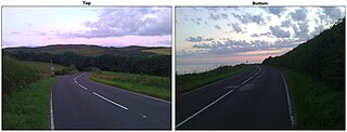
The Electric Brae is a gravity hill in South Ayrshire, Scotland, where a freewheeling vehicle will appear to be drawn uphill by some mysterious attraction. The phenomenon is an optical illusion.

Rajnandgaon is a district of the state of Chhattisgarh in central India. The administrative headquarters the district is Rajnandgaon town.
Polo is a municipality of the Barahona Province in southwestern Dominican Republic, known for its green and high mountains and for growing fine coffee.
Chhuikhadan is a City municipality and district in Khairagarh-Chhuikhadan-Gandai district in the Indian state of Chhattisgarh, India. Chhuikhadan is also known as "city of martyr".

Kawardha is a town and a municipality in Kabirdham district in the Indian state of Chhattisgarh. It is the administrative headquarters of Kabirdham district. Kawardha is also known for the "Temple of Bhoramdeo."
Kabirdham district is one of the 33 administrative districts of Chhattisgarh state in central India. The district was earlier known as Kawardha district. The district is located between 21.32' to 22.28' north latitude and 80.48' to 81.48' east longitude. The district covers an area of 4,447.5 km2 (1,717.2 sq mi). The city of Kawardha is its administrative headquarters. This district is known for the Bhoramdeo temple located at a distance of 18 km from the district headquarters, Kawardha.
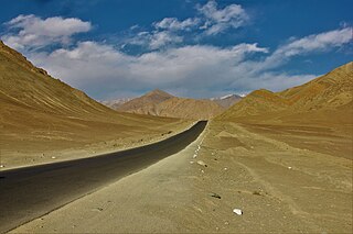
Magnet Hill is a gravity hill located near Leh in Ladakh, India. The layout of the area and surrounding slopes create the optical illusion of a hill. The hill road is actually a downhill road. Objects and cars on the hill road may appear to roll uphill in defiance of gravity when they are, in fact, rolling downhill. It is 7.5 km southeast of Nimmoo and 26.5 km west of Leh on Srinagar-Ladakh road.
Bemetara is a municipality in Bemetara district of Indian state of Chhattisgarh.

Nimo or Nyemo is a village and the headquarters of an eponymous community development block in the Leh district of Ladakh, India. It is located in the Leh tehsil, 35 km from Leh.

Bhoramdeo Temple is a complex of Hindu temples dedicated to the god Shiva in Bhoramdeo, in the Indian state of Chhattisgarh. It comprises a group of four temples of which the earliest is a brick-temple.

Tulsishyam is located on the border of Amareli, Junagadh district and Gir Somnath district, in the Gir National Park in Gujarat state of India. It reachable by road 45 km from Dhari in Amreli district and 35 km from Una in Gir Somnath district.

Kalo Dungar or Black Hill is the highest point in Kutch, Gujarat, India, at 462 m (1,516 ft). It is located 97 km (60 mi) from District headquarters of Bhuj and 25 km (16 mi) from nearest town Khavda.
Mainpat is a hill station and small village in the Surguja district in the northern part of the state of Chhattisgarh, India. It lies about 55 kilometres (34 mi) by road from the divisional headquarter of Ambikapur. The hill station is 50 km south of Ambikapur, 160 km northeast of Korba, and 360 km northeast of state capital Raipur.
Sakri River is a tributary of Shivnath River of Chhattisgarh. The elevation of the river is at 2850 feet and the lowest is at 1200 feet (lowlands). The total length of the river is 90 km, the first village from the origin is Kariyama, district Kabirdham and it merges with the Half river in Darhi village, another tributary of Shivnath river in Bemetara district. Bhoramdeo Temple and Kawardha are the two major sites along the banks of the river.

Khairagarh-Chhuikhadan-GandaiKCG is a district in the central Indian state of Chhattisgarh which consists of three cities, Khairagarh, Chhuikhadan and Gandai. It was carved out of Rajnandgaon in 2022. It is the 31st district of the state inaugurated by chief minister Bhupesh Baghel.

