Delmar is a hamlet in the Town of Bethlehem, in Albany County, New York, United States. It is a suburb of the neighboring city of Albany. The community is bisected by NY Route 443, a major thoroughfare, main street, and route to Albany.

Guilderland is a town in Albany County, New York, United States. In the 2020 census, the town had a population of 36,848. The town is named for the Gelderland province in the Netherlands. The town of Guilderland is on the central-northwest border of the county. It is just west of Albany, the capital of the U.S. state of New York.

Rensselaer is a city in Rensselaer County, New York, United States, and is located on the east side of the Hudson River, directly opposite of Albany. As of the 2020 census, the city population was 9,210. Rensselaer is on the western border of Rensselaer County. The area now known as the City of Rensselaer was settled by the Dutch in the 17th century, who called it t'Greyn Bos, which became Greenbush in English. The city has a rich industrial history stretching back to the 19th century, when it became a major railroad hub; In 2020, Albany-Rensselaer was the ninth busiest Amtrak station in the country and the second busiest in New York State. Rensselaer was one of the earliest locations of the dye industry in the United States, and was the first American location for the production of aspirin.

East Greenbush is a town in Rensselaer County, New York, United States. It is a suburb of Albany. The population was 16,473 at the 2010 census. The word Greenbush is derived from the Dutch het groen bosch, referring to the pine woods that originally covered the land. The first settlement of the land now known as East Greenbush was made by tenants under patroon Kiliaen van Rensselaer circa 1630. The town was established in 1855 as Clinton, and was renamed in 1858. It is mostly suburban along its major highways and rural in the southwestern and northeastern corners.

The Doane Stuart School is a private college preparatory school in Rensselaer, New York. The school is coeducational and interfaith, and it educates students from early childhood through Grade 12.
Glenmont is a hamlet in the town of Bethlehem, Albany County, New York, United States. Glenmont is in the northeastern corner of the town and is a suburb of the neighboring city of Albany. It is bordered to the east by the Hudson River. Originally a farm town, today Glenmont is home to residential neighborhoods, a busy commercial corridor along Route 9W, and industry along the riverfront. It is part of the Bethlehem Central School District.

New York State Route 85 (NY 85) is a state highway in Albany County, New York, in the United States. It is 26.49 miles (42.63 km) in length and runs from CR 353 in Rensselaerville to Interstate 90 (I-90) exit 4 in Albany. It also has a loop route, NY 85A, which connects NY 85 to the village of Voorheesville. The portion of NY 85 north of NY 140 to the Bethlehem–Albany town/city line is known as the Slingerlands Bypass. From there north to I-90, the road is a limited-access, four-lane highway named the Crosstown Arterial.

New York State Route 443 (NY 443) is an east–west state highway in the Capital District of New York in the United States. The route begins at an intersection with NY 30 in the town of Schoharie and ends 33.44 miles (53.82 km) later at a junction with U.S. Route 9W (US 9W) and US 20 in the city of Albany. It ascends the Helderberg Escarpment in the towns of Berne and New Scotland. Within the town of Bethlehem and the city of Albany, NY 443 is known as Delaware Avenue.
Slingerlands is a hamlet in the town of Bethlehem, Albany County, New York, United States. It is located immediately west of Delmar and near the New Scotland town-line and south of the Albany city-limits, and is thus a suburb of Albany. The Slingerlands ZIP Code (12159) includes parts of the towns of New Scotland and Guilderland.
Feura Bush is a hamlet in the town of New Scotland, Albany County, New York, United States. It is in the southeastern corner of the town, along the Bethlehem town-line, eight miles south of Albany. The Feura Bush ZIP Code (12067) includes parts of the town of Bethlehem. It is in the Onesquethaw Volunteer Fire Company fire protection district. The 2020 Census showed 28 employer establishments in the hamlet.
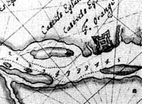
Castle Island is a former island located in the city of Albany, Albany County, New York. Over the past 400 years, Castle Island has been referred to as Martin Gerritse's Island, Patroon's Island, Van Rensselaer Island, and—since the late 19th century--Westerlo Island. The land known as Castle Island has been connected to the mainland and now forms a part of the Port of Albany.
Van Rensselaer Island was an island in the Hudson River opposite the city of Albany, New York. The island was also known as de Laet's Island, Kalebacker's Island, Boston Island and B&A Island, the last two names in reference to the Boston and Albany Railroad. The island stretched from Mill Creek north to the Livingston Avenue Bridge. Van Rensselaer Island is now connected to the City of Rensselaer, and is no longer an island.
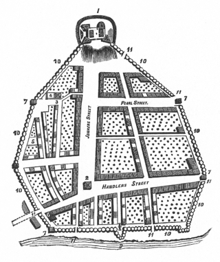
The streets of Albany, New York have had a long history going back almost 400 years. Many of the streets have changed names over the course of time, some have changed names many times. Some streets no longer exist, others have changed course. Some roads existed only on paper. The oldest streets were haphazardly laid out with no overall plan until Simeon De Witt's 1794 street grid plan. The plan had two grids, one west of Eagle Street and the old stockade, and another for the Pastures District south of the old stockade.
Lisha Kill is a hamlet in the town of Colonie, Albany County, New York, United States. Lisha Kill lies on New York Route 5 in the western section of the town. The hamlet received its name from the creek of the same name, Lisha Kill, kill being Dutch for creek or stream. The stream is also referred to as Lisha's Kill and received its name from a local legend about a Native American woman who is buried along its banks.
Guilderland is a hamlet of the town of the same name in Albany County, New York, United States.
Fullers is a hamlet in the town of Guilderland, Albany County, New York, United States. The hamlet lies along U.S. Route 20.
Normansville is a former hamlet in Albany County, New York, United States. In the 19th century, Normansville was a hamlet in the town of Bethlehem. Normansville was located within and along the north and south banks of the ravine carved by the Normans Kill Creek, a tributary of the Hudson River.
South Bethlehem is a hamlet in the town of Bethlehem, Albany County, New York, United States. The hamlet sits on New York State Route 396 and lies southwest of the Selkirk Rail Yard and just north of the Coeymans town line.
Clarksville is a hamlet in the town of New Scotland, Albany County, New York, United States. It is situated along Delaware Turnpike in the southern part of the town at the foot of the Helderberg Escarpment. It is the site of the Clarksville Cave and has an annual Clarksville Heritage Day and Car Show. It is in the Onesquethaw Volunteer Fire Company fire protection district.
Hurstville is a former hamlet in the town of Bethlehem, New York. Today it is part of the city of Albany. Hurstville was located in the area of a bend in the Albany, Rensselaerville, and Schoharie Turnpike at its intersections with Whitehall and Krumkill roads, just outside the city limits of Albany.


