The Mississippi River is the primary river of the largest drainage basin in the United States. From its traditional source of Lake Itasca in northern Minnesota, it flows generally south for 2,340 miles (3,766 km) to the Mississippi River Delta in the Gulf of Mexico. With its many tributaries, the Mississippi's watershed drains all or parts of 32 U.S. states and two Canadian provinces between the Rocky and Appalachian mountains. The river either borders or passes through the states of Minnesota, Wisconsin, Iowa, Illinois, Missouri, Kentucky, Tennessee, Arkansas, Mississippi, and Louisiana. The main stem is entirely within the United States; the total drainage basin is 1,151,000 sq mi (2,980,000 km2), of which only about one percent is in Canada. The Mississippi ranks as the world's tenth-largest river by discharge flow, and the largest in North America.

The Hutt River flows through the southern North Island of New Zealand. It flows south-west from the southern Tararua Range for 56 kilometres (35 mi), forming a number of fertile floodplains, including Kaitoke, central Upper Hutt and Lower Hutt.

U.S. Route 136 is an east-west U.S. highway that is a spur route of U.S. Route 36. It runs from Edison, Nebraska, at U.S. Route 6 and U.S. Route 34 to the Interstate 74/Interstate 465 interchange in Speedway, Indiana. This is a distance of 804 miles (1,294 km). Due to the removal of almost every numbered route in Indianapolis, US 136 never meets its parent, US 36; however, it does come within two miles of it at its interchange with I-465/I-74 at its eastern terminus.

The Washington Avenue Bridge carries County Road 122 and the METRO Green Line light rail across the Mississippi River in Minneapolis and connects the East Bank and West Bank portions of the University of Minnesota campus. The bridge has two decks, with the lower deck designated for motor vehicle traffic and light rail trains and the upper deck used for pedestrians and bicycles. It is a utilitarian structure with simple architecture, but it has cultural significance because thousands of students, faculty, staff, and visitors walk across it every day.

Interstate 270 (I-270) makes up a large portion of the outer belt freeway in Greater St. Louis. The counterclockwise terminus of I-270 is at the junction with I-55 and I-255 in Mehlville, Missouri; the clockwise terminus of the freeway is at the junction with I-55 and I-70 north of Troy, Illinois. The entire stretch of I-270 is 50.59 miles (81.42 km).

The McKinley Bridge is a steel truss bridge across the Mississippi River. It connects northern portions of the city of St. Louis, Missouri with Venice, Illinois. It opened in 1910 and was taken out of service on October 30, 2001. The bridge was reopened for pedestrian and bicyclists on November 17, 2007, with a grand re-opening celebration. Since December 2007, McKinley has been open to vehicular traffic as well. It is accessible from Illinois Route 3 in Illinois and from the intersection of Salisbury and North 9th Street in the city of St. Louis. The bridge carried both railroad and vehicular traffic across the Mississippi River for decades. By 1978, the railroad line over the span was closed, and an additional set of lanes was opened for vehicles in the inner roadway.

The Congressman William L. Clay Sr. Bridge, formerly known as the Bernard F. Dickmann Bridge and popularly as the Poplar Street Bridge or PSB, completed in 1967, is a 647-foot-long (197 m) deck girder bridge across the Mississippi River between St. Louis, Missouri, and East St. Louis, Illinois. The bridge arrives on the Missouri shore line just south of the Gateway Arch.
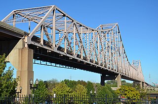
The Martin Luther King Bridge in St. Louis, Missouri, is a cantilever truss bridge of about 4,000 feet (1,200 m) in total length across the Mississippi River, connecting St. Louis with East St. Louis, Illinois. Opened in 1951, the bridge serves as traffic relief connecting the concurrent freeways of Interstate 55, Interstate 64, and U.S. Route 40 with the downtown streets of St. Louis. It was renamed for King in 1968 after the national civil rights leader was assassinated that year.

Interstate 155 (I-155) is a north–south spur of I-55 that provides an Interstate connection for the Illinois cities of Peoria and Lincoln. The northern terminus is just east of Peoria, at I-74 exit 101 in Morton. The southern terminus, which is northwest of Lincoln, is located on I-55 at exit 127. The highway is 32.13 miles (51.71 km) long.

Forgottonia, also spelled Forgotonia, is the name given to a 16-county region in Western Illinois in the late 1960s and early 1970s. This geographic region forms the distinctive western bulge of Illinois that is roughly equivalent to "The Tract", the Illinois portion of the Military Tract of 1812, along and west of the Fourth Principal Meridian. Since this wedge-shaped region lies between the Illinois and Mississippi rivers, it has historically been isolated from the eastern portion of Central Illinois.
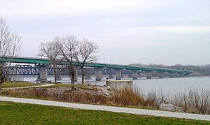
The Great River Bridge is an asymmetrical, single tower cable-stayed bridge over the Mississippi River. It carries U.S. Route 34 from Burlington, Iowa to the town of Gulfport, Illinois.

The Quincy Memorial Bridge is a truss bridge over the Mississippi River in Quincy, Illinois. It brings eastbound U.S. Highway 24 into the city of Quincy from Missouri. It was built in 1930, initially as a toll bridge, and remains structurally sound.

The New Chain of Rocks Bridge is a pair of bridges across the Mississippi River on the north edge of St. Louis, Missouri. It was constructed in 1966 to bypass the Chain of Rocks Bridge immediately to the south. It originally carried traffic for Bypass US 66 and currently carries traffic for Interstate 270. The bridge opened to traffic on September 2, 1966.

The Keokuk Bridge, also known as the Keokuk Municipal Bridge, is a double-deck, single-track railway and highway bridge across the Mississippi River in the United States between Keokuk, Iowa, and Hamilton, Illinois, just downstream of Mississippi Lock and Dam number 19. It was designed by Ralph Modjeski and constructed 1915–1916 on the piers of its predecessor that was constructed in 1869–1871.

Illinois Route 100 (IL-100) is a 159.09-mile-long (256.03 km) state highway in the southwest Illinois. It generally parallels the Illinois River. Starting in downtown Alton, it trends northward to Buckheart Township near Canton. It makes up much of the Illinois River Road, a U.S. National Scenic Byway.

Interstate 74 (I-74) is the central freeway through the Iowa Quad Cities. It roughly divides Davenport to the west and Bettendorf to the east. The Interstate Highway begins at an interchange with I-80 at the northeastern edge of Davenport and continues into Illinois at the Mississippi River by crossing the I-74 Bridge. The freeway was built in stages during the late 1960s and early 1970s.

U.S. Highway 61 (US 61) is a United States Highway that serves eastern Iowa. It enters the state from Missouri near Keokuk with US 136. North of Keokuk, it is overlapped by US 218 for a few miles. It the follows the course of the Mississippi River past Montrose and Fort Madison. It meets US 34 at Burlington. It passes through Wapello and bypasses Muscatine and Blue Grass on its way toward Davenport. There, it follows Interstate 280 (I-280) and I-80 around the Quad Cities. North of Davenport, it follows a freeway north toward DeWitt where it meets US 30. The highway continues north through Maquoketa and reaches the Dubuque area. There it is joined by US 151 and briefly by US 52. The two highways enter the downtown area on an expressway. Due to the proximity of the Mississippi River and railroad tracks that lie between, the routes have an indirect junction with US 20. The two highways leave the state and enter Wisconsin about one-half mile (800 m) north of the Illinois–Wisconsin state line.
U.S. Highway 136 (US 136) is a short U.S. Highway in Keokuk, Iowa. The route was designated nationally in 1951 and has remained largely unchanged through Keokuk since then. The highway originally crossed the Mississippi on the Keokuk Rail Bridge, which was the second bridge built and operated by Andrew Carnegie's Keokuk & Hamilton Bridge Company in that location. While it was designed for wagons and early automobiles, crossing the rail bridge became difficult in larger modern vehicles, specifically semi trucks. As a result, a new automobile-only bridge was built directly to the south of the older span. The Keokuk–Hamilton Bridge opened in 1985 eight months early and under budget.

U.S. Route 67 (US 67) is a component of the United States Numbered Highway System that connects Presidio, Texas, to Sabula, Iowa. In Illinois, it serves the western region of the state known as Forgottonia, named for the lack of regional transportation and infrastructure projects. The highway begins its path through the state by crossing the Clark Bridge over the Mississippi River from Missouri at Alton and heads northward through Jerseyville and Jacksonville before it crosses the Illinois River at Beardstown. The northern half of the route serves Macomb and Monmouth before it enters the Quad Cities. It leaves the state at Rock Island by crossing the Rock Island Centennial Bridge over the Mississippi River into Davenport, Iowa.