Kerrville, Tennessee | |
|---|---|
 Kerrville, Tennessee  Kerrville, Tennessee | |
| Coordinates: 35°22′59″N89°51′29″W / 35.38306°N 89.85806°W | |
| Country | United States |
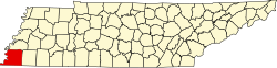
| State | Tennessee |
| County | Shelby |
| Postal code | 38053 |
| Area code | 901 |
Kerrville is an unincorporated community on the northeast portion of Shelby County, Tennessee, United States. Kerrville is located along about 3.5 miles to the north of Millington and just to the south of the Tipton County line, along with Atoka and Munford city limits. It is named for Andrew Hart Kerr, who moved from Middle Tennessee to Big Creek and purchased 5,000 acres of land. [1]