Eads, Tennessee

Last updated

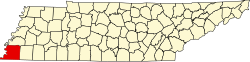
Eads is an unincorporated community in Shelby County, Tennessee, United States, named after Civil War engineer James Buchanan Eads. Some parts of Eads (and some surrounding areas) have been annexed by the city of Memphis. Some of its area is currently still unincorporated. Eads is located north of Collierville, west of Somerville, east of Memphis and Bartlett. The Eads zip code (38028) stretches into both Shelby County and Fayette County, including parts of Hickory Withe and Fisherville. Major roads in the community include Winfield Dunn Parkway (Interstate 269), U.S. Route 64, Collierville-Arlington Road/Airline Road (Tennessee State Route 205), and Seward Road.

Contents

History

The community of Eads was founded in 1888, when the Tennessee Midland Railroad tracks of Tennessee were laid out through a village that was known as Sewardville. [1]

Annexation

After a seven-year court challenge to the right of Memphis to annex, small portions of Eads were annexed into the Memphis City Council Second District in the 1990s.[ citation needed ] Most of Eads is now designated as being in the Memphis reserve, meaning that Memphis can annex it at some point.[ citation needed ]

Deannexation

On January 1, 2020, a portion of Eads on the south side of US 64 and just north of the Grays Creek community, between west of Cobb Road and the unincorporated Shelby County boundary line was deannexed from the City of Memphis to return under county jurisdiction. [2]

Education

Most of Eads is serviced by the Shelby County School System. The private Briarcrest Christian School also has a campus in Eads.

Geography

The center of Eads is located at 35°12'09" North, 89°39'02" West. [3]

Related Research Articles

<span class="mw-page-title-main">Shelby County, Tennessee</span> County in Tennessee, United States

Shelby County is the westernmost county in the U.S. state of Tennessee. As of the 2020 census, the population was 929,744. It is the largest of the state's 95 counties, both in terms of population and geographic area. Its county seat is Memphis, a port on the Mississippi River and the second most populous city in Tennessee. The county was named for Governor Isaac Shelby (1750–1826) of Kentucky. It is one of only two remaining counties in Tennessee with a majority African American population, along with Haywood County.

Hickory Withe is an unincorporated community in Fayette County, Tennessee, United States, and is within the Memphis metropolitan area. For several years it functioned as an incorporated town, and was so treated at the 2000 census, at which time it had a population of 2,574.

<span class="mw-page-title-main">Piperton, Tennessee</span> City in Tennessee, United States

Piperton is a city in Fayette County, Tennessee, United States. The population was 2,263 at the 2020 census. In 2007 USA Today cited the National Motorist Association when it listed Piperton as one of the worst cities for speeding tickets across the USA.

<span class="mw-page-title-main">Collierville, Tennessee</span> Town in Tennessee, United States

Collierville is a town in Shelby County, Tennessee, United States, and a suburb located in the Memphis metropolitan area. With a population of 51,324 in the 2020 census, Collierville is the third largest municipality in the county after Memphis and Bartlett. It is home to the Carriage Crossing shopping mall and is served by Collierville Schools.

<span class="mw-page-title-main">U.S. Route 72</span>

U.S. Route 72 (US 72) is an east–west United States highway that travels for 317.811 miles (511.467 km) from southwestern Tennessee, throughout North Mississippi, North Alabama, and southeastern Tennessee. The highway's western terminus is in Memphis, Tennessee and its eastern terminus is in Chattanooga. It is the only U.S. Highway to begin and end in the same state, yet pass through other states in between. Prior to the U.S. Highway system signage being posted in 1926, the entire route was part of the Lee Highway.

A county island is a small or large portion of an unincorporated area that is within the jurisdiction of a county, usually surrounded by adjacent areas that are incorporated into a municipality. On maps, these geopolitical anomalies will form jagged or complex borders and 'holes' in the city limits. Generally found more frequently in the western United States, county islands form in areas of expansion when previously smaller cities will annex and incorporate more land into their jurisdiction. If residents or landowners in a particular unincorporated area do not vote to incorporate with the surrounding city, the area remains unincorporated. The formation of a county island usually follows stages where it will come into being on the edge of an incorporated area, and as more territory is incorporated, be cut off from the rest of the unincorporated area within the county. These areas are not actually exclaves by definition, because they are simply unincorporated outside of a surrounding city.

<span class="mw-page-title-main">Tennessee State Route 385</span> Highway in Tennessee

State Route 385 (SR 385) is the designation for two non-contiguous segments of east–west controlled-access highway in the Memphis metropolitan area in Shelby County, Tennessee, separated by a section of Interstate 269 (I-269). The northern section, designated as Paul W. Barret Parkway runs between U.S. Route 51 in Millington and I-40 in Arlington, both of which are suburbs of Memphis. The southern segment, known as Bill Morris Parkway, runs between I-240 in southeastern Memphis, and I-269 in Collierville, and also serves the city of Germantown. The northern segment, combined with I-269, serves as a partial outer beltway around Memphis, and the southern segment serves as a spur route between the city and its southeastern suburbs, and is notable for its almost-exclusive use of single-point urban interchanges (SPUIs).

The 8th congressional district of Tennessee is a congressional district in West Tennessee. It has been represented by Republican David Kustoff since January 2017. The district appears rural on a map, but the bulk of its vote is cast in the suburban and exurban areas around Memphis, such as Germantown, Bartlett, and Collierville, as well as Fayette and Tipton counties. This area boasts some of the highest median incomes in the state.

<span class="mw-page-title-main">Geography of Memphis, Tennessee</span>

The City of Memphis is located on the eastern bank of the Mississippi River in the southwest corner of the U.S. state of Tennessee. It is the regional hub for a tri-state area of Arkansas, Mississippi and Tennessee.

<span class="mw-page-title-main">Cordova, Tennessee</span> Community in Tennessee, United States

Cordova is a community in Shelby County, Tennessee, United States. Cordova lies east of Memphis, north of Germantown, south of Bartlett, and northwest of Collierville at an elevation of 361 feet.

Fisherville is an unincorporated community lying between the jurisdiction of Fayette and Shelby County, Tennessee, United States. Fisherville is located between Eads and Collierville, about 30 miles east of downtown Memphis. The zip code for the area is 38028.

<span class="mw-page-title-main">Nonconnah Creek</span> River in Tennessee, United States

The Nonconnah Creek is a 29.7-mile-long (47.8 km) waterway in southwest Tennessee. It starts in extreme southeastern Shelby County, Tennessee, near the town of Collierville. From there, it flows westward, forming the southern border of Germantown. The creek continues to flow west through Memphis and through Whitehaven. Nonconnah Creek empties into McKellar Lake, an oxbow of the Mississippi River. There are three major expressways that follow most of its route. These are Interstate 55, Interstate 240, and Tennessee State Route 385, formerly named and still locally referred to as "Nonconnah Parkway".

<span class="mw-page-title-main">Tennessee State Route 57</span>

State Route 57 is an east–west highway that runs from Memphis to the Mississippi state line near Pickwick Dam and Pickwick Landing State Park. Except for in Shelby County and western Fayette County, SR 57 is a two lane road generally with a 55 mph (89 km/h) speed limit. The majority of the road follows the path of the Memphis and Charleston Railroad.

<span class="mw-page-title-main">Tennessee State Route 175</span>

State Route 175 is a Tennessee designated state route, running for a total of approximately 26.3 miles (42.3 km) through southern Shelby County, Tennessee.

Cayce is an unincorporated community in Marshall County, Mississippi, United States. Although Cayce is an unincorporated community, it has a business district and shares a ZIP code with Byhalia of 38611. The Center of Cayce lies at the junction of Cayce Road and Lee Creek Road, approximately one-half mile south of Mississippi Highway 302.

Westwood is a neighborhood located in southern Memphis, Tennessee, United States, west of Whitehaven. The neighborhood is home to recreational facilities, businesses, schools and churches; including the more than 4,000 member Mt. Vernon Baptist Church. Westwood, Charles Powell Community Center, Westwood Shopping Center, Freedom Preparatory Academy-Westwood Elementary and Westwood High School are focal-points of the community. Double Tree Montessori School is west of Weaver Road and south of Western Park Drive.

<span class="mw-page-title-main">Tennessee State Route 205</span>

State Route 205 is a state highway in Shelby County, Tennessee.

Kerrville is an unincorporated community on the northeast portion of Shelby County, Tennessee, United States. Kerrville is located along about 3.5 miles to the north of Millington and just to the south of the Tipton County line, along with Atoka and Munford city limits. It is named for Andrew Hart Kerr, who moved from Middle Tennessee to Big Creek and purchased 5,000 acres of land.

Southwind High School (SHS) is a public high school located in unincorporated Shelby County, Tennessee, United States, and is operated by the Shelby County Schools district, and is located southeast of Memphis.

References

  1. "Rural Heritage Trust - Eads". ruralheritagetrust.com. Retrieved 2021-07-30.
  2. "Deannexation". City of Memphis. 11 September 2020. Retrieved 2021-06-02.
  3. "US Gazetteer files: 2010, 2000, and 1990". United States Census Bureau. 2011-02-12. Retrieved 2011-04-23.
35°12′8.81″N89°39′1.99″W / 35.2024472°N 89.6505528°W / 35.2024472; -89.6505528