
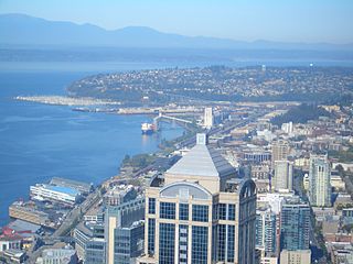
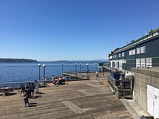
Elliott Bay is a part of the Central Basin region of Puget Sound. It is in the U.S. state of Washington, extending southeastward between West Point in the north and Alki Point in the south. Seattle was founded on this body of water in the 1850s and has since grown to encompass it completely. The waterway it provides to the Pacific Ocean has served as a key element of the city's economy, enabling the Port of Seattle to become one of the busiest ports in the United States.

Downtown is the central business district of Seattle, Washington. It is fairly compact compared with other city centers on the U.S. West Coast due to its geographical situation, being hemmed in on the north and east by hills, on the west by Elliott Bay, and on the south by reclaimed land that was once tidal flats. It is bounded on the north by Denny Way, beyond which are Lower Queen Anne, Seattle Center, and South Lake Union; on the east by Interstate 5, beyond which is Capitol Hill to the northeast and Central District to the east; on the south by S Dearborn Street, beyond which is Sodo; and on the west by Elliott Bay, a part of Puget Sound.
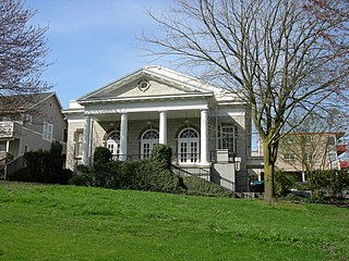
Columbia City is a neighborhood located in the southeastern part of Seattle, Washington in the Rainier Valley district. It has a landmark-protected historic business district and is one of the few Seattle neighborhoods with a long history of ethnic and income diversity.

West Seattle is a conglomeration of neighborhoods in Seattle, Washington, United States. It comprises two of the thirteen districts, Delridge and Southwest, and encompasses all of Seattle west of the Duwamish River. It was incorporated as an independent town in 1902 before being annexed by Seattle five years later. Among the area's attractions are its saltwater beach parks along Elliott Bay and Puget Sound, including Alki Beach Park and Lincoln Park. The area is also known for its views of the Olympic Mountains to the west and the Cascade Range to the east. One-third of Seattle's green space and urban forest is located in West Seattle, much of it in the West Duwamish Greenbelt.
1201 Third Avenue is a 235.31-meter (772.0 ft), 55-story skyscraper in Downtown Seattle, in the U.S. state of Washington. It is the third-tallest building in the city, the eighth-tallest on the West Coast of the United States, and the 97th-tallest in the United States. Developed by Wright Runstad & Company, construction began in 1986 and finished in 1988. 1201 Third Avenue was designed by Kohn Pedersen Fox Associates and The McKinley Architects. The building was the world headquarters of the financial company Washington Mutual from the building's opening until 2006, when the company moved across the street to the WaMu Center.

Queen Anne is a neighborhood and geographic feature in Seattle, Washington, United States, located northwest of downtown. Queen Anne covers an area of 7.3 square kilometers (2.8 sq mi), and has a population of about 28,000. It is bordered by Belltown to the south, Lake Union to the east, the Lake Washington Ship Canal to the north and Interbay to the west.

Beacon Hill is a hill and neighborhood in southeast Seattle, Washington. It is roughly bounded on the west by Interstate 5, on the north by Interstate 90, on the east by Rainier Avenue South, Cheasty Boulevard South, and Martin Luther King Junior Way South, and on the south by the Seattle city boundary. It is part of Seattle's South End.
Magnolia is the second largest neighborhood of Seattle, Washington by area. It occupies a hilly peninsula northwest of downtown. Magnolia has been a part of the city since 1891. A good portion of the peninsula is taken up by Discovery Park, formerly the U.S. Army's Fort Lawton.

Myrtle Edwards Park in Seattle, Washington is a 4.8-acre (1.9 ha) public park along the Elliott Bay waterfront north of Belltown. It features a 1.25-mile (2.01 km) long bicycle and walking path and is a good place to see eagles, gulls, and crows.
Elliott is a small, hilly neighborhood in Pittsburgh, Pennsylvania, United States' West End Region. Elliott is represented on the Pittsburgh City Council by the council member for District 2, and uses the ZIP code 15220.

Rainier Beach is a set of neighborhoods in Seattle, Washington that are mostly residential. Also called Atlantic City, Rainier Beach can include Dunlap, Pritchard Island, and Rainier View neighborhoods.

Kinnear Park is a 14.1-acre (57,000 m2) park on the southwest slope of Queen Anne Hill in Seattle, Washington, United States located between W. Olympic Place on the northeast, W. Mercer Place and Elliott Avenue W. on the southwest, the 9th Avenue W. right of way on the west, and the 6th Avenue W. right of way on the east. It is two-tiered, with a lawn and open space atop the cliff, and a wooded area below.
Waterfront Park is a public park on the Central Waterfront, Downtown, Seattle, Washington, USA. Designed by the Bumgardner Partnership and consultants, it was constructed on the site of the former Schwabacher Wharf.

An outdoor life-size sculpture of Chief Seattle by local artist James Wehn is installed in Tilikum Place in Seattle, Washington, in the United States.

Parsons Gardens Park is a 0.4-acre (0.16 ha) city park in the Queen Anne neighborhood of Seattle, Washington. It was called by Fodor's a "a prim urban oasis", and by another guide a "secret garden for non-tourists". The park sits at one end of West Highland Drive, across the street from Betty Bowen Viewpoint and not far from better-known Kerry Park.

Bayview Park is a 46.63-acre (18.87 ha) park in the Bayview-Hunters Point neighborhood of southeast San Francisco. The park's land is mainly occupied by a large hill named either Bayview Hill or Candlestick Hill, west of the former site of Candlestick Park and east of the Bayshore Freeway; it is prominently visible from both. The hill was initially proposed as parkland by Daniel Burnham in his 1905 Burnham Plan for San Francisco as Visitacion Park, but the park was not created until 1915. Prior to that, the title to the land was held by the Bay View Land Company, which intended to erect luxury houses on the site. After plans for housing fell through, it was proposed to create a pest house on the site in 1902 until the Crocker Land Company donated adjacent land to the city to block plans for the pest house. KYA (1260 AM) opened a studio and 5000-watt radio transmitter on the hill in 1937, and further development of the area occurred in 1958, when part of the hill was quarried to create fill and land for Candlestick Park. Currently, the park receives relatively few visitors to what is considered one of the best-preserved remnants of pre-Columbian open spaces in San Francisco.

1st Avenue is a major street in Seattle, Washington, United States. It traverses Downtown Seattle, including Pioneer Square and Belltown, as well as the adjacent neighborhoods of SoDo and Lower Queen Anne. Numerous landmarks including parks, museums, and historic buildings are located along the street, including Pike Place Market. The Great Seattle Fire of 1889 destroyed much of it and it had to be rebuilt. Parades have taken place on it before and after the fire.

Changing Form is an abstract steel sculpture by artist Doris Totten Chase, installed in the center of Seattle's Kerry Park, in the U.S. state of Washington. The sculpture was given by Mr. and Mrs. Kerry's three children, and stands 4.6 meters (15 ft) tall. Since installation in 1971, the sculpture has been popular among photographers using it to frame the Seattle skyline or Mt Rainier, and children crawling around its smooth, black curves.
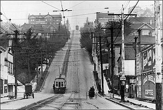
The Queen Anne Counterbalance was a funicular streetcar line operated by the Seattle Electric Company, serving the steep slope along its namesake street on Queen Anne Hill in Seattle, Washington, from 1901 to 1940. It replaced an earlier cable car line built by the Front Street Cable Railway in 1891.

