The fault is more than 100 miles (160 kilometers) long and extends from the tip of the Keweenaw Peninsula in the northeast to a termination near the Michigan-Wisconsin border in the southeast.[4] The fault is most likely younger than the Jacobsville Formation and the Devonian Period.[5]
A seismic event in 1906 claimed to be an earthquake has been attributed to a rock burst, as the area has been significantly mined.[6]
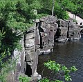
The Natural Wall
Pumpellyite Quartz found in the Keweenaw Fault
One significant feature along the Keweenaw Fault is known as the Natural Wall. The Wall is a near-vertical slope of the Jacobsville Sandstone which dips as steeply 85°.[7] The steep dip of the Jacobsville Sandstone is the result of it being folded due to motion on the fault.
This page is based on this Wikipedia article Text is available under the CC BY-SA 4.0 license; additional terms may apply. Images, videos and audio are available under their respective licenses.