North Parish was created as a civil parish in Prince County, Prince Edward Island, Canada, during the 1764-1766 survey of Samuel Holland.

Pieckowo is a small village in north-east Poland. It is located in Warmian-Masurian Voivodship in Kętrzyn County in Reszel Commune.
There are several lakes named Mud Lake within the U.S. state of Maine.
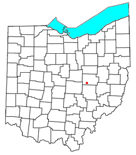
Wakatomika is an unincorporated community in central Washington Township, Coshocton County, Ohio, United States. Wakatomika is located on the Little Wakatomika Creek, and lies along State Route 60.

Rybník is a village and municipality in the Levice District in the Nitra Region of Slovakia.

The Temecula Valley is a graben rift valley in western Riverside County, California.
WEJF is a Christian radio station licensed to Palm Bay, Florida, broadcasting on 90.3 MHz FM. The station serves the Palm Bay-Melbourne area, and is owned by Florida Public Radio, Inc.
Dąbrowa Leśna is a settlement in the administrative district of Gmina Czarna Dąbrówka, within Bytów County, Pomeranian Voivodeship, in northern Poland.

Helenów is a village in the administrative district of Gmina Rawa Mazowiecka, within Rawa County, Łódź Voivodeship, in central Poland. It lies approximately 7 kilometres (4 mi) north-east of Rawa Mazowiecka and 57 km (35 mi) east of the regional capital Łódź.
Cyców-Kolonia Druga is a village in the administrative district of Gmina Cyców, within Łęczna County, Lublin Voivodeship, in eastern Poland.
Izabela is a village in the administrative district of Gmina Wiązowna, within Otwock County, Masovian Voivodeship, in east-central Poland.
Grabowo is a village in the administrative district of Gmina Przasnysz, within Przasnysz County, Masovian Voivodeship, in east-central Poland.
Niekazanice is a village in the administrative district of Gmina Branice, within Głubczyce County, Opole Voivodeship, in southwest Poland, near the Czech border. It lies approximately 5 kilometres (3 mi) east of Branice, 18 km (11 mi) south of Głubczyce, and 69 km (43 mi) south of the regional capital Opole.
Będźmierowice is a village in the administrative district of Gmina Czersk, within Chojnice County, Pomeranian Voivodeship, in northern Poland. It lies approximately 5 kilometres (3 mi) east of Czersk, 35 km (22 mi) east of Chojnice, and 74 km (46 mi) south-west of the regional capital Gdańsk.

The Brucknerhaus is a festival and congress centre in Linz, Austria named after the Austrian composer Anton Bruckner. The building was designed by Finnish architects Heikki and Kaija Siren. Its construction took place from 1969 to 1973. It opened on 23 March 1974.
Veeremäe is a village in Saaremaa Parish, Saare County in western Estonia.

Pusmulići is a village in the municipality of Srebrenica, Bosnia and Herzegovina.

The Dragon and Tiger Pagodas is a temple located at Lotus Lake in Zuoying District, Kaohsiung, Taiwan. The temple was built in 1976. One of the towers is the Tiger Tower, the other one being the Dragon tower.
St. Vincent College (CDP) is a census-designated place located in Unity Township, Westmoreland County in the state of Pennsylvania. The community is centered on Saint Vincent College located to the south of Latrobe near U.S. Route 30. As of the 2010 census the population was 1,357 residents.
Bain Hill is a summit in St. Francois County, Missouri. It has a peak elevation of 1,106 feet (337 m). The hill rises to the east of and about 200 feet above the Little St. Francis River. Knob Lick lies about four miles to the west and Mine La Motte is about five miles to the south in Madison County.