
The Godavari is India's second longest river after the Ganga river and drains into the third largest basin in India, covering about 10% of India's total geographical area. Its source is in Trimbakeshwar, Nashik, Maharashtra. It flows east for 1,465 kilometres (910 mi), draining the states of Maharashtra (48.6%), Telangana (18.8%), Andhra Pradesh (4.5%), Chhattisgarh (10.9%) and Odisha (5.7%). The river ultimately empties into the Bay of Bengal through an extensive network of distributaries. Measuring up to 312,812 km2 (120,777 sq mi), it forms one of the largest river basins in the Indian subcontinent, with only the Ganga and Indus rivers having a larger drainage basin. In terms of length, catchment area and discharge, the Godavari is the largest in peninsular India, and had been dubbed as the Dakshina Ganga.
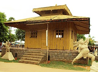
Parnasala is a village in the Dummugudem mandal in the newly formed Bhadradri Kothagudem district of Telangana, India. The village is accessible by road and boats and is situated 32 km from the temple town of Bhadrachalam.

Bhadrachalam is a census town in Bhadradri Kothagudem district in the Indian state of Telangana. It is an important Hindu pilgrimage town with the Bhadrachalam Temple of Lord Rama, situated on the banks of Godavari river. It is located 312 kilometres (194 mi) east of state capital, Hyderabad,115 kilometres (71 mi) from Khammam,178 kilometres (111 mi) from Suryapet,180 kilometres (112 mi) from Warangal,187 kilometres (116 mi) from Vijayawada,220 kilometres (137 mi) and 350 kilometres (217 mi) from Visakhapatnam.

Kovvur is a town in East Godavari district of the Indian state of Andhra Pradesh. It is a municipality and the mandal headquarters of Kovvur mandal in Kovvur revenue division.

Khammam district is a district in the eastern region of the Indian state of Telangana. The city of Khammam is the district headquarters. The district shares boundaries with Suryapet, Mahabubabad, Bhadradri districts and with Eluru and NTR districts.

Nizamabad district is a district located in the north-western region of the Indian state of Telangana. The city of Nizamabad is the district headquarters. The district share boundaries with Jagtial, Sircilla, Nirmal, Kamareddy districts and with Nanded district of the state boundary of Maharashtra.
Luxettipet or Lakshettipet is a municipality and census town in Mancherial district of the Indian state of Telangana. Located on the north bank of godavari river. And it is municipality and the headquarters of Luxettipet mandal. It is located in Luxettipet mandal of Mancherial revenue division.

Bhainsa is a town in Nirmal district of the Indian state of Telangana. It is the headquarters of Bhainsa mandal and Bhainsa revenue division. It is bordered with Bhokar taluk, Nanded district, Maharashtra State on west and Nizamabad district on South. Bhainsa is located at 19.1000°N 77.9667°E. It has an average elevation of 363 meters (1194 feet).
Nirmal is a city and the district headquarters of Nirmal district in the Indian state of Telangana. It is famed for its toys made out of wood.
Sathupalli is a town in Khammam district of the Indian state of Telangana. It is a Municipality in Sathupalli mandal of Kalluru revenue division. It is situated approximately 276 km (171 mi) east of Hyderabad, 80 km (50 mi) from Khammam and 200 km (120 mi) from Warangal. It is about 135 km (84 mi) north of Amaravati, the state capital of Andhra Pradesh, and 126 km (78 mi) west of Rajahmundry.
Ichoda is a town in Adilabad district in the state of Telangana in India.
Kaddam is a village in Nirmal district in the state of Telangana in south India.
Laxmanchanda is a Mandal in Adilabad district in the state of Telangana in India. It is one of the 5 mandals in Nirmal assembly segment. Laxmanchanda mandal is agriculturally well developed due to good irrigation facilities as its presence nearer to river Godavari and Sriramsagar dam. Establishing own intermediate and degree colleges by co-operative and village development societies has made the village to emerge in education field. Mandal headquarters is about 15 km from Nirmal town.
Samsthan Narayanapur is a Mandal in Bhuvanagiri district of Telangana State, India. Narayanapur Mandal Headquarters is Narayanapur town. It belongs to Telangana region. It is located 39 km towards west from District headquarters Bhongir.

Khanapur is a constituency of Telangana Legislative Assembly, India. It is one of 3 constituencies in Nirmal district. It comes under Adilabad Lok Sabha constituency along with 6 other Assembly constituencies.

Adilabad district is a district located in the northern region of Telangana, India. It is known as the gateway district to South and Central India. The town of Adilabad is its headquarters. The district shares boundaries with Asifabad, Nirmal districts and with the state boundary of Maharashtra.
Chennur is a census town in Mancherial district of the Indian state of Telangana. located on the banks of Godavari river. Generally Godavari flows from west to east but the Godavari river in Chennur flows towards the north for 5 Kosa (15 km) hence it is known as "Panchkosha Uttara Wahini". and It is a Municipal Council and the headquarters of Chennur mandal, It is located in Chennur mandal of Mancherial revenue division and Chennur is assembly constituency.
Mancherial district is a district located in the northern region of the Indian state of Telangana. The district comprises 18 mandals and two revenue divisions – Mancherial and Bellampalli. The district headquarters is located at Mancherial town. It is surrounded by Komaram Bheem, Nirmal, Jagtial, Peddapalli and Bhupalpally districts of Telangana and with Maharashtra state.

Nirmal district is a district located in the northern region of the Indian state of Telangana. The district headquarters is located in the town of Nirmal. It borders the Telangana districts of Adilabad, Nizamabad, Mancherial, Asifabad, Jagtial districts as well as Nanded district of the state Maharashtra.
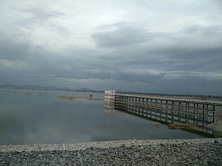
Sadarmat Barrage is an under-construction barrage across Godavari River at Ponkal village, Mamda mandal, Nirmal district of Telangana State. This barrage is situated 32 km downstream of Sriram Sagar Project, on the Godavari river and about 7 km upstream of Sadarmat Anicut. The project will provide irrigation facilities for an ayacut of 20,000 acres in Nirmal district of Telangana State.


