Kharnal

Last updated

Kharnal
Village
Tejaji Temple Kharnal.JPG
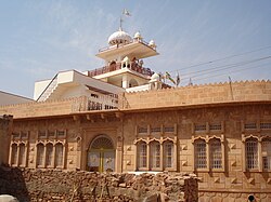
Tejaji Temple at Kharnal
India Rajasthan location map.svg
Red pog.svg
Kharnal
Location in Rajasthan, India
India location map.svg
Red pog.svg
Kharnal
Kharnal (India)
Coordinates: 27°05′09″N73°38′41″E / 27.08576°N 73.644705°E / 27.08576; 73.644705
CountryFlag of India.svg  India
State Rajasthan
District Nagaur
Area
  Total2,650.68 ha (6,549.97 acres)
Population
 (2011)
  Total2,812
  Density110/km2 (270/sq mi)
Languages
  Official Rajasthani
Hindi
Time zone UTC+5:30 (IST)
ISO 3166 code RJ-IN
Vehicle registration RJ-21

Kharnal is a village in Nagaur district of Rajasthan, India. It is birthplace of popular folk deity Veer Tejaji. He was born in the family of Tahar Dev and Ramkunwari Devi, who were Dhauliya Jats. [1] [2]

Contents

Demography

It is the main village of Dhaulya Jats. There are four branches of Dhaulyas descendants of Hema, Dulha, Dhanna and Pipa. Other Jat gotras in the village are Dahiya, Mahiya, Jakhar, Karvir and Benda.

Other castes dwelling in the village are Muslims, Teli, Nayak, Balai, Luhar, Sunar, Brahman and Baniya. There is no Rajput. Kharnal has a total population of 2,812 peoples according to Census 2011. [3]

There is a big temple of Tejaji in Kharnal facing north direction. In the temple there is a brass statue of Tejaji with mukut and kalgi and a bhala in hand. Outside the village there is a small temple of Tejaji at a distance of 1.5km from big temple. People of this village tell that the statue of Tejaji had come out of soil naturally. This statue is believed to be about 1000 years old. This temple is located in Dhawa johar, the water of which is used for drinking by the villagers.

− Temple of Rajal, sister of Tejaji, who became sati with Tejaji, is situated at a distance of 1 km from village in the east direction.

Kharnal is also a village in Doda district in Jammu and Kashmir.

See also

Related Research Articles

<span class="mw-page-title-main">Rajasthan</span> State in northwestern India

Rajasthan is a state in northwestern India. It covers 342,239 square kilometres (132,139 sq mi) or 10.4 per cent of India's total geographical area. It is the largest Indian state by area and the seventh largest by population. It is on India's northwestern side, where it comprises most of the wide and inhospitable Thar Desert and shares a border with the Pakistani provinces of Punjab to the northwest and Sindh to the west, along the Sutlej-Indus River valley. It is bordered by five other Indian states: Punjab to the north; Haryana and Uttar Pradesh to the northeast; Madhya Pradesh to the southeast; and Gujarat to the southwest. Its geographical location is 23°.3' to 30°.12' North latitude and 69°.30' to 78°.17' East longitude, with the Tropic of Cancer passing through its southernmost tip.

<span class="mw-page-title-main">Narsinghpur</span> City in Madhya Pradesh, India

Narsinghpur is a city in Madhya Pradesh in central India. It is a district under Jabalpur division. Narsinghpur has a large temple dedicated to Lord Narasimha. As of 2001, Narsinghpur is the most literate district of the state.

Kheda is a city and a municipality in the Indian state of Gujarat. It was former administrative capital of Kheda district. India's First Deputy Prime Minister Vallabhbhai Patel Was Born In Kheda District of Gujarat State. Kheda city is famous for tobacco farming. The nearest railway station is Mahemadavad Kheda Road. The nearest airport is Ahmedabad airport. The nearest bus station is Kheda Bus Station.

<span class="mw-page-title-main">Chamoli district</span> District of Uttarakhand in India

Chamoli district is a district of the Uttarakhand state of India. It is bounded by the Tibet region to the north, and by the Uttarakhand districts of Pithoragarh and Bageshwar to the east, Almora to the south, Pauri Garhwal to the southwest, Rudraprayag to the west, and Uttarkashi to the northwest. The administrative headquarters of Chamoli district is in Gopeshwar.

<span class="mw-page-title-main">Veer Teja</span> Indian folk deity

Veer Tejaji also known as Tejaji Maharaj, or simply Tejaji, was a great warrior, social reformer and folk-deity of Rajasthan. In rural parts of northern Rajasthan, he is revered as a deity and is considered to be one of Lord Shiva's eleven primary incarnations. He is mainly worshipped in the states of Rajasthan, Madhya Pradesh, Haryana, Uttar Pradesh, and Gujarat. He is commonly known as the God of Snakes in Rajasthan, because it protect against snake bites or also worshipped as Dhauliya Veer.

<span class="mw-page-title-main">Nagaur</span> City in Rajasthan, India

Nagaur is a city and municipal council in Nagaur district of the state of Rajasthan in India. It is the administrative headquarters of Nagaur District. The Nagaur city lies about midway between Jodhpur and Bikaner.

<span class="mw-page-title-main">Tikamgarh</span> City in Madhya Pradesh, India

Tikamgarh is a town and a tehsil in Tikamgarh district in the Indian state of Madhya Pradesh. The city serves as a district headquarters. The earlier name of Tikamgarh was Tehri consisting of three hamlets, forming a rough triangle. In Tikamgarh town there is locality still known as 'Purani Tehri'. Until Indian independence in 1947, Tikamgarh, formerly called Tehri, was part of the kingdom of Orchha, which was founded in the 16th century by the Bundeli chief Rudra Pratap Singh, who became the first King of Orchha. In 1783 the capital of the state was moved to Tehri, about 40 miles (64 km) south of Orchha, which was home to the fort of Tikamgarh, and the town eventually took the name of the fort. The district is famous for the old fort of Kundar known as Garh Kundar, which was built by Khangars and remained the capital of Khangar rulers from 1180 to 1347.

<span class="mw-page-title-main">Jeenmata</span> Village in Rajasthan, India

Jeenmata is a village in Sikar district of Rajasthan, India. It is located at a distance of 29 km from Sikar town in south. There is an ancient Temple dedicated to Shree Jeen Mataji. Millions of devotees come here during Navaratri. There are a number of dharamshalas to accommodate large number of visitors.

<span class="mw-page-title-main">Pauri Garhwal district</span> District in Uttarakhand, India

Pauri Garhwal is a district in the Indian state of Uttarakhand. Its headquarters is in the town of Pauri. It is sometimes referred to simply as Garhwal district, though it should not be confused with the larger Garhwal region of which it is only a part of.

<span class="mw-page-title-main">Nagaur district</span> District in Rajasthan, India

Nagaur District is one of the 50 districts of the state of Rajasthan in western India. Panchayati Raj was introduced here. It is the fifth largest district in Rajasthan and the area of the district is 17,718 km2 (6,841 sq mi). The city of Nagaur is the district headquarters.

Ramdurg is a town in Belagavi district in the Indian state of Karnataka. The name of the town derives from Rama, as it is believed that Lord Ram, lived here during his exile. The town gives its name to Ramdurg taluka, a subdivision of Belagavi district.

<span class="mw-page-title-main">Newai</span> Town in Rajasthan, India

Newai or Niwai is a town, and a municipality and tehsil in Tonk district in the Indian state of Rajasthan. The Tonk district is bounded in the north by Jaipur district, in the east by Sawai Madhopur district, in the southeast by Kota district, in the south by Bundi district, in the southwest by Bhilwara district, and in the west by Ajmer district. Jaipur, capital of Rajasthan is the closest major city to Newai. In 1783 Nepalia-Mathur Kayastha of Jaipur estate occupied it after defeating Nawab of Tonk in a bloody battle fought at the fort of Rakhtanchal. Since then it was a vassal state to the Jaipur estate until Jaipur became part of Independent India. Darbar of Daroga ji ruled Niwai under Maharaja of Jaipur.

<span class="mw-page-title-main">Sursura</span> Village in Rajasthan, India

Sursara, also known as Sursura is a village in Kishangarh tehsil in Ajmer district in the Indian state of Rajasthan, situated 8 km south of Rupangarh town on Parbatsar - Kishangarh road. This is the place where the Jat folk-deity Tejaji died from a snakebite when he back on the way after fighting with the enemies on 28 August 1103.

Kudra, formerly known as Jahanabad, is a town and corresponding community development block in Kaimur district in the state of Bihar, India. It is the third largest town in Kaimur district. It is situated about 18 km from District Headquarter Bhabua. As of 2011, the population of Kudra was 30986. The railway station in Kudra is connected to all major railway routes.

Hindoli is a small town in the Bundi district of Rajasthan, India. Situated in the lap of the Arawalli Hills, the town is a trade center for many small villages.

Jhanwar is a village and a newly made tehsil in the Jodhpur district of Rajasthan, India.This village was settled by Chaudhary Malji Kalirana around 1200 AD.

<span class="mw-page-title-main">Sunari</span> Village in Rajasthan, India

Sunari is a village in Ladnun tehsil, Nagaur district, Rajasthan, north west India. Its lok sabha is Churu constituency. The residents, numbering between five and six thousand, are Hindu. Sunari lies on the edge of the Thar desert.

Meethari Marwar is a village in Ladnun tehsil of Didwana-Kuchaman district in the Indian state of Rajasthan.

<span class="mw-page-title-main">Jhunjhala</span> Village in Rajasthan, India

Junjala or Jhunjhala is a small village in Nagaur district, Rajasthan, India. Jhunjhala has a total population of 740 peoples according to Census 2011.

Onkar Singh Lakhawat is an Indian lawyer, politician, writer, and a senior BJP leader from Rajasthan. He is serving as the Chairman of Rajasthan Heritage Conservation and Promotion Authority. He is a former Member of Parliament in the Rajya Sabha (1997–2000). He was a Minister of State in the Second Raje ministry (2014-2019). He was also the Vice-President of the BJP in Rajasthan.

References

  1. mediology (10 June 2022). "राजस्थान में नागौर के खरनाल गांव में बनेगा वीर तेजाजी का मंदिर". dainiktribuneonline.com. Retrieved 21 August 2024.
  2. Gupta, Dr Seema (30 October 2020). "Veer Tejaji - The Symbol of Folk Faith". Central Asian Journal of Literature, Philosophy and Culture. 1 (1): 40–46. ISSN   2660-6828.
  3. "Basic Population Figures of India, States, Districts, Sub-District and Village, 2011".