
The North Western Railway is one of 19 railway zones in India. It is headquartered at Jaipur, Rajasthan and has 59,075+ employees, 658+ stations and a route length of more than 5,761 kilometres (3,580 mi) across the states of Rajasthan, Gujarat, Punjab and Haryana. NWR operates international rail service Thar Express from Jodhpur to Karachi. This zone is the key enabler of the Delhi–Mumbai Industrial Corridor Project by virtue of running railways 1,500 km long Western Dedicated Freight Corridor.

Nagaur is a city and municipal council in Nagaur district of the state of Rajasthan in India. It is the administrative headquarters of Nagaur District. The Nagaur city lies about midway between Jodhpur and Bikaner.

Didwana serves as the temporary district headquarters for Didwana-Kuchaman district of Rajasthan, India. Known as the lion gateway of Marwar and the archway of Merta, it is mentioned in puranic texts as Abhanagri and Upakashi, and is situated on the northern side of Didwana Salt lake. It was administered as a tehsil of Nagaur district before being notified as a district. The people of Didwana speak the Rajasthani language Marwadi, a dialect in the Indo-Aryan language family, which is similar to Hindi.

Nagaur District is one of the 50 districts of the state of Rajasthan in western India. Panchayati Raj was introduced here. It is the fifth largest district in Rajasthan and the area of the district is 17,718 km2 (6,841 sq mi). The city of Nagaur is the district headquarters.

Bachhraon is a city and a municipal board in Amroha district in the state of Uttar Pradesh, India.
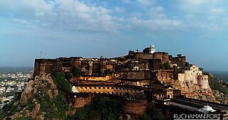
Kuchaman CityHindi pronunciation:[/ˌkuːtʃəˈmɑːnˈsɪti/] is a Municipal Council and District Headquarters of Didwana-Kuchaman District located in west-central Rajasthan, India. It is the largest city of newly Kuchaman district. The Didwana-Kuchaman district was carved out from the Nagaur District as the 38th District of the state of Rajasthan on 4 August 2023.

Ladnu, also Ladnun, is a city and a municipality, nearby Nagaur city in Didwana Kuchaman District in the Indian state of Rajasthan. It is a Tehsil headquarters of Didwana Kuchaman District. This city is famous as the birthplace of sacred Jain Aacharya Tulsi. It is the city of Jain temples and one of the most visited pilgrim places of Jain community after Shri Mahaveer ji. Ladnun is also home to the Jain Vishva Bharati University, several Jain temples with extensive marble work, Ramanand gaushala and other old temples of religious and architectural importance. Places within 15–20 km of Ladnun include Tal chhapar, Dungar Balaji, Salasar Balaji Dham, Tirupati Balaji at Sujangarh,Bhairav Baba Mandir at Bader village. Ladnun is also famous for cotton sarees.

Merta City is a city and a municipality located, near Nagaur City in Nagaur district in the Indian state of Rajasthan. Merta is also known for its link with Mira Bai, the devotee of Lord Krishna. Mira Mahal Museum houses memories related to Mira Bai's lifetime
Mundwa also known as Marwar Mundwa, is a city and a municipality in Nagaur district in the Indian state of Rajasthan. Mundwa is a tehsil in Nagaur district of Rajasthan State, India. It is located 20 km towards South from district headquarters Nagaur. 231 km from state capital Jaipur towards East. Marwari is the Local Language here. Also People Speaks Hindi, English, Urdu and Rajasthani. Mundwa was also a constituency of Rajasthan Assembly before it was changed to Khinvsar because of political reasons. Now Mundwa is made a Tehsil. It is also allotted a Dhan Mandi. It is a pilgrimage centre for the shrine of the Sufi Haz Jana Sahid and is also famous for the lot of temples.
Degana is a town municipality and headquarter to Sub-Division and Tehsil located in Nagaur district of Rajasthan, India.
Bijainagar is a city and headquarters of Bijainagar tehsil in the Beawar district of the Indian state of Rajasthan.It was founded by Shri Rao Saheb Vijay Singh ji Of Masuda in 1919 CE,This city is situated along the Khari River close to the southern border of Ajmer District.

Rajasthan is one of the most popular tourist destinations in India, for both domestic and international tourists. Rajasthan attracts tourists for its historical forts, palaces, art and culture with its slogan "Padharo Mhare Desh " The capital city, Jaipur, also known as Pink City, is a very popular tourist destination and is a part of the Golden Triangle. The Walled City of Jaipur is only the second Indian city to be recognized as a UNESCO World Heritage Site, after Ahmedabad.
Jiliya is a place in Nagaur District of Rajasthan, India. It was a Princely Thikana in British India. It is developing as a tourist spot to explore the natural environment of Rajasthan. The majority of the population is involved in agricultural and trade activities. NGOs such as Sankalp Volunteer Society are active in this region of Rajasthan and foreigners participate in the "Jiliya Project" which is one of the five projects of this NGO in India.
The term Rajasthani Muslims is usually used to signify Muslims from the state of Rajasthan in the north-western part of India and speak Hindi, Urdu and Sindhi languages.
Minda is a village located in the Nawa tehsil under Nagaur district, in the state of Rajasthan, India. It is one of 217 villages in nawa Block along with villages like Takiya, Thikariya and Naya Bas, Bawari dariya ka bas. Nearby railway station is Minda railway station which is in between Renwal and Bhainslana stations. This railway track starts from Delhi, Gurgaon, Rewari, Narnaul, Ringus, Renwal, Minda, Phulera and up to Ajmer. However, Jaipur Railway Station is major railway station 58 km near to Minda via Phulera.
Nimbi Jodha is a town in Ladnu, Nagaur District, Rajasthan, India. It belongs to Ajmer Division. It is located 75 km east of the district headquarters, Nagaur, and 51 km from Salasar Balaji.

Junjala or Jhunjhala is a small village in Nagaur district, Rajasthan, India. Jhunjhala has a total population of 740 peoples according to Census 2011.
Devli Kalan is a village in Nawa Tehsil in Didwana Kuchaman district of Rajasthan State, India. It belongs to Ajmer Division. It is located 176 km towards East from District headquarters Nagaur, 60 km from State capital Jaipur. Devli Kalan Pin code is 341507 and postal head office is Maroth. Renwal, Jaipur, Sambhar, Phulera, Reengus are the nearby Cities to Devli Kalan. Minda, Loonwa, Shyamgarh & KANCHANPURA 1.5 km are the nearby Villages to Devli Kalan. As per constitution of India and Panchyati Raaj Act, Devli Kalan village is administrated by Sarpanch who is elected representative of village.
Sudrasan village is located in Didwana Tehsil of Nagaur district in Rajasthan, India. It is situated 32 km (20 mi) from sub-district headquarters Didwana and 132 km (82 mi) from district headquarters Nagaur. As per 2009 stats, Sudrasan village is also a gram panchayat.

Kuchaman City Railway station is a railway station established in Narayanpura village which is 9 km away from kuchaman city in Didwana-Kuchaman district, Rajasthan. Its code is KMNC. It provides railway services to Kuchaman City and all near small villages. The station consists of a single platform. Passenger, Express, and Superfast trains halt here.

