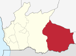
Ukerewe District is one of the seven districts of the Mwanza Region of Tanzania. It is located on Ukerewe Island, Ukara Island and other neighbouring islands within Lake Victoria. The largest settlement and the district's administrative capital is Nansio.
Varzob is a settlement in Varzob District, Districts of Republican Subordination, Tajikistan, in central Asia. It is the administrative center for the Varzob District.

Bariadi District is one of the five districts of the Simiyu Region of Tanzania, East Africa. As of 2022, the population was 383,385.

Tunduru District is one of the five districts in the Ruvuma Region of Tanzania. It is bordered to the north by the Lindi Region, to the east by the Mtwara Region, to the south by Mozambique and to the west by the Namtumbo District. The district is the birthplace of famous artist Edward Tingatinga.
Al Abraq is a town in Libya, in the Derna District. It is located 23 km east of Bayda, Other names include the transliterations Al Labrag, Al Labraq, Al Lazraq, and El-Abràgh, as well as the Italian Luigi di Savoia. According to the census of 2006, the city had a population of 8861 people.
Lal (La'l) sometimes called Lal wa Sarjangal is a town and the administrative center of Lal wa Sarjangal District, Ghor province in central Afghanistan.

Mbamba Bay is a town in western Tanzania, lying on the eastern shore of Lake Malawi/Lake Nyasa.
Mutukula, sometimes spelled as Mtukula, is a small town in Missenyi District, Kagera Region, in northwestern Tanzania, at the border with Uganda. Formerly, the settlement on the border was known as Kyebisagazi, and Mutukula was a kilometre to the south on the east side of the Masaka-Bukoba Road (B8).
Mdandu is a town and ward in Wanging'ombe District of Njombe Region in the southern highlands of Tanzania, East Africa. As of 2002, the population of the ward was 26,149.
Wanging'ombe is a town and ward in Wanging'ombe District in the Njombe Region of the Tanzanian Southern Highlands. As of 2002, the population of the ward was 18,545.
Chato is a town in Geita Region of northwestern Tanzania, and a port on the southern end of Lake Victoria. It is the administrative centre for Chato District.
The Simiyu River is a river located in Simiyu Region and Arusha Region, Tanzania. It flows into Lake Victoria in the African Great Lakes region. As one of the six main inlets to Lake Victoria, it forms part of the upper headwaters of the Nile. The Simiyu Region is named after the river.
Ugalla is a small town and ward in Mlele District of Katavi Region, Tanzania, East Africa. The town is on the left (west) bank of the Mtambo River just before it flows into the Ugalla River, on the edge of the Lujaba Swamp.
Tunduru is a town in Tunduru District, Ruvuma Region, Tanzania, East Africa. It is the administrative seat for Tunduru District, and is administratively divided into two wards; Mlingoti West and Mlingoti East.

Babati is a town in Babati Urban District of Manyara Region of Tanzania. It is the administrative capital of Babati Urban District and Babati Rural District and also the administrative capital of Manyara Region.
Kilosa (Kilossa) is a town in the Morogoro Region of Tanzania, East Africa. It is the administrative seat for Kilosa District. As of 2022, the population of the town was 43,418.
Boma ya Ulanga (Ulanga) is a village in Ulanga District, Morogoro Region of central Tanzania. It is on the west bank of the Ulanga River.

Ulanga District is one of the six districts of the Morogoro Region of Tanzania. the administrative seat is in Mahenge. It covers 24,460 square kilometres (9,444 sq mi) of which 4,927 square kilometres (1,902 sq mi) is in forest reserves. Ulanga District is bordered to the north and west by the Kilombero District, to the east by the Lindi Region and to the south by the Ruvuma Region.
Rubeho is a town and ward in Gairo District in the Morogoro Region of Tanzania, East Africa. As of 2002, the population of the ward was 17,020. Prior to 2012, Rubeho was administered by Kilosa District.
Paung-deh or Paungde is a town in Pyay District, Pegu region in Burma (Myanmar). It is the administrative seat of Paungde Township.


