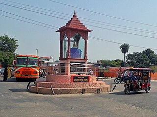
Budaun is a medieval city and headquarters of Budaun district, Uttar Pradesh, India. It is located about a mile east of the Sot river, and 27 km north of the river Ganges, in the Rohilkhand region of Uttar Pradesh. According to the 2011 census, it has a total population of 159,221, which is projected at 161,555 at present. Budaun rose to historical importance as the capital of the Delhi Sultanate for four years from 1210 CE to 1214 CE during the reign of Sultan Iltutmish. It was the most important post of Northern Frontier during Mughal reign. Budaun is a big market, historically famous and religiously important city. Budaun is 230 km south-east of New Delhi and 245 km north-west of Lucknow, both taking about 6 hours by road.
Aminagar Sarai is a town and a nagar panchayat in Baghpat district in the state of Uttar Pradesh, India. It is the oldest town in the Meerut commissionary area.
Bhadarsa is a town and nagar panchayat in Ayodhya district in state of Uttar Pradesh, India. Bhadarsa is 22 km south of district headquarters Ayodhya city.
Danapur Cantonment or Danapur Cantt is a cantonment town in Danapur, Patna District in the state of Bihar, India. Danapur is a category II cantonment, established in 1765. The board consists of 14 members including 7 elected members. Danapur Cantonment, located on the outskirts of Patna, is the second oldest cantonment in India, after Barrackpur Cantonment, West Bengal. Danapur is the regimental centre of the Bihar Regiment (BRC). It was earlier called Bankipore Cantonment. Initially, it was set up at Bankipore but later set up in the Danapur area in 1766–67.
{{Infobox settlement | name = Karhal | official_name = | other_name = | nickname = | settlement_type = Town | translit_lang1 = | image_skyline = | image_alt = | image_caption = Karhal | flag_size = 3:2 | pushpin_map = India Uttar Pradesh | pushpin_label_position = right | pushpin_map_alt = | pushpin_map_caption = Location in Uttar Pradesh, India | coordinates = 26.9975978°N 78.9415151°E | subdivision_type = Country | subdivision_name = India | subdivision_type1 = State | subdivision_name1 = Uttar Pradesh | subdivision_type2 = District | subdivision_name2 = Mainpuri | subdivision_type3 = Tehsil | subdivision_name3 = Karhal | established_title = | established_date = | founder = | named_for = | government_type = Vidhan Sabha | governing_body = Uttar Pradesh | unit_pref = Metric | area_footnotes = | area_rank = 112 | area_total_km2 = 9.58 | elevation_footnotes = | elevation_m = 159 | population_total = 27,701 | population_as_of = 2011 | population_rank = | population_density_km2 = auto | population_demonym = | population_footnotes = | demographics_type1 = Languages | demographics1_title1 = Official | demographics1_info1 = Hindi | blank1_name_sec1 = SDM | blank1_info_sec1 = R.N. Verma | blank2_name_sec1 = MP | blank2_info_sec1 = Dimple Yadav | blank3_name_sec1 = MLA | blank3_info_sec1 = Akhilesh Yadav l blank3_info-sec1 = Chaudhry Abdul Naeem ([[ Karhal [Chairman] | blank5_name_sec1 = Highways | blank5_info_sec1 = Agra-Lucknow Expressway, State Highway 83 | timezone1 = IST | utc_offset1 = +5:30 | postal_code_type = PIN | postal_code = 205264 | area_code_type = Telephone code | area_code = 05677 | registration_plate = UP-84 | footnotes = }}
Rudauli is a town, tehsil and a municipal board in Ayodhya district in the Indian state of Uttar Pradesh. Rudauli is 50 km west of the district headquarters Ayodhya.
Loni is a town, near Ghaziabad city in Ghaziabad district in the state of Uttar Pradesh, India and Loni town is governed by Loni Municipal Council which comes under Ghaziabad Metropolitan Region.
Rali Chauhan is a village in the Meerut district of Uttar Pradesh state, India, and forms a part of the National Capital Region (NCR). It is located 9 km (5.6 mi) from the district capital of Meerut, and 457 km (284 mi) from Lucknow, the state capital. Rali Chauhan's Pincode is 250002. Nearby villages include Islamabad Chhilora, Bhawanpur, Datavali Gesupur, and Ajanta Colony.
Rajesultanpur or Raje Sultanpur is a town and nagar panchayat in Ambedkar Nagar district in the Indian state of Uttar Pradesh.
Sir Gobardhan is a census town in Varanasi tehsil of Varanasi district in the Indian state of Uttar Pradesh. The census town & village falls under the Shir Goverdhanpur gram panchayat. Sir Gobardhan Census town & village is about 13 kilometers South of Varanasi railway station, 323 kilometers South-East of Lucknow and 3.5 kilometers South-East of Banaras Hindu University main gate. It is of historical significance as it is birthplace of Sant Sri Guru Ravidas. Shri Guru Ravidass Janam Asthan at Seer Goverdhanpur is main pilgrimage place for Ravidasis worldwide.
Salarpur is a census town in Varanasi tehsil of Varanasi district in the Indian state of Uttar Pradesh. The census town & village falls under the Salarpur gram panchayat. Salarpur Census town & village is about 8 kilometres North-East of Varanasi railway station, 329 kilometres South-East of Lucknow and 4 kilometres South-East of Sarnath.
Birbhanpur is a census town in Varanasi tehsil of Varanasi district in the Indian state of Uttar Pradesh. The census town & village falls under the Virbhan Pur gram panchayat. Birbhanpur Census town & village is about 18 kilometres South-West of Varanasi railway station, 306 kilometres South-East of Lucknow and 21 kilometres North-West of Banaras Hindu University.
Harpal Pur is a census town in Varanasi tehsil of Varanasi district in the Indian state of Uttar Pradesh. The census town & village falls under the Harpal Pur gram panchayat. Harpal Pur Census town & village is about 7.5 kilometers South-West of Varanasi railway station, 315 kilometers South-East of Lucknow and 10 kilometers North-West of Banaras Hindu University.
Bhagawanpur is a census town in Varanasi tehsil of Varanasi district in the Indian state of Uttar Pradesh. The census town and village falls under the Gourdih gram panchayat. Bhagawanpur Census town and village is about 11 kilometers southeast of Varanasi railway station, 324 kilometers southeast of Lucknow and 1.5 kilometers southeast of Banaras Hindu University.

Bisauri is a village of the Jaunpur district, Uttar Pradesh, Northern India. Bisauri's Postal Index Number is 222129 and its post office is at Patrahi. The village is also a Gram Panchayat, comprising itself and the village of Tiwaripur.
Khatik Mohalla is the name of a village or locality where Hindu Khatik people live and may refer to:
Khatik Mohalla is a village in Jabalpur district of Madhya Pradesh, India. It is located 2 kilometres from Jabalpur Railway Station, 6.3 kilometres from Meerut and 4.6 kilometres from Army Hospital, Meerut Cantt. The village is administrated by a sarpanch who is an elected representative of village as per Panchayati raj (India).
Khatikan Pyau is a village in Sikar district of Rajasthan, India. It is located 3.2 kilometres from Sikar, 39 kilometres from Nawalgarh, and 2.7 kilometres from Railway Hospital, Sikar. The village is administrated by a sarpanch who is an elected representative of village as per Panchayati raj (India). Khatikan pyau is the type of Khatik Mohalla where Khatik people live.
Khatik Mohalla is a city located in Mathura Cantt, Uttar Pradesh. It is just 2 kilometers from Mathura bus stop. Agra is 61 kilometers to the south east.
Khatik Mohalla Street is a road located at Khatik Mohalla, Shahpura city in Rajasthan, India. It is located 338.45 meters from Ramdwara Road to Kothar Mohalla, Shahpura. It divide Khatik Mohalla, Shahpura in two parts.

