Incholi is a village in the Meerut district [ Meerut district, is one of the districts in the Western side (Doaba area of Uttar Pradesh state of India, and Meerut is the district headquarters. Meerut district is also a part of the Meerut division.] of the Indian state of Uttar Pradesh. It is situated 13 kilometres from the city of Meerut, on Mawana Road, the main road that connects Meerut city to Bahsuma and 460 KM from state capital Lucknow.

Meerut district, is one of the districts of Uttar Pradesh state of India and a Part of Delhi/NCR with the city of Meerut as the district headquarters. Meerut district is also a part of the Meerut division. The administrative head of district of Meerut is a District Magistrate while the administrative head of Meerut Division is Divisional Commissioner, an IAS officer.

Ailum, is Nagar panchayat town in Shamli district in the Indian state of Uttar Pradesh, situated in the upper doab region of River Ganga and Yamuna. It is located at a distance of 75 km from National Capital New Delhi and a part of the National Capital Region (NCR) of India.
Mawana is a city in Meerut district in the Uttar Pradesh state of India. It is 26 km from the district headquarters Meerut. Its name comes from the word "Muhana" which means gateway. It is supposed to be the Muhana of Hastinapur kingdom. Hastinapur is a Mahabharata period town situated 9 km from the city center.
Fatehpur is a city in the state of Uttar Pradesh, India. Situated between the rivers Ganga and Yamuna, the city is named after Babu Fateh Chandra, who helped Rani Lakshmi Bai in the freedom struggle. It is located 120 km (75 mi) south of the state capital Lucknow.

Unguturu is a village in Eluru district of the Indian state of Andhra Pradesh. It is located in Unguturu mandal of Eluru revenue division. Vasuki Sunkavalli of this village was elected Miss India Universe in 2011. It is located 12 km from the nearest town, Tadepalligudem. As per the 2011 census of India, the village is spread over 4405 hectares with 3912 houses and a population of 14280. The number of males in the village is 7143, the number of females is 7137. The number of Scheduled Castes is 3349 and the number of Scheduled Tribes is 130.
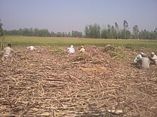
Kaland is a village in Meerut district. It is 6 km (3.7 mi) from Sardhana and 22 km (14 mi) from Meerut, The total geographical area of village is 543.199 hectares, It is famous for cane sugars and Gur sweets.
The Great Sherpur is a region or a pargana of 'Shankarwar Vansh' in the Mohammadabad tehsil of Ghazipur district in Uttar Pradesh. It consists of Sherpur Kalan, Sherpur Khurd, Semra, Firozpur, villages which were established by the descendants of Dullah Rai. It has population of 31322 as per 2011 Census.
Kandela is a village in Shamli district in the Indian state of Uttar Pradesh.
Chhai Pokhar is a village in the district of Agra in the Indian state of Uttar Pradesh. It is nearby Achhnera or Achnera, connected by road on three sides of the village and by rail. Khera Sandhan is the nearest railway station at about 1 km from the village on Agra- Achnera-Mathura section of NW Railway. It is also known as Three Towers' Village.
Sangaldan is a town near Ramban town in the Ramban district of the Indian union territory of Jammu and Kashmir. It falls in the Gool-Gulabgarh area of the Chenab valley.

Bhagipur is a village in Unchahar block of Raebareli district, Uttar Pradesh, India. It is located 34 km from Raebareli, the district headquarters. As of 2011, it has a population of 446 people, in 89 households.
Palaiyur is a village within the Indian state of Tamil Nadu. Palaiyur is located 282 kilometers from Chennai, in Kuttalam Taluk, which is in the Mayiladuthurai district and shares close border with the Thanjavur district. The current population is just under 2,000. Nearby villages include: Peravoor, Nakkambadi, S.Pudur, Kokkur, and Srikandapuram.
Sahara is a village in Bichpuri Block in Agra District of Uttar Pradesh State, India. It belongs to Agra Division. It is located 13 km towards west from District headquarters Agra. 3 km from Bichpuri. 356 km from State capital Lucknow

Padera, also spelled Pandera, is a village in Harchandpur block of Raebareli district, Uttar Pradesh, India. As of 2011, its population is 3,034, in 564 households. It has one primary school and no healthcare facilities.
Chebrolu is a village in West Godavari district of the Indian state of Andhra Pradesh. It is located in Unguturu mandal of Eluru revenue division. The nearest town is Tadepalligudem.The AH45 which runs from NH16 in Kolkata to NH48 in Bangalore passes by the village with beautiful Godavari canal on the other side.
Khandrawali is a large village located in Kairana tehsil of Shamli district in the Indian state of Uttar Pradesh.
Sanay is a village in Budaun district, Uttar Pradesh. Its village code is 128237. It is located on the right side of river Sot. Sanai is a medium size village located in Budaun of Budaun district, Uttar Pradesh with total 118 families residing. The Sanai village has population of 683 of which 366 are males while 317 are females as per Population Census 2011.
Manauri is a town of Prayagraj, Uttar Pradesh state of India. It is a market, 18 km west of Prayagraj city headquarter. It lies on the border of Prayagraj and Kaushambi district of Uttar Pradesh. On this town, a Railway Station lying nearby on the New Delhi - Howrah main line and an Air Force Station nearby on NH-2 is also named. Due to proximity of the Town with main Railway line and National highway, it has developed into a local trade market. The town has a huge population of more than 15 thousand, both of Hindus and Muslims. The main occupation is grains, vegetable and fruits agriculture along with traditional works like metal works, blacksmith, carpenter, glass works, and construction labours.

Taudhakpur, also known as Mirzapur Urf Taudhakpur, is a village located in Raebareli district, in the state of Uttar Pradesh, India. The village is 31 km from Raebareli and 87 km from Lucknow. As of 2011, the village had the population of 833 with 70.43% literacy rate. With the introduction of a digitized information center and modern-age communication facilities in 2018, Taudhakpur became the first smart village of India.