Khaypudyr Bay

Last updated
Location of Khaypudyr Bay in the Pechora Sea. Khaypudyr Bay.png
Location of Khaypudyr Bay in the Pechora Sea.

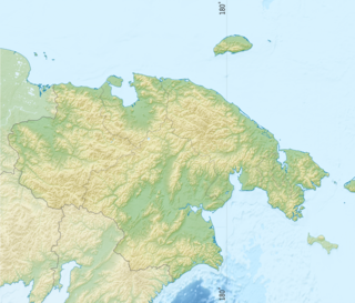
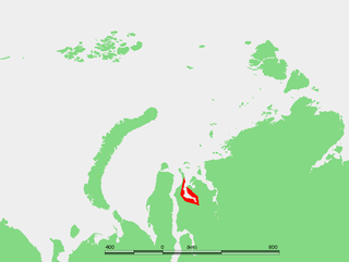
Khaypudyr Bay or Khaypudyrskaya Bay (Russian : Хайпудырская губа) is a gulf in Russia, located in the Pechora Sea (Southeastern Barents Sea) between the coastline of the Yugorsky Peninsula and the lowlands and marshy areas in the mainland south of Dolgiy Island. Its latitude is 68° 30' N and the longitude 59° 30' E.

Russian language East Slavic language

Russian is an East Slavic language, which is official in the Russian Federation, Belarus, Kazakhstan and Kyrgyzstan, as well as being widely used throughout Eastern Europe, the Baltic states, the Caucasus and Central Asia. It was the de facto language of the Soviet Union until its dissolution on 25 December 1991. Although nearly three decades have passed since the breakup of the Soviet Union, Russian is used in official capacity or in public life in all the post-Soviet nation-states, as well as in Israel and Mongolia.

Both headland and bay are two coastal features that are related and often found on the same coastline. A bay is a body of water—usually seawater and sometimes fresh water— mostly surrounded by land, whereas a headland is surrounded by water on three sides. Headlands are characterized by breaking waves, rocky shores, intense erosion and steep sea cliffs. Bays generally have less wave activity and typically have sandy beaches. Headlands and bays form on discordant coastlines, where the land consists of bands of rock of alternating resistance that run perpendicular to the coast.

Pechora Sea A marginal sea at the northwest of Russia, the southeastern part of the Barents Sea

Pechora Sea, is a sea at the northwest of Russia, the southeastern part of the Barents Sea. The western border of the sea is off Kolguyev Island, while the eastern border is the western coasts of Vaygach Island and the Yugorsky Peninsula, and the northern border the southern end of Novaya Zemlya.

The Khaypudyr Bay has a smaller bay within a larger one. The length of the wider gulf is approximately of 80 km, mouth width - 60 km. The smaller inner bay is often considered to be the Khaypudyr Bay proper. Its shape is rounder and it is located on the southwest shore of the larger one. Its length is 33 km and the width of its northward-facing mouth is 15 km. Its waters are very shallow, with an average depth between 1 and 2 m only.

The surface water temperature is 7C during summertime. The gulf freezes up during winter. The rivers Naulyakha, Talotayakha, Moreyu and Korotaikha flow into the Khaypudyr Bay.

This bay and its surroundings belong to the Nenets Autonomous Okrug administrative region of the Russian Federation, which is an autonomous okrug of Arkhangelsk Oblast.

Nenets Autonomous Okrug First-level administrative division of Russia

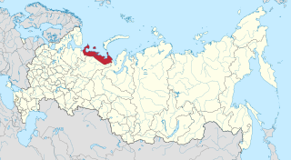
Nenets Autonomous Okrug is a federal subject of Russia. Its administrative center is the town of Naryan-Mar. It has an area of 176,700 square kilometers (68,200 sq mi) and a population of 42,090 as of the 2010 Census.

Arkhangelsk Oblast First-level administrative division of Russia

Arkhangelsk Oblast is a federal subject of Russia. It includes the Arctic archipelagos of Franz Josef Land and Novaya Zemlya, as well as the Solovetsky Islands in the White Sea. Arkhangelsk Oblast also has administrative jurisdiction over Nenets Autonomous Okrug. Including Nenetsia, Arkhangelsk Oblast has an area of 587,400 km2. Its population was 1,227,626 as of the 2010 Census.

Related Research Articles

Chukotka Autonomous Okrug First-level administrative division of Russia

Chukotka Autonomous Okrug or Chukotka (Чуко́тка) is a federal subject of Russia. It is geographically located in the Far East region of the country, and is administratively part of the Far Eastern Federal District. Chukotka is the 2nd-least-populated federal subject at 50,526 (2010) and the least densely populated.

Taganrog Bay bay

Taganrog Bay or Tahanrih Bay is the northeastern arm of the Sea of Azov. It also may be perceived as a flooded estuary of the Don River.

Ayon Island island

Ayon Island is an island in the coast of Chukotka in the East Siberian Sea. The island itself consists mainly of low-lying tundra, and is primarily populated by the Chukchi people, who use the tundra as pasture for their reindeer herds.

Khatanga Gulf bay

The Khatanga Gulf or Khatanga Bay is a large tidal estuary in the Laptev Sea. It is relatively narrow, its length being 220 km with a maximum width of 54 km.

Baydaratskaya Bay

Baydaratskaya Bay or Baydarata Bay is a gulf in Russia, located in the southern part of the Kara Sea between the coastline of the Northern termination of the Ural Mountains and Yamal Peninsula. The length of the gulf is approx. 180 km, mouth width - 78 km, depth - up to 20 m. Surface water temperature is 5-6C during summertime. The gulf freezes up during winter. The rivers Baydarata, Yuribey, Kara, and some others flow into the Baydarata Bay.

Kolyuchin Bay

Kolyuchin Bay is a large bay in the Chukchi Sea on the northern shore of the Chukotka Peninsula, Russia.

Shantar Islands Island group in Far Eastern Federal District, Russian Federation

The Shantar Islands are a group of fifteen islands located off the northwestern shore of the Sea of Okhotsk east of Uda Gulf and north of Academy Bay. Most of the islands have rugged cliffs, but they are of moderate height; the highest point in the island group is 720 metres. The name of the island group has its origins in the Nivkh language from the word ч’андь/č’and’’ meaning "to be white". The islands are currently uninhabited.

Oleny Island island in the Kara Sea

Oleny Island is a single island in the Kara Sea just a few kilometers offshore, north of the coast of one of the arms of the Gydan Peninsula in North Siberia. It is covered with tundra and swamps and it is 53 km in length and its average width is 27 km, having an area of 1197 km². Its latitude is 72° 24' N and the longitude 77° 45' E.

Kolyuchin Island island in Russia

Kolyuchin Island or Koliuchin Island is a small island in the Chukchi Sea. It is not far from the coast, being only 11 km (6.8 mi) from the northern shore of the Chukotka Peninsula. Its latitude is 67° 28' N and its longitude 174° 37' W.

Dolgy Island island

Dolgy Island is an island in the Pechora Sea, east of the Khaypudyr Bay. The landscape of the island is relatively flat with small lakes and tundra patches.

Palyavaam River Stream in Siberia

The Palyavaam River is a stream in Far East Siberia flowing in a roughly westward direction. It passes through the sparsely populated areas of the Siberian tundra and flows into the East Siberian Sea at the Chaunskaya Bay. Its mouth is very close to the mouth of the Chaun River.

Yenisei Gulf bay

The Yenisei Gulf is a large and long estuary through which the lower Yenisei River flows into the Kara Sea.

Taymyr Gulf Gulf of Kara Sea

The Taymyr Gulf is a gulf in the Kara Sea that includes the estuary of the Lower Taymyr River.

Khalmyer Bay

The Khalmyer Bay is a bay on the Siberian coast in the Kara Sea. It is located in the Gydan Peninsula and it is roughly 185 km long and 47 km wide at its widest point. Lat 71°30′ N, long 76° E.

Yuratski Bay

The Yuratski Bay is an inlet on the Siberian coast in the Kara Sea. It is located in the Gydan Peninsula and it is roughly 45 km long and 30 km wide at its widest point. Lat 71° 50’ N, long 77° 45’ E.

Sorevnovaniya Island island in Russia

Sorevnovaniya Island is an uninhabited island in the southern region of the Kara Sea. This island is located in the Sorevnovaniya Bay, east of the Mikhailov Peninsula.

Ush Island island in Russia

Ush Island is an island in the northern coast of Sakhalin. Ush Island is located between a shallow bay and the Sea of Okhotsk, at the mouth of the Sakhalin Gulf.

Neskynpilgyn Lagoon lagoon in Russia

The Neskynpil'gyn Lagoon is a shallow coastal lake in the Chukchi Sea at the northern shore of the Chukotka Peninsula, Russia. 30 km to the east is Kolyuchinskaya Bay and 25 km west, Cape Serdtse-Kamen.

Kara River river in Russia

The Kara River is a river draining to the Arctic Kara Sea in Northern Siberia. It flows through the Pay-Khoy Mountains in the Polar Ural region, and makes parts of the borders between the Yamalo-Nenets Autonomous Okrug. Nenets Autonomous Okrug and the Komi Republic

Donuzlav lake in Russia

Lake Donuzlav also referred to as Donuzlav Bay is the deepest lake of Crimea and biggest in Chornomorske Raion (47 km²). It is a protected landscape and recreational park of the Autonomous Republic of Crimea.

References

Coordinates: 68°30′N59°30′E / 68.5°N 59.5°E / 68.5; 59.5

Geographic coordinate system Coordinate system

A geographic coordinate system is a coordinate system that enables every location on Earth to be specified by a set of numbers, letters or symbols. The coordinates are often chosen such that one of the numbers represents a vertical position and two or three of the numbers represent a horizontal position; alternatively, a geographic position may be expressed in a combined three-dimensional Cartesian vector. A common choice of coordinates is latitude, longitude and elevation. To specify a location on a plane requires a map projection.