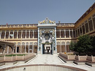
Ratlam is a city in the northwestern part of the Malwa region in Madhya Pradesh state of India. The city of Ratlam lies 480 metres (1,570 ft) above sea level. It is the administrative headquarters of Ratlam district, which was created in 1947 after the independence of India. It is located 294 kilometres west of the state capital Bhopal.

Jhunjhunu is a city in the state of Rajasthan in northern India and the administrative headquarters of Jhunjhunu District. Rajasthani and Hindi are widely spoken in Jhunjhunu. Jhunjhunu has given the highest number of soldiers to the Indian army and the paramilitary.udaipurwati and khetri tahsil was separated from Jhunjhunu and added to Neem Ka Thana.expect gudhagorji

Shekhawati is a semi-arid historical region located in the northeast part of Rajasthan, India. The region was ruled by Shekhawat Rajputs. Shekhawati is located in North Rajasthan, comprising the districts of Neem Ka Thana, Jhunjhunu, Sikar that lies to the west of the Aravalis and Churu. It is bounded on the northwest by the Bagar region, on the northeast by Haryana, on the east by Mewat, on the southeast by Dhundhar, on the south by Ajmer, and on the southwest by the Marwar region. Its area is 13,784 square kilometers.
Tal is a town and a nagar parishad in Ratlam District of the Indian state of Madhya Pradesh. Raja Tariya Bhil established Tal in 1243 AD. Bhil rulers ruled here till sixteen centuries.

Jakhal is a village located in the Nawalgarh tehsil of Jhunjhunu district of Rajasthan, India. It is located in shekhawati region, approx. 35 km south of Jhunjhunu city and 20 km east of Nawalgarh. Jakhal was founded by Salehadi Singh Shekhawat on 9 August 1732. Although hundreds of Jakhal's residents serve in the armed forces, the village's main occupation is farming. In the monsoon seasons, the main crops are bajara, moth, and guar, but in winter, the main crops are wheat, barley, sarson, and chana (chickpeas). The major part of the population belongs to Jat community with Moond, Khedar and garhwal Jat gotras.

Chomu is a town and municipality, near the city of Jaipur in Jaipur district in the state of Rajasthan, India.
Jirapur is a town and a nagar panchayat in Rajgarh district in the Indian state of Madhya Pradesh. In 2022 Janpad Panchayat election held across Madhya Pradesh, Congress won the election and secure position as a Janpad Adhyaksh under the leadership of Khilchipur vidhayak Shri Priyavrat Singh Ji. He put all the efforts to win this election and doing great work for Khilchipur constituency. He won 2018 assembly election of Madhya Pradesh with huge margin of 30,000+ votes by defeating Kunwar Hajarilal Dangi of Bharatiya Janata Party (BJP) candidate.
Khandela is a city and municipality in the Sikar district of the Indian state of Rajasthan.

Neem Ka Thana is a city and administrative headquarter of Neem Ka Thana district located 73 km from Sikar City in the Dhundhar region in the Rajasthan state of India. Sikar, Khandela, Sri Madhopur, Kotputli, Khetri, and Narnaul are some major cities and towns near Neem Ka Thana. It is located at a distance of 119 kilometers from Jaipur and 241 kilometers from Delhi. Neem Ka Thana is well connected with others cities in the region with roads and Indian Railways.

Sri Madhopur is a city and a municipality, in Neem Ka Thana district in the Indian state of Rajasthan. It was founded on 18 April 1761 under the reign of Maharaja Sawai Madho Singh I. It was mainly famous for his temples. Sri Madhopur Wheat market is the biggest wheat market in Neem ka thana district. Sri Madhopur Government school is one of the biggest school of the Neem Ka Thana district. It is one of the five tehsils of the district. Dedicated Delhi-Mumbai Freight Corridor is passing through this city. This city is chosen for the development of crossing station on this route.
Udaipurwati is a small town and a municipality in Neem Ka Thana in the Indian state of Rajasthan. Neem Ka Thana, Sikar, Sri Madhopur Khandela and Neem ka thana are some more developed towns near Udaipurwati. Udaipurwati (उदयपुरवाटी) is a town and tahsil in the Neem Ka Thana district in Rajasthan. Its ancient name, mentioned in Harsha Inscription 961 AD (L-39), was Udarbhatika (उदर्भटिका).
Vijaynagar or Vijaynagar is a town and a municipality in Sri Gangangaar district in the Indian state of Rajasthan.
Weir is a town and a municipality in Bharatpur District in the Indian state of Rajasthan.
Mundru is an old historical village in Sri Madhopur tehsil of Neem ka thana district of Rajasthan, India.
Maonda, is a small village located in Neem-Ka-Thana Khetri road Rajasthan, India. The village consists three small village. Directly connected with Delhi, Mumbai, Ajmer, Chandigarh by train, some of the major cities close to it include Sikar Alwar, Jaipur, Rohtak, and Hisar.
Khetri Assembly constituency is one of constituencies of Rajasthan Legislative Assembly in the Neem Ka Thana.
Sri Madhopur Assembly constituency is one of constituencies of Rajasthan Legislative Assembly in the Neem Ka Thana.

Dhosi is a village in Khetri subdistrict, Neem Ka Thana district, Rajasthan, India.
The village of Manaksas is located in Udaipurwati Tehsil of Neem Ka Thana district in the Indian state of Rajasthan, bordered by the Aravali Hills.
Ajeetgarh is a town located in Shrimadhopur tehsil in the Neem Ka Thana district of Rajasthan, India.


