Kibiro

Last updated

Kibiro is a small fishing village in Uganda that lies on the south-eastern shore of Lake Albert [1] The residents of the village are unable to produce their own agricultural products, and must trade with other communities for most of their necessities. [2] Residents of Kibiro support themselves primarily through the production and trade of salt. [3] Due to its cultural value, this site was added to the UNESCO World Heritage Tentative List on September 10, 1997. [4]

Contents

Geographical setting

Kibiro is located at the bottom of the Western Rift Valley on the Continent of Africa, and on the eastern shore of Lake Albert. [5] "Kibiro is in a rain shadow and has markedly less rain than the adjacent country" [5] It is known for having a windy and hot climate, with yearly temperatures ranging between 22.0 °C and 29.3 °C [1] “The coastal plain at Kibiro is in the shape of a triangle; with its base formed by the bottom of the escarpment it is appreciably wider than the narrow plain to its north-east, while to its south-west between Kibiro and Hoima there is in places no plain at all”. [6] “There is no road to Kibiro, the main access being a steep footpath down the escarpment. [7] The soil at Kibiro is shallow and rocky and the adjacent escarpment creates a local rain shadow. [8] The present village of Kibiro is a settlement of relatively scattered dwellings extending for several kilometers along the coastal plain. [8] It is divided into two main parts by the Mukihanga Valley: the larger part of the village lies to the south-west and is known as Bubare, the part to the north-east is known as Kihenda. [9] The coastal plain at Kibiro has two levels: a slightly higher area of gently sloping, usually stony ground that abuts the escarpment base; and a lower, flatter, often swampy, sand area adjacent to the lake but separated from it by two beach ridges. [10]

History

The production of salt in Kibiro is an important industry. [11] Kibiro’s economy revolves around salt. [11] “Without its salt industry Kibiro would probably be merely a small fishing village, lacking its extensive and deep archaeological deposits”. [12] The salt is produced exclusively by women. [8] “The production of salt at Kibiro is based on leaching of saline soil, the resulting brine is then boiled to evaporate the water”. [13] The process of salt production in Kibiro is a bit more sophisticated than others. [14] The process used to produce the salt in Kibiro constantly reuses the same soil. [11] “This recycling is accomplished by the repeated spreading of loose dry soil on the surface of a damp salt-bearing deposits, from which sun-induced capillary action draws out salty moisture”. [13] The process of winning the salt entailed techniques that were more tedious than the relatively simple harvesting methods employed at the crater lakes on the equator. [15] With the unique technique that is done to produce salt, it is believed that Kibiro will most likely never run out of salt, the only way in which the salt would run out is if the hot springs dry up, but before that is an actual possibility, it is believed that the salt-workers are more likely to run out of firewood. [16] The Bunyoro shore of Lake Albert has relatively few resources except the salt produced at Kibiro and formerly at other places. [17]

Salt-production process

No record of the salt-production process exists prior to the reports of Europeans in the 1800s. [11] The salt-production techniques described by early Europeans differ in many ways from the techniques employed by present-day Kibiro residents. [14]

Today in Kibiro, water from hot springs flows over the area's salty soil, keeping it moist. [14] Workers sprinkle dry earth over this, which draws the salt up from the earth. [11] The soil is then collected and placed in a sieve that is situated over a large pot. [11] Water is poured over the soil, and the water carries the salt into the pot. [14] This solution is then boiled to produce salt. [11]

Salt production in the area is done exclusively by women. [11]

Archaeology

The site of Kibiro has been of great interest to archaeologists because of its unique deposits that are found near western Uganda. [11] “The surface of the higher area of the Kibero coastal plain has a scatter of broken pottery that extends for over a kilometer from north-east to south-west”. [18] This is a unique for there is no place else that has the same “deep extensive, well-stratified occupation deposits created by iron-using agriculturalists over the last millennium”. [18] “The fragments of broken pottery, which are known locally as nkibo, form an almost continuous carpet on the Kihenda surface, much of which has only a thin grass cover”. [18] Salt manufactured from the springs at Kibero in western Bunyoro was distributed across Lake Albert by dugout canoes to populations in the Lendu area of the northeast Congo. [15] Kibero salt was obtained from saliferous earths. [15]

There was a series of excavations done in the small village of Kibiro by archaeologist Graham Connah. [14] Connah first excavated Kibiro in 1989. [16] The site of Kibero consisted of four discrete cuttings, which sampled three separated parts of the most extensive area of settlement deposits. [16] “The area in which the cutting took place is known as Kihenda, which is located between the two largest groups of salt-gardens and is said to be the oldest part of the village. [11]

The first cutting, excavated in early 1989, was only a test-hole, intended to gain a preliminary understanding of the deposits and their contents and to establish an initial radiocarbon chronology”. [16] The determination of where to do the first cutting was based on the assumption that the deposits that were shallower than 3 m but deeper than 0.8 m would lead to the finding of natural deposits. [11] In Cutting I the deposits excavated were in an irregular series of units, which contained ashy earth in the higher levels and sand, gravel, and silt towards the bottom levels. [19] There were fragments of wood charcoal as well as sherds of pottery. [11] In addition to the ecofacts, cultural remains that were uncovered in Cutting I were pieces of smoking pipes, disc beads of freshwater shell that were infrequently scattered, as well as two shell artifacts which consisted of a valve from the freshwater bivalve Mutela emini . [20] There was also animal bones that were discovered at the deposit. [20] With all of this being tied together with the other evidence found, indicated domestic activities as a major factor in their formation. [20]

Cutting II-IV were excavated in 1990; while Cutting I had been excavated in arbitrary splits; Cuttings II-IV were excavated in true stratigraphic units. [16] After they had excavated the site the work that Connah had done showed to have poor visibility of the stratification. [11] To get a better stratification they needed to acquire and take out certain blocks of deposits to help have a better view of the stratification. [16]

The main archaeological deposits at Kibiro seem to constitute a flat settlement mound of an irregular shape. [21]

Artifacts

At the site of Kibiro there were pottery sherds found. [22] There have been “sherds of pottery, stone grinders, grindstones, occasionally there have been beads, smoking-pipe fragments, cowry shells, pieces of freshwater shell and scraps of bone, both mammal and fish”. [18] In the two excavations that were done over 2 metric tonnes of broken pottery were recovered. [18] The current pottery found at Kibiro has a similar decoration as the sherds that were recovered. [18] The pottery of Kibiro had a decoration of knotted strip roulette and carved roulette, where the twisted string roulette is fundamentally missing. [23] The variation in the roulette patterns were more than just a type of decorations, they different types of roulette patterns also showed chronological variations at Kibiro. [23] As there seems to be much variation among the pottery of Kibiro, it seems unlikely that the pottery from this area was made here. [23] There have been similar forms of the type of pottery that is found at Kibiro in areas that neighbor it, with that it is believed that the pottery that was discovered at Kibiro was made somewhere else and brought into the village. [24]

There were other materials that were found when excavating at Kibiro. [25] Some of the other items that were found were iron, pieces of smoking pipes, as well as beads. The beads that were found were common to find while the excavations were being done. [25] The beads were generally disc beads of freshwater shell, and then later in the deposits there were ivory beads and a glass beads as well, which are rare to find, were also found. [25]

Apart from there being pottery and other cultural materials found at the Kibiro excavation site, there were also animal remains uncovered. [25] The majority of the animal remains were bones that appeared to be well preserved but were too shattered to be able to diagnosed. [26] The animal bones typically that the people of Kibiro relied on fish for a source of food as well as on domesticated cows, goats and/or sheep. [26] In addition to fish and cows, there were other wild animal remains found which were those of hare, various rodents, crocodile, snakes, frogs and birds, that are believed to have been supplemental to their diet or may have been included in the deposits for reasons that are not quite clear. [26]

Stratigraphy

The series of cutting that was done at Kibiro showed a series of stratified deposits that had accumulated over a period of 700–800 years up to the present and they seemingly resulted from both domestic and industrial activities. [22] When the cuttings were more closely examined, they found that Cuttings I, III and IV were all found to be horizontal but in comparison, Cutting II was found to be tilted, in areas that were very steep. [22] “Cutting II was located at the edge of what seemed the deepest archaeological deposits, revealed sloping rock rubble which had probably resulted from long continuance of the practice of removing stones from adjacent salt-gardens and heaping them out of the way”. [22] The other cuttings had a variety of thicknesses which were made up of earth, sand, gravel or silt, blended with stones that were different sizes and also had a phenomenal number of potsherds in the majority of the cases. [22] In the process of excavating Cutting II, there was one hearth that was discovered which was believed to have been used in the process for salt-boiling. [23] With the hearths being uncovered it also brought to light that the making of salt in Kibiro was produced throughout the occupation. [23] According to Graham Connah in his article published in 1991, he states that “because Cutting I was a limited test-hole, Cutting II had partly tilted deposits, and Cutting IV sampled the shallower part of the archaeological deposits near the edge of Lake Albert, Cutting III provides the most reliable and most complete stratified sequence. [23]

Discussion

With there being many excavations being done in Kibiro, one must be aware of the consequences that come with the archaeological work being done. [11] If it had not been for the salt industry, the village of Kibiro would have only been known as a small fishing village. [1] With there being a demand for the salt, it created the demand for people to want to go and live in the area to make be part of the industry. [11] There had to be some understanding that, “as time goes on the village population increases, it seems inevitable that more and more of the important Kibiro deposits will be destroyed by the digging of these pits”. [21] Though it is important to know the origins of an old kingdom, it comes at the cost of exploiting the resources that make the small village of Kibiro unique and cause it to no longer be the place in which the beginnings can be traced. [11]

Related Research Articles

<span class="mw-page-title-main">Ruins of Gedi</span> Archaeological site in Kenya

The ruins of Gedi are a historical and archaeological site near the Indian Ocean coast of eastern Kenya. The site is adjacent to the town of Gedi in the Kilifi District and within the Arabuko-Sokoke Forest.

<span class="mw-page-title-main">Ras Hafun</span> Easternmost point of Africa, in Somalia

Ras Hafun, also known as Cape Hafun, is a promontory in the northeastern Bari region of Somalia. Jutting out into the Guardafui Channel, it constitutes the easternmost point in Africa. The area is situated near the Cape Guardafui headland. It is joined to the mainland at the town of Foar, by a sand spit 20.0 km (12.4 mi) long, 1.0–3.0 km (0.62–1.86 mi) in width, and 5.0 m (16.4 ft) above sea level. The fishing town of Hafun is located on the promontory, 2.0 km (1.2 mi) east of the sand spit.

<span class="mw-page-title-main">Ingombe Ilede</span> Archaeological site in Zambia

Ing'ombe Ilede is an archaeological site located on a hill near the confluence of the Zambezi and Lusitu rivers, near the town of Siavonga, in Zambia. Ing'ombe Ilede, meaning "a sleeping cow", received its name from a local baobab tree that is partially lying on the ground and resembles a sleeping cow from a distance. The site is thought to have been a small commercial state around the 16th century whose chief item of trade was salt. Ing'ombe Ilede received various goods from the hinterland of south-central Africa, such as, copper, slaves, gold and ivory. These items were exchanged with glass beads, cloth, cowrie shells from the Indian Ocean trade. The status of Ing'ombe Ilede as a trading center that connected different places in south-central Africa has made it a very important archaeological site in the region.

Mumba Cave, located near the highly alkaline Lake Eyasi in Karatu District, Arusha Region, Tanzania. The cave is a rich archaeological site noted for deposits spanning the transition between the Middle Stone Age and Late Stone Age in Eastern Africa. The transitional nature of the site has been attributed to the large presence of its large assemblage of ostrich eggshell beads and more importantly, the abundance of microlith technology. Because these type artifacts were found within the site it has led archaeologists to believe that the site could provide insight into the origins of modern human behavior. The cave was originally tested by Ludwig Kohl-Larsen and his wife Margit in their 1934 to 1936 expedition. They found abundant artifacts, rock art, and burials. However, only brief descriptions of these findings were ever published. That being said, work of the Kohl-Larsens has been seen as very accomplished due to their attention to detail, especially when one considers that neither was versed in proper archaeological techniques at the time of excavation. The site has since been reexamined in an effort to reanalyze and complement the work that has already been done, but the ramifications of improper excavations of the past are still being felt today, specifically in the unreliable collection of C-14 data and confusing stratigraphy.

<span class="mw-page-title-main">Tas-Silġ</span> Multi-period sanctuary and archaeological site

Tas-Silġ is a rounded hilltop on the south-east coast of the island of Malta, overlooking Marsaxlokk Bay, and close to the town of Żejtun. Tas-Silġ is a major multi-period sanctuary site with archaeological remains covering four thousand years, from the neolithic to the ninth century AD. The site includes a megalithic temple complex dating from the early third millennium BC, to a Phoenician and Punic sanctuary dedicated to the goddess Astarte. During the Roman era, the site became an international religious complex dedicated to the goddess Juno, helped by its location along major maritime trading routes, with the site being mentioned by first-century BC orator Cicero.

Unguja Ukuu is a historic Swahili settlement on Unguja island, in Zanzibar, Tanzania.

<span class="mw-page-title-main">Kʼaxob</span>

Kʼaxob is an archaeological site of the Maya civilization located in Belize. It was occupied from about 800 B.C. to A.D. 900. The site is located in northern Belize in the wetlands of Pulltrouser Swamp in proximity to the Sibun River Valley in central Belize. Research has shown that Kʼaxob was occupied from the Late Preclassic Period to the Early Postclassic Period. This period in time and the site is characterized by specific ceramic types as well as agriculture and an increase in social stratification. Kʼaxob is a village site centered on two pyramid plazas and later grew in size during the Early Classic Period to the Late Classic Period. The site includes a number of household, mounds and plazas. Kʼaxob is mostly based on residential and household living but also has some ritualistic aspects. Many of the structures at the site show evidence of household dwellings as well as ritual purposes. There are many burials at the site that illustrate the ritualistic aspects and social stratification at Kʼaxob. Many of the individuals, some more than others, were interned with beads made of shell as well as ceramic vessels, demonstrating this potential social stratification. The pottery vessels recovered from the site demonstrates regularity in the production of pottery. The most prominent type of ceramic vessels recovered from the site were 'serving bowls', with a tripodal base, and were present during the Early Classic Period. There is also evidence of specialized areas for pottery production. There are middens at the site that yielded a great deal of pottery sherds and are associated with structures that are believed to be kilns as well as with tools similar to modern pottery making tools. There is also some evidence of stone tool production at the site. The most common stone tool recovered from the site is a chert oval biface and is associated with agriculture and thought to have been used for weeding and hoeing.

<span class="mw-page-title-main">Knap Hill</span> Earthwork in Wiltshire, England

Knap Hill lies on the northern rim of the Vale of Pewsey, in northern Wiltshire, England, about a mile north of the village of Alton Priors. At the top of the hill is a causewayed enclosure, a form of Neolithic earthwork that was constructed in England from about 3700 BC onwards, characterized by the full or partial enclosure of an area with ditches that are interrupted by gaps, or causeways. Their purpose is not known—they may have been settlements, or meeting places, or ritual sites of some kind. The site has been scheduled as an ancient monument.

The Kalemba Rockshelter is an archaeology site located in eastern Zambia, at coordinates 14°7 S and 32°3 E. Local tradition recalls the use of the rock shelter as a refuge during the time of Ngoni raiding in the 19th century. The site is known for various rock paintings as well as advanced microlithic use.

Bigo bya Mugenyi, also Bigo, is an extensive alignment of ditches and berms comprising ancient earthworks located in the interlacustrine region of southwestern Uganda. Situated on the southern shore of the Katonga River, Bigo is best described as having two elements. The first consists of a long, irregular ditch and bank alignment with multiple openings that effectively creates an outer boundary by connecting to the Katonga River in the east and the Kakinga swamp to the west. Toward its eastern end the outer ditch branches further to the east to encompass a nearby crossing of the Katonga River. The second element consists of a central, interconnected group of four irregularly shaped ditch and bank enclosures that are connected to the Katonga River by a single ditch. Three mounds are associated with the central enclosures; two within and one immediately to the west. When combined, the Bigo earthworks extend for more than 10 kilometers. Resulting from radiometric dates collected from archaeological investigations conducted in 1960 and additional investigations undertaken at the Mansa earthworks site in 1988, 1994, and 1995, the Bigo earthworks have been dated to roughly AD 1300-1500, and have been called Uganda's "largest and most important ancient monument."

Ntusi is a Late Iron Age archaeological site located in southwestern Uganda that dates from the tenth century to the fifteenth century AD. Ntusi is dominated by two large mounds and manmade scraped valley basins called, bwogero. Long abandoned by the time Hima herdsman grazed their cattle on the Bwera, the herdsman named the site "Ntusi" meaning, "the mounds", after the prominent earthworks. The archaeological record at Ntusi is unmistakable in the signs of intense occupation and activity and it represents the beginning of political complexity in this region of Africa. Bigo bya Mugenyi, another site with prominent earthworks, lies 13 km to the north of Ntusi.

Ngamuriak is an archaeological site located in south-western Kenya. It has been interpreted as an Elmenteitan Pastoral Neolithic settlement. The excavation of this site produced pottery sherds, stone tools with obsidian fragments and obsidian blades, along with large amounts of animal bones.

The Gwisho hot-springs are an archaeological site in Lochinvar National Park, Zambia. The location is a rare site for its large quantity of preserved animal and plants remains. The site was first excavated by J. Desmond Clark in 1957, who found faunal remains and quartz tools in the western end of the site.

Shanga is an archaeological site located in Pate Island off the Eastern Coast of Africa. The site covers about 15 hectares. Shanga was excavated during an eight-year period in which archaeologists examined Swahili origins. The archaeological evidence in the form of coins, pottery, glass and beads all suggest that a Swahili community inhabited the area during the eighth century. Evidence from the findings also indicates that the site was a Muslim trading community that had networks in Asia.
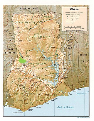
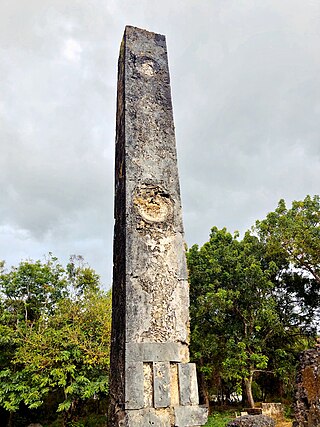
This page is a glossary of archaeology, the study of the human past from material remains.

The Carcajou Point site is located in Jefferson County, Wisconsin, on Lake Koshkonong. It is a multi-component site with prehistoric Upper Mississippian Oneota and Historic components.

Torbulok is an archaeological site located in a foothill zone 50 km northwest of the Kyzylsu river valley and 20 km southeast of Danghara in the south of present-day Tajikistan. The site lies at the foot of the Čaltau mountain range. It was the site of a small sanctuary during the Hellenistic period, when the area was part of the Greco-Bactrian kingdom.

<span class="mw-page-title-main">Mlambalasi Rock Shelter</span> National Historic Site of Tanzania

The Mlambalasi Rock Shelter is a historic site located in Iringa District of Iringa Region in southern Tanzania, 50 km away from Iringa City. Excavations in 2006 and 2010 by the Iringa Region Archaeological Project uncovered artifactual deposits from the Later Stone Age (LSA), the Iron Age, and the historic periods, as well as external artifacts from the Middle Stone Age (MSA). Direct dating on Achatina shell and ostrich eggshell beads indicates that the oldest human burials at Mlambalasi are from the terminal Pleistocene. Mlambalasi is characterized by interment LSA and Iron Age periods, as well as by cycles of use and abandonment.

Rwanda's prehistory is a relatively unexplored concept as compared to other regions of Africa. Most archaeological works regarding Rwanda past 1994 are associated with conflict and ethnic violence. However more recently, archaeologists have been attempting to focus on archaeological works from the first and second millennia A.D. For example, some archaeological research has been focusing on the Nyiginya Kingdom, which is the pre-colonial predecessor of the current Rwandan state. Other research has been focusing on the excavations of the earliest agricultural sites, likely from the Iron Age, as well as ceramics to indicate chronology of when certain agricultural groups migrated to Rwanda.

Daima is a mound settlement located in Nigeria, near Lake Chad, and about 5 kilometers away from the Nigerian frontier with Cameroon. It was first excavated in 1965 by British archaeologist Graham Connah. Radiocarbon dating showed the occupations at Daima cover a period beginning early in the first millennium BC, and ending early in the second millennium AD. The Daima sequence then covers some 1800 years. Daima is a perfect example of an archaeological tell site, as Daima’s stratigraphy seems to be divided into three periods or phases which mark separate occupations. These phases are called Daima I, Daima II, and Daima III. Although these occupations differ from each other in multiple ways, they also have some shared aspects with one another. Daima I represents an occupation of a people without metalwork; Daima II is characterized by the first iron-using people of the site; and Daima III represents a rich society with a much more complex material culture.

References

  1. 1 2 3 Connah, Graham (1996). Kibiro; The Salt of Bunyoro, Past and Present. London: British Institute of Eastern Africa. p. 6.
  2. Connah, Graham (1996). Kibiro; The Salt of Bunyoro, Past and Present. London: British Institute of Eastern Africa. p. 8.
  3. Centre, UNESCO World Heritage. "Kibiro (Salt producing village) - UNESCO World Heritage Centre". whc.unesco.org. Retrieved 2016-03-19.
  4. Kibiro (Salt producing village) - UNESCO World Heritage Centre
  5. 1 2 Connah, Graham (1996). Kibiro; The Salt of Bunyoro, Past and Present. London: The British Institute of Eastern Africa. p. 6.
  6. Connah, Graham (1996). Kibiro: The salt of Bunyoro, past and present. The British Institute in Eastern Africa. p. 12.
  7. Connah, Graham (1996). Kibiro: The salt of Bunyoro, past and present. The British Institute in Eastern Africa. p. 16.
  8. 1 2 3 Connah, Graham (1991). "The salt of Bunyoro: seeking the origins of an African kingdom". Antiquity: 481.
  9. Connah, Graham (1996). Kibiro: The salt of Bunyoro, past and present. The British Institute in Eastern Africa. p. 14.
  10. Connah, Graham (1996). Kibiro: The salt of Bunyoro, past and present. The British Institute in Eastern Africa. p. 13.
  11. 1 2 3 4 5 6 7 8 9 10 11 12 13 14 15 16 Connah, Graham (1996). Kibiro The Salt of Bunyoro, Past and Present. London: British Institute in Eastern Africa.
  12. Connah, Graham (1996). Kibiro: The salt of Bunyoro, past and present. The British Institute in Eastern Africa. p. 37.
  13. 1 2 Connah, Graham (1996). Kibiro: The salt of Bunyoro, past and present. The British Institute in Eastern Africa. p. 38.
  14. 1 2 3 4 5 Connah, Gragam (1990). "Salt-production at Kibiro". Journal of the British Institute in Eastern Africa.
  15. 1 2 3 Good, Charles M (1972). "Salt, Trade, and Disease: Aspects of Development in Africa's Northern Great Lakes Region". The International Journal of African Historical Studies: 565.
  16. 1 2 3 4 5 6 Connah, Graham (1991). "The salt of Bunyoro: seeking the origins of an African kingdom". Antiquity: 485.
  17. Connah, Graham (1996). Kibiro: The salt of Bunyoro, past and present. The British Institute in Eastern Africa. p. 10.
  18. 1 2 3 4 5 6 Connah, Graham (1996). Kibiro: The salt of Bunyoro, past and present. The British Institute in Eastern Africa. p. 56.
  19. Connah, Graham (1996). Kibiro: The salt of Bunyoro, past and present. The British Institute in Eastern Africa. p. 66.
  20. 1 2 3 Connah, Graham (1996). Kibiro: The salt of Bunyoro, past and present. The British Institute in Eastern Africa. p. 67.
  21. 1 2 Connah, Graham (1996). Kibiro: The salt of Bunyoro, past and present. The British Institute in Eastern Africa. p. 57.
  22. 1 2 3 4 5 Connah, Graham (1991). "The salt of Bunyoro: seeking the origins of an African kingdom". Antiquity: 486.
  23. 1 2 3 4 5 6 Connah, Graham (1991). "The salt of Bunyoro: seeking the origins of an African kingdom". Antiquity: 487.
  24. Connah, Graham (1991). "The salt of Bunyoro: seeking the origins of an African kingdom". Antiquity: 488.
  25. 1 2 3 4 Connah, Graham (1991). "The salt of Bunyoro: seeking the origins of an African kingdom". Antiquity: 488–489.
  26. 1 2 3 Connah, Graham (1991). "The salt of Bunyoro: seeking the origins of an African kingdom". Antiquity: 489.

Coordinates: 1°40′27″N31°15′09″E / 1.67417°N 31.25250°E / 1.67417; 31.25250