
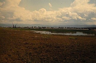
Babushkin, known as Mysovsk (Мысовск) before 1941, is a town in Kabansky District of the Republic of Buryatia, Russia, located on the southern shore of Lake Baikal on the Trans-Siberian Railway. Population: 4,831 (2010 Census); 4,953 (2002 Census); 7,298 (1989 Census); 9,000 (1967).

Kamensk is an urban locality in Kabansky District of the Republic of Buryatia, Russia. As of the 2010 Census, its population was 7,160.
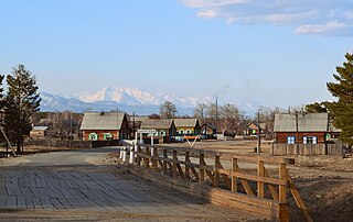
Ust-Barguzin is an urban locality in Barguzinsky District of the Republic of Buryatia, Russia, located on the shore of Lake Baikal at the mouth of the Barguzin River and 270 kilometers (170 mi) northeast of Ulan-Ude, the capital of the republic. As of the 2010 Census, its population was 7,173.

Taksimo is an urban locality and the administrative center of Muysky District of the Republic of Buryatia, Russia, located on the Muya River on the Muysk Plateau in the far northeast of the republic. As of the 2010 Census, its population was 9,438.
Severo-Baykalsky District is an administrative and municipal district (raion), one of the twenty-one in the Republic of Buryatia, Russia. It is located in the northeast of the republic. The area of the district is 54,000 square kilometers (21,000 sq mi). Its administrative center is the urban locality of Nizhneangarsk. As of the 2010 Census, the total population of the district was 14,035, with the population of Nizhneangarsk accounting for 35.8% of that number.

Nizhneangarsk is an urban locality and the administrative center of Severo-Baykalsky District of the Republic of Buryatia, Russia, located at the northern tip of Lake Baikal, 23 kilometers (14 mi) north of Severobaykalsk. As of the 2010 Census, its population was 5,030.

Novy Uoyan is an urban locality in Severo-Baykalsky District of the Republic of Buryatia, Russia, located in the basin of the Upper Angara River, 550 kilometers (340 mi) from Ulan-Ude, the capital of the republic. As of the 2010 Census, its population was 3,963.

Kabansky District is an administrative and municipal district (raion), one of the twenty-one in the Republic of Buryatia, Russia. It is located in the center of the republic. The area of the district is 13,470 square kilometers (5,200 sq mi). Its administrative center is the rural locality of Kabansk. As of the 2010 Census, the total population of the district was 59,883, with the population of Kabansk accounting for 10.1% of that number.
Kurumkansky District is an administrative and municipal district (raion), one of the twenty-one in the Republic of Buryatia, Russia. It is located in the northeast of the republic. The area of the district is 12,450 square kilometers (4,810 sq mi). Its administrative center is the rural locality of Kurumkan. As of the 2010 Census, the total population of the district was 15,007, with the population of Kurumkan accounting for 36.4% of that number.

Kyakhtinsky District is an administrative and municipal district (raion), one of the twenty-one in the Republic of Buryatia, Russia. It is located in the south of the republic. The area of the district is 4,684 square kilometers (1,809 sq mi). Its administrative center is the town of Kyakhta. As of the 2010 Census, the total population of the district was 39,785, with the population of Kyakhta accounting for 50.3% of that number.

Muysky District is an administrative and municipal district (raion), one of the twenty-one in the Republic of Buryatia, Russia. It is located in the northeast of the republic. The area of the district is 25,164.1 square kilometers (9,715.9 sq mi). Its administrative center is the urban locality of Taksimo. As of the 2010 Census, the total population of the district was 13,142, with the population of Taksimo accounting for 71.8% of that number.

Selenginsky District is an administrative and municipal district (raion), one of the twenty-one in the Republic of Buryatia, Russia. It is located in the center of the republic. The area of the district is 8,269 square kilometers (3,193 sq mi). Its administrative center is the town of Gusinoozyorsk. As of the 2010 Census, the total population of the district was 46,427, with the population of Gusinoozyorsk accounting for 52.9% of that number.

Zaigrayevsky District is an administrative and municipal district (raion), one of the twenty-one in the Republic of Buryatia, Russia. It is located in the center of the republic. The area of the district is 6,605 square kilometers (2,550 sq mi). Its administrative center is the urban locality of Zaigrayevo. As of the 2010 Census, the total population of the district was 49,975, with the population of Zaigrayevo accounting for 11.2% of that number.

Zakamensky District is an administrative and municipal district (raion), one of the twenty-one in the Republic of Buryatia, Russia. It is located in the southwest of the republic. The area of the district is 15,320 square kilometers (5,920 sq mi). Its administrative center is the town of Zakamensk. As of the 2010 Census, the total population of the district was 28,453, with the population of Zakamensk accounting for 40.5% of that number.
Naushki is an urban locality in Kyakhtinsky District of the Republic of Buryatia, Russia, located near the border with Mongolia, 30 kilometers (19 mi) from the town of Kyakhta. As of the 2010 Census, its population was 3,409.

Selenginsk is an urban locality in Kabansky District of the Republic of Buryatia, Russia, located at the head of the Selenga River delta about 30 kilometers (19 mi) from Lake Baikal and about 50 kilometers (31 mi) northwest of Ulan-Ude, the capital of the republic. As of the 2010 Census, its population was 14,546.
Severomuysk is an urban locality in Muysky District of the Republic of Buryatia, Russia, located about 90 kilometers (56 mi) southwest of the urban-type settlement of Taksimo, the administrative center of the district. As of the 2010 Census, its population was 2,198.

Yanchukan is an urban locality in Severo-Baykalsky District of the Republic of Buryatia, Russia. As of the 2010 Census, its population was 392.
Zaigrayevo is an urban locality and the administrative center of Zaigrayevsky District of the Republic of Buryatia, Russia. As of the 2010 Census, its population was 5,586.
Onokhoy is an urban locality in Zaigrayevsky District of the Republic of Buryatia, Russia. As of the 2010 Census, its population was 10,689.


