
Killendoon is a rural locality of Warren Shire and is in the civil parish of County of Ewenmar. Killendoon is on the Ewenma Creek Macquarie River outside Warren, New South Wales.
Killendoon is a rural locality of Warren Shire and is in the civil parish of County of Ewenmar. Killendoon is on the Ewenma Creek Macquarie River outside Warren, New South Wales.
Before European settlement the area is said to have been occupied by the Ngiyambaa Aborigines. Explorer John Oxley camped on the present town site during his investigation of the Macquarie River in 1818. He noted an abundance of kangaroos and emus. Charles Sturt carried out further exploration in 1828–29. Cattle were grazing hereabouts by the late 1830s. [1]
Warren station was established in 1845 by Thomas Readford and William Lawson, the son of explorer William Lawson who was a member of the first European party to breach the Blue Mountains in 1813. Some say the name derives from a local Aboriginal word, meaning "strong" or "substantial". Another theory is that it represents the adoption of a contemporary English term, "warren", meaning a game park - perhaps a reference to the picturesque riverside setting where the station hut was built (on what is now Macquarie Park) and to the large numbers of wildlife in the area.
A post office opened in 1861, a bootmaker's shop (made of bark) in 1863, a store in 1866, a school in 1867, an Anglican church in 1873, the first courthouse in 1874 and the first bridge in 1875. However, closer settlement did not really develop until the late 1880s.
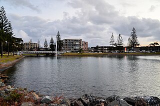
Warren was incorporated as a municipality in 1895 and the Warren Weir was established in 1896. The town benefited greatly with the arrival of the railway in 1898, making it the rail head for an enormous area. In general terms, its prosperity rose and fell with the price of wool. In the 1920s the town developed quite substantially. In the Great Depression the economy shrank, expanding again in the postwar years. The eternal water shortage was greatly eased when Burrendong Dam was opened in 1967, allowing the development of cotton and produce.

William Lawson was an English-born Australian explorer, land owner, grazier and politician who migrated to Sydney, New South Wales in 1800. Along with his close friends and colleagues Gregory Blaxland and William Wentworth, he pioneered the first successful crossing of the Blue Mountains by European settlers.

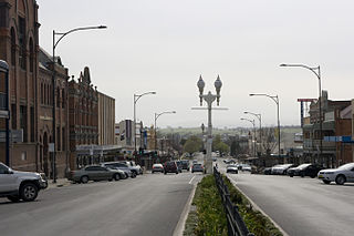
Warren is a town in the Orana Region of New South Wales, Australia. It is located on the Oxley Highway, 120 kilometres north west of Dubbo, and is the seat of the Warren Shire local government area. At the 2016 census, Warren had a population of 1,530. Warren is included in the Central West Slopes and Plains division of the Bureau of Meteorology forecasts.

Macquarie River a watercourse that is part of the Macquarie–Barwon catchment within the Murray–Darling basin, is one of the main inland rivers in New South Wales, Australia.

Mudgee is a town in the Central West of New South Wales, Australia. It is in the broad fertile Cudgegong River valley 261 km (162 mi) north-west of Sydney. Mudgee is at the centre of the Mid-Western Regional Council local government area. As at June 2018 Mudgee had a population of 12,410.
Port Macquarie is a coastal town in the local government area of Port Macquarie-Hastings. It is located on the Mid North Coast of New South Wales, Australia, about 390 km (242 mi) north of Sydney, and 570 km (354 mi) south of Brisbane. The town is located on the Tasman Sea coast, at the mouth of the Hastings River, and at the eastern end of the Oxley Highway (B56). The town with its suburbs had a population of 47,973 in June 2018.

Junee is a medium-sized town in the Riverina region of New South Wales, Australia. The town's prosperity and mixed services economy is based on a combination of agriculture, rail transport, light industry and government services, and in particular correctional services. In 2015 Junee's urban population was 4,762.

George William Evans was a surveyor and early explorer in the Colony of New South Wales. Evans was born in Warwick, England, migrating to Australia in October 1802.

The Castlereagh River is located in the central–western district of New South Wales, Australia. It is part of the Macquarie-Castlereagh catchment within the Murray–Darling basin and is an unregulated river, meaning no dams or storage have been built on it to control flows. On a map of NSW, the Castlereagh has a distinctive appearance among the north-western rivers for its fish-hook-like shape: from upstream in the north at its confluence with the Macquarie River it extends southwards to a hook-shape, flattened-out at the base, which curves to the right through to the tip of the hook in the Warrumbungle Mountains at the river's source.
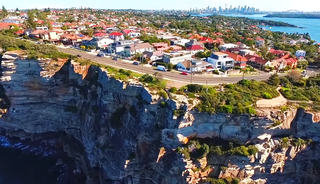
Vaucluse is an eastern suburb of Sydney, in the state of New South Wales, Australia. It is located 8 kilometres (5 mi) north-east of the Sydney central business district, in the local government areas of Waverley Council and the Municipality of Woollahra.

Paterson is a small township in the lower Hunter Region of New South Wales, Australia. Located within Dungog Shire it is situated on the Paterson River. It is in the middle of what was once dairy, timber and citrus country and is now more significantly a feeder town for the nearby mining industry in the Upper Hunter and the city of Newcastle It was named after one of the first known Europeans in the area was Colonel William Paterson in 1801 surveyed the area beside the river.
The history of New South Wales refers to the history of the Australian state of New South Wales and the area's preceding Indigenous and British colonial societies. The Mungo Lake remains indicate occupation of parts of the New South Wales area by Indigenous Australians for at least 40,000 years. The English navigator James Cook became the first European to map the coast in 1770 and a First Fleet of British convicts followed to establish a penal colony at Sydney in 1788.

Nathalia is a town in northern Victoria, Australia. The town is located within the Shire of Moira local government area on the banks of Broken Creek and on the Murray Valley Highway. At the 2011 census, Nathalia had a population of 1,902.

The 1813 crossing of the Blue Mountains was the expedition led by Gregory Blaxland, William Lawson and William Charles Wentworth, which became the first successful crossing of the Blue Mountains in New South Wales by European settlers. The crossing enabled the settlers to access and use the land west of the mountains for farming, and made possible the establishment of Australia's first inland settlement at Bathurst.
European land exploration of Australia deals with the opening up of the interior of Australia to European settlement which occurred gradually throughout the colonial period, 1788–1900. A number of these explorers are very well known, such as Burke and Wills who are well known for their failed attempt to cross the interior of Australia, as well as Hamilton Hume and Charles Sturt.

The European exploration of Australia first began in February 1606, when Dutch navigator Willem Janszoon landed in Cape York Peninsula and on October that year when Spanish explorer Luís Vaz de Torres sailed through, and navigated, Torres Strait islands. Twenty-nine other Dutch navigators explored the western and southern coasts in the 17th century, and dubbed the continent New Holland.

Carual, New South Wales also known as Carval is a civil parish and rural locality of New South Wales located at 31°37'54.0"S 147°44'04.0"E.
Egelabra, New South Wales is a civil parish and rural locality of New South Wales located at 31°47′54″S 147°50′04″E.
Ganalgang, New South Wales is a civil parish and rural locality of New South Wales located at 31°49′54″S 147°56′04″E.
Driel is a rural locality of Warren Shire 31°39′54″S 147°56′04″E a few miles north of Warren, New South Wales Driel is also a civil Parish]] of Ewenmar County, a cadastral division of New South Wales.
The Bathurst Street Lamps are heritage-listed street lights located in the Bathurst central business district in the Bathurst Region, New South Wales, Australia. They were built from 1872 to 1924. They were added to the New South Wales State Heritage Register on 1 August 2003. There are 105 lights in total that are located on Howick, William, George, Keppel, Russell, and Church Streets, in King's Parade, and in Machattie Park.
| This Central West geography article is a stub. You can help Wikipedia by expanding it. |