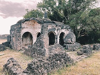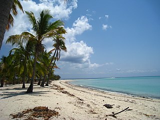
Kilwa Kisiwani is an island, national historic site, and hamlet community located in the township of Kilwa Masoko, the district seat of Kilwa District in the Tanzanian region of Lindi in southern Tanzania. Kilwa Kisiwani is the largest of the nine hamlets in the town of Kilwa Masoko and is also the least populated hamlet in the township with fewer than 1,000 residents.

Kilwa District is one of six administrative districts of Lindi Region in Tanzania. The District covers an area of 15,000 km2 (5,800 sq mi). The district is comparable in size to the land area of the nation state of East Timor. Kilwa district is bordered to the north by Rufiji District in Pwani Region, to the east by the Indian Ocean, to the south by the Lindi District, Nachingwea District together with Ruangwa District, and to the west by the Liwale District. The district borders every other district in Lindi Region except Lindi Municipal District. The district seat (capital) is the town of Kilwa Masoko. The district is named after the medieval Swahili city state of Kilwa Kisiwani. According to the 2012 census, the district has a total population of 190,744. By 2022, the population had increased to 297,676.

Lindi Region is one of Tanzania's 31 administrative regions. The region covers an area of 66,040 km2 (25,500 sq mi). The region is comparable in size to the combined land area of the nation state of Sri Lanka. The regional capital is the municipality of Lindi.

Lindi District also known as Mtama District is one of six administrative districts of Lindi Region in Tanzania. The District covers an area of 5,975 km2 (2,307 sq mi). Kilwa district is bordered to the north by Kilwa District, to the east by the Indian Ocean and Lindi Municipal District, to the south by the Mtwara Region, and to the west by the Nachingwea District. The district seat (capital) is the town and ward of Mtama. The district is known for the Tendaguru Formation, the richest Late Jurassic strata of fossils in Africa. According to the 2012 census, the district has a total population of 191,143.

Kilwa Masoko or Masoko is an administrative ward in Kilwa District of Lindi Region in Tanzania. The ward covers an area of 200 km2 (77 sq mi), and has an average elevation of 11 m (36 ft). The ward is also the capital of Kilwa District. According to the 2012 census, the ward has a total population of 13,601.
Lindi Airport is an airport serving Lindi, the capital of the Lindi Region of Tanzania. It is also known as Kikwetu Airport.

Musoma Airport is an airport in northern Tanzania serving Musoma and the surrounding Mara Region.

Mafia Airport is an airport on Mafia Island in the Mafia District of Pwani Region in Tanzania. The island is located in the Sea of Zanj in the Indian Ocean, 17 kilometres (11 mi) across the Mafia Channel on the Tanzanian mainland coast. In 2013 the landing strip at Mafia Airport was rehabilitated using grant funds provided by the United States government through the Millennium Challenge Corporation. The Mafia non-directional beacon is located on the field.
Mpanda Airport is an airport in western Tanzania serving the town of Mpanda and the surrounding Katavi Region. It is on the southeastern side of the town. The UN Refugee Agency UNHCR helped the Government of Tanzania to finance the upgrade of the airstrip into an airport as a gesture of its appreciation for hosting Burundian refugees for more than 30 years.

Iringa Airport is an airport in Tanzania serving Iringa and the surrounding Iringa Region. It is 13 kilometres (8.1 mi) northeast of the municipality. The airport's single runway lies parallel to the A104 trunk road.
Masasi Airport is an airport serving the town of Masasi in the Mtwara Region of Tanzania. It is 3 kilometres (1.9 mi) west of Masasi town.
Nachingwea Airport is a domestic airport locate in south Lindi Region, Tanzania. The airport serves the town Nachingwea. It is on the northeast side of the town.
Mbeya Airport is an airport located in Mbeya Region, Tanzania. The airport is small and serves the city of Mbeya. It is within the southern section of the city.

Seronera Airstrip is the primary airstrip in the Serengeti National Park.

Songo Songo Island, or sometimes spelled Songosongo Island, is a coral island in the Songosongo Archipelago. The island is governed by the Songosongo ward in Kilwa District of Lindi Region in Tanzania's Indian ocean coast. It is served by the Songo Songo Airstrip. The island's native inhabitants are the Matumbi people.
Chumo is an administrative ward in Kilwa District of Lindi Region in Tanzania. The ward covers an area of 271 km2 (105 sq mi), and has an average elevation of 277 m (909 ft). According to the 2012 census, the ward has a total population of 13,897. The ward seat is Chumo.
Lihimalyao is an administrative ward in Kilwa District of Lindi Region in Tanzania. The ward covers an area of 360.4 km2 (139.2 sq mi), and has an average elevation of 39 m (128 ft). According to the 2022 census, the ward has a total population of 13,767. The ward seat is Lihimalyao village. Lihilmalyao ward is also the mouth of Lindi's largest and longest river, the Mbwemkuru River.


