
Jachacunocollo, also known as Jacha Cuno Collo, Tres Marias, Don Luis or Jacha Collo is a mountain in the Andes in Bolivia. It is the highest elevation in the Quimsa Cruz Range reaching an elevation of about 5,800 metres (19,029 ft). Jachacunocollo is situated in the La Paz Department, Inquisivi Province, Quime Municipality, north-west of Wayna Khunu Qullu, the second highest mountain in this mountain range.
Wayna Khunu Qullu or Wayna Khunuqullu is one of the highest peaks in the Kimsa Cruz mountain range in the Andes of Bolivia. Its summit reaches about 5,640 metres (18,504 ft) above sea level.
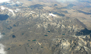
The Cordillera Quimsa Cruz is a mountain range in the La Paz Department in Bolivia situated south east of Lake Titicaca and north of Lake Uru Uru, measuring about 35-40 km in length and 12 km at its widest point. It is the continuation of the Cordillera Real of Bolivia extending in a north to south-eastern direction from Asiento pass south of Illimani to Tres Cruces pass.

Kimsa Chata, also spelled Kimsachata, is a 4,735-metre-high (15,535 ft) mountain in the Andes in Bolivia. It is located in the Chilla-Kimsa Chata mountain range south-east of Wiñaymarka Lake, the southern part of Lake Titicaca. It lies in the La Paz Department, Ingavi Province, Tiwanaku Municipality, about 15 km south of the archaeological site of Tiwanaku and the village of the same name. Kimsa Chata is situated between the mountains Nasa Puqi in the north and Chuqi Ch'iwani in the south.
Kimsa Chata is a 5,245-metre-high (17,208 ft) mountain in the Andes of Bolivia. It is located in the Oruro Department, Sabaya Province, Sabaya Municipality, Negrillos Canton. It lies south-east of the mountain Qillwiri, east of Lliscaya, north-east of Taypi Qullu and north-west of the Laram Pukara, near the border with Chile.
The Chilla-Kimsa Chata mountain range is situated in Bolivia south east of Wiñaymarka Lake, the southern part of Lake Titicaca, in the La Paz Department, Ingavi Province. The range is named after one of highest mountains, the Kimsa Chata complex rising up to 4,735 metres (15,535 ft) about 15 km south of Tiwanaku.
Kimsa Kunturiri is a group of three mountains in the Andes of Bolivia in the Potosí Department at the border of Tomás Frías Province and Cornelio Saavedra Province. The peaks are about 5,020 m, 4,980 m and 4,960 m high. The Kimsa Kunturiri group is situated in the Khari Khari mountain range east of Potosí. It lies north of the Kimsa Waylla group, between the lakes Jatun Wak'ani (Jatun Huacani) and Juch'uy Wak'ani (Juchuy Huacani) in the west and the Jatun Tiyu Lakes in the east.
Kimsa Chata is a group of three mountains in the Andes of Bolivia. It is located in the Oruro Department, Sajama Province, in the north of the Turco Municipality. It is situated north-east of the mountains Yaritani and Wankarani. The northern peak is 4,809 metres (15,778 ft) high. The two other peaks of the groups lie south-east of it.
Kimsa Willk'i is a 5,032-metre-high (16,509 ft) mountain in the Bolivian Andes. It is located in the La Paz Department, Inquisivi Province, in the south of the Quime Municipality. Kimsa Willk'i is situated south-east of the mountain Wisk'achani. The lakes Muyu Quta (Muyu Khota) and Wiska Quta (Wisca Khota) lie at its feet, north-west of it.
Ch'utu Wankarani is a 4,475-metre-high (14,682 ft) mountain in the Chilla-Kimsa Chata mountain range in the Andes of Bolivia. It is located in the La Paz Department, Ingavi Province, Jesús de Machaca Municipality, northeast of Ch'ama (Chama). Ch'utu Wankarani lies northeast of Imill Wawani and Apachita and southeast of Jisk'a Sallalla and Wisk'achani. The Wila Jaqhi Jawira originates near Ch'utu Wankarani. It flows to the northeast.
Wanq'uni is a 4,599-metre-high (15,089 ft) mountain in the Chilla-Kimsa Chata mountain range in the Andes of Bolivia. It lies in the La Paz Department, Ingavi Province, at the border of the Guaqui Municipality and the Jesús de Machaca Municipality. Wanq'uni is situated northeast of Tanka Tankani and southeast of Quta Willk'i.

Pacha Qullu or Kimsa Misa is a 4,702-metre-high (15,427 ft) mountain in the Andes of Bolivia. It is located in the Oruro Department, Litoral Province, Huachacalla Municipality, west of Huachacalla (Wachaqalla). Pacha Qullu lies northwest of Inka Qhamachu. The plain at 18°42′44.86″S68°34′25.21″W northwest of Pacha Qullu is named Kimsa Misa Pampa (Quimsa Misa Pampa).
Chuqi Warani is a 5,388-metre-high (17,677 ft) mountain in Bolivia. It is located in the Potosí Department, Antonio Quijarro Province, Tomave Municipality. It lies southwest of the Jatun Mundo Quri Warani volcano. In the map of the Bolivian Instituto Geográfico Militar the term Chaupi Mundo is added under Cerro Choquehuarani. This may be an alternate name or a supplement.
The Ch'alla Jawira is a river in the La Paz Department in Bolivia. It is a left tributary of the Tiwanaku River which empties into Wiñaymarka Lake, the southern part of Lake Titicaca.
Janq'u Apachita is a 4,570-metre-high (14,990 ft) mountain in the southern part of the Chilla-Kimsa Chata mountain range in the Andes of Bolivia. It is located in the La Paz Department, Pacajes Province, Waldo Ballivián Municipality. Janq'u Apachita lies northeast of Wila Qullu.
Kimsa Phujru is a mountain in the western extensions of the Cordillera Real in the Andes of Bolivia which reaches a height of approximately 4,220 m (13,850 ft). It is located in the La Paz Department, Los Andes Province, Batallas Municipality. Kimsa Phujru lies at the Pura Purani River, an affluent of the Qiqa Jawira.
Kimsa Misa is a mountain in the Andes of Bolivia which reaches a height of approximately 4,800 m (15,700 ft). It is located in the Oruro Department, Sajama Province, at the border of the municipalities of Curahuara de Carangas and Turco. Kimsa Misa lies north of Wayna Potosí.
Kimsa Llallawa is a 4,382 m (14,377 ft) mountain in the Bolivian Andes. It is located in the La Paz Department, Inquisivi Province, Colquiri Municipality, east of Colquiri.
Kimsa Q'awa is a 4,543 m (14,905 ft) mountain in the Bolivian Andes. It is located in the La Paz Department, Inquisivi Province, Colquiri Municipality, southeast of Colquiri.
Kimsa Qullu is a 4,624-metre-high (15,171 ft) mountain in the Andes of Bolivia. It is located in the Oruro Department, Nor Carangas Province.


