
Launceston is a city in the north of Tasmania, Australia, at the confluence of the North Esk and South Esk rivers where they become the Tamar River (kanamaluka). As of 2021, the Launceston urban area has a population of 90,953. Launceston is the second most populous city in Tasmania after the state capital, Hobart. As of 2020, Launceston is the 18th largest city in Australia. Launceston is the fifth-largest inland city and the ninth-largest non-capital city in Australia. Launceston is regarded as the most livable regional city, and was one of the most popular regional cities to move to in Australia from 2020 to 2021. Launceston was named Australian Town of the Year in 2022.
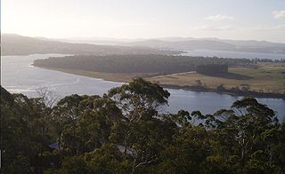
The Tamar River, officially kanamaluka / River Tamar, is a 70-kilometre (43-mile) estuary located in northern Tasmania, Australia. Despite being called a river, the waterway is a brackish and tidal estuary over its entire length.

Longford is a town in the northern midlands of Tasmania, Australia. It lies 145 m above sea level at the convergence of the Macquarie River and the South Esk River, 21 km south of Launceston and a 15-minute drive from the airport. It is just south of the Illawarra Road, a road connecting the Bass and Midland Highways. It has a population of 3,863 and is part of the Northern Midlands Council area. The region is predominantly agricultural, noted for wool, dairy produce and stock breeding.

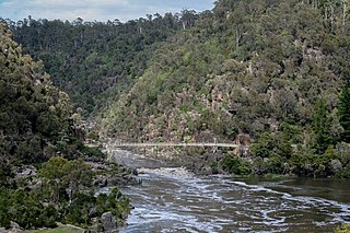
The Cataract Gorge is a river gorge in Launceston, Tasmania, Australia, approximately 1.5 km from the city centre. It is one of the region's premier tourist attractions with a Cataract Gorge boat trip leaving from Home Point Parade. It is found at the lower section of the South Esk River.
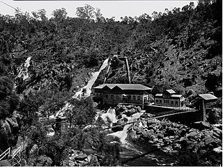
Duck Reach Power Station was the first publicly owned hydro-electric plant in the Southern Hemisphere, and provided the Tasmanian city of Launceston with hydro-electric power from its construction in 1895 to its closure in 1955.

The Bridgewater Bridge is a combined road and rail bridge that carries the Midland Highway and South Railway Line across the Derwent River in Hobart, Tasmania, Australia. This steel truss vertical lift bridge and specially-built causeway connect the Hobart suburbs of Bridgewater and Granton. The bridge was completed in 1946 and accommodates a two-lane highway, a single track railway and a grade-separated footpath.
The South Esk River, the longest river in Tasmania, is a major perennial river located in the northern region of Tasmania, Australia.

The North Esk River is a major perennial river located in the northern region of Tasmania, Australia.

Evandale is an historic town in northern Tasmania, Australia. It sits on the banks of the South Esk River, 18 km south of Launceston. Named after early colonial explorer and Surveyor-General George Evans, the town is famous for its late-Georgian and early-Victorian buildings with relatively untouched streetscape, a popular Sunday market and as a host to the annual national Penny Farthing bicycle Championships. At the 2016 census, Evandale had a population of 1,345.
The Arthur Highway (A9) is a Tasmanian highway which runs from Sorell in the near south to Port Arthur in the far south-east.
The Western Line, previously known as the Launceston and Western Line, is a 223 km freight rail corridor that runs from Western Junction to Wiltshire in Tasmania, Australia.

Trevallyn is a residential locality in the local government areas (LGAs) of Launceston (25%) and West Tamar (75%) in the Launceston LGA region of Tasmania. The locality is about 3 kilometres (1.9 mi) west of the city of Launceston. The 2016 census recorded a population of 4562 for the state suburb of Trevallyn. It is a suburb of Launceston.
Invermay is a residential locality in the local government area (LGA) of Launceston in the Launceston LGA region of Tasmania. The locality is about 3 kilometres (1.9 mi) north of the town of Launceston. The 2021 census recorded a population of 3,498 for the state suburb of Invermay. It is a suburb of Launceston, which contains the minor suburb of Inveresk, it is located on the eastern side of the Tamar River and the northern side of the North Esk River, the suburb is most notable as being home to York Park.

Campbell Town is a town in Tasmania, Australia, on the Midland Highway. At the 2021 census, the town had a population of 823.

The Red Bridge in Tasmania crosses the Elizabeth River at Campbell Town. Built in 1838 using penal labour, it is the oldest surviving brick arch bridge in Australia, as well as the oldest bridge anywhere on the National Highway. The bridge contains three arch spans of 7.6 m (25 ft) each and holds two lanes of traffic as well as pedestrian walkways. It lies on the Midland Highway, roughly halfway between Hobart and Launceston, carrying over two million vehicles per year.

Hadspen is a town on the South Esk River in the north of Tasmania, Australia, 8 kilometres (5.0 mi) south west of Launceston. Hadspen has few commercial establishments and is primarily a residential suburb of nearby Launceston. Most of the town's buildings are residential, and relatively recent. The town's population of just over 2000 has grown rapidly from only a few hundred in the 1960s, and there are development plans that call for its doubling.
West Launceston is a residential locality in the local government area (LGA) of Launceston in the Launceston LGA region of Tasmania. The locality is about 3 kilometres (1.9 mi) south-west of the town of Launceston. The 2016 census recorded a population of 4212 for the state suburb of West Launceston. The suburb is part of the Launceston CBD and is also near Cataract Gorge.

Conara is a rural locality in the local government area (LGA) of Northern Midlands in the Central LGA region of Tasmania. The locality is about 50 kilometres (31 mi) south-east of the town of Longford. The 2016 census recorded a population of 130 for the state suburb of Conara.

The Longford Railway Bridge is a railway bridge spanning the South Esk River, in Longford, Tasmania. The Western Railway Line travels over the bridge, enabling freight movement to/from the major Container ports of Burnie and Devonport and the rest of the state. In 1978, it was listed in the now-defunct Register of the National Estate.

The Launceston tramway network served the city of Launceston, Tasmania in Australia from 1911 until 1952.

