King Salmon River (Egegik River tributary)

Last updated
King Salmon River
Relief map of USA Alaska.png
Red pog.svg
Location of the mouth of the King Salmon River in Alaska
Location
Country United States
State Alaska
Borough Lake and Peninsula
Physical characteristics
Sourceconfluence of Contact and Takayofo creeks
 - location Katmai National Park and Preserve
 - coordinates 58°09′46″N156°00′23″W / 58.16278°N 156.00639°W / 58.16278; -156.00639 [1]
 - elevation482 ft (147 m) [2]
River mouth Egegik River
 - location37 miles (60 km) southwest of Naknek, Alaska Peninsula
 - coordinates 58°13′26″N157°19′44″W / 58.22389°N 157.32889°W / 58.22389; -157.32889 Coordinates: 58°13′26″N157°19′44″W / 58.22389°N 157.32889°W / 58.22389; -157.32889 [1]
 - elevation0 ft (0 m) [1]
Length60 mi (97 km) [1]

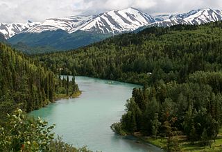
The King Salmon River is a 60-mile (97 km) tributary of the Egegik River on the western slope of the Alaska Peninsula in southwest Alaska. [1] Formed by the confluence of Contact and Takayofo creeks along the southwest border of Katmai National Park and Preserve, it flows west-northwest to meet the larger river about 2 miles (3 km) east of the village of Egegik. [3]

Egegik River river in Alaska, United States

The Egegik River is a waterway in the U.S. state of Alaska. A biological survey was conducted at the base of the Alaska Peninsula in 1902 by Wilfred Hudson Osgood, which included the Egegik River.

Alaska Peninsula peninsula extending about 800 km (497 mi) to the southwest from the mainland of Alaska and ending in the Aleutian Islands

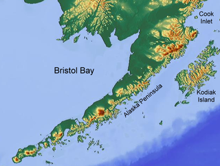
The Alaska Peninsula is a peninsula extending about 800 km (497 mi) to the southwest from the mainland of Alaska and ending in the Aleutian Islands. The peninsula separates the Pacific Ocean from Bristol Bay, an arm of the Bering Sea.

Katmai National Park and Preserve United States National Park and Preserve in southern Alaska

Katmai National Park and Preserve is an American national park and preserve in southern Alaska, notable for the Valley of Ten Thousand Smokes and for its brown bears. The park and preserve encompass 4,093,077 acres, which is between the sizes of Connecticut and New Jersey. Most of the national park—more than 3,922,000 acres —is a designated wilderness area where all hunting is banned. The park is named after Mount Katmai, its centerpiece stratovolcano. The park is located on the Alaska Peninsula, across from Kodiak Island, with headquarters in nearby King Salmon, about 290 miles (470 km) southwest of Anchorage. The area was first designated a national monument in 1918 to protect the area around the major 1912 volcanic eruption of Novarupta, which formed the Valley of Ten Thousand Smokes, a 40-square-mile (100 km2), 100-to-700-foot-deep pyroclastic flow. The park includes as many as 18 individual volcanoes, seven of which have been active since 1900.

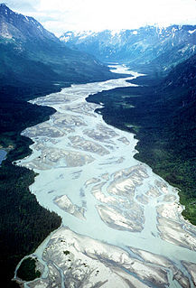
A relatively straight and braided river, [3] it descends from an elevation of about 500 feet (152 m) to sea level. [1] Being quite shallow, it is not navigable beyond its lower reaches. Although game fish on the river include king, chum, and silver salmon, the main species are rainbow trout, Arctic grayling, and char. [4]

Game fish fish hunted for sport or food

Game fish are fish pursued by recreational anglers. They can be freshwater or saltwater fish. Game fish can be eaten after being caught. Some game fish are also targeted commercially, particularly salmon.

Chum salmon species of fish

The chum salmon is a species of anadromous fish in the salmon family. It is a Pacific salmon, and may also be known as dog salmon or keta salmon, and is often marketed under the name silverbrite salmon. The name chum salmon comes from the Chinook Jargon term tzum, meaning "spotted" or "marked", while keta in the scientific name comes from the Evenki language of Eastern Siberia via Russian.

Rainbow trout species of trout

The rainbow trout is a trout and species of salmonid native to cold-water tributaries of the Pacific Ocean in Asia and North America. The steelhead is an anadromous (sea-run) form of the coastal rainbow trout(O. m. irideus) or Columbia River redband trout (O. m. gairdneri) that usually returns to fresh water to spawn after living two to three years in the ocean. Freshwater forms that have been introduced into the Great Lakes and migrate into tributaries to spawn are also called steelhead.

See also

Related Research Articles

Lake and Peninsula Borough, Alaska Borough in the United States

Lake and Peninsula Borough is a borough in the state of Alaska. As of the 2010 census, the population was 1,631. The borough seat of King Salmon is located in neighboring Bristol Bay Borough, although is not the seat of that borough. The most populous community in the borough is the city of Newhalen. With an average of 0.0296 inhabitants/km2, the Lake and Peninsula Borough is the second least densely populated organized county-equivalent in the United States; only the unorganized Yukon-Koyukuk Census Area has a lower density.

Copper River (Alaska) river in the United States of America

The Copper River or Ahtna River, Ahtna Athabascan ‘Atna’tuu, "river of the Ahtnas", Tlingit Eeḵhéeni, "river of copper", is a 290-mile (470 km) river in south-central Alaska in the United States. It drains a large region of the Wrangell Mountains and Chugach Mountains into the Gulf of Alaska. It is known for its extensive delta ecosystem, as well as for its prolific runs of wild salmon, which are among the most highly prized stocks in the world. The river is the tenth largest in the United States, as ranked by average discharge volume at its mouth.

Nenana River river in the United States of America

The Nenana River is a tributary of the Tanana River, approximately 140 miles (230 km) long, in central Alaska in the United States. It drains an area on the north slope of the Alaska Range on the south edge of the Tanana Valley southwest of Fairbanks.

Chena River river in Alaska

The Chena River is a 100-mile (160 km) tributary of the Tanana River in the Interior region of the U.S. state of Alaska. It flows generally west from the White Mountains to the Tanana River near the city of Fairbanks, which is built on both sides of the river. The Tanana empties into the 2,300-mile (3,700 km) long Yukon River.

Kenai River river in the United States of America

The Kenai River called Kahtnu in the Dena'ina language, is the longest river in the Kenai Peninsula of south central Alaska. It runs 82 miles (132 km) westward from Kenai Lake in the Kenai Mountains, through the Kenai National Wildlife Refuge and Skilak Lake to its outlet into the Cook Inlet of the Pacific Ocean near Kenai and Soldotna.

Bristol Bay easternmost arm of the Bering Sea, at 57° to 59° North 157° to 162° West in Southwest Alaska; 400 km long, 290 km, wide at its mouth; rivers flowing into it include the Cinder, Egegik, Igushik, Kvichak, Meshik, Nushagak, Naknek, Togiak, and Ugashik

Bristol Bay is the eastern-most arm of the Bering Sea, at 57° to 59° North 157° to 162° West in Southwest Alaska. Bristol Bay is 400 km (250 mi) long and 290 km, (180 mi) wide at its mouth. A number of rivers flow into the bay, including the Cinder, Egegik, Igushik, Kvichak, Meshik, Nushagak, Naknek, Togiak, and Ugashik.

Iliamna Lake lake in southwest Alaska

Iliamna Lake or Lake Iliamna is a lake in southwest Alaska, at the north end of the Alaska Peninsula, between Kvichak Bay and Cook Inlet, about 100 miles (160 km) west of Seldovia, Alaska.

Chilikadrotna River river in the United States of America

The Chilikadrotna River is a 55-mile (89 km) tributary of the Mulchatna River in the U.S. state of Alaska. It begins in Lake Clark National Park and Preserve in northern Lake and Peninsula Borough and flows westward into the larger river 46 miles (74 km) northwest of Nondalton.

Mulchatna River watercourse

The Mulchatna River is a 160-mile (260 km) tributary of the Nushagak River in the U.S. state of Alaska. Beginning at Turquoise Lake, it flows generally southwest to meet the larger river 65 miles (105 km) northeast of Dillingham. The Mulchatna's mouth is slightly south (downstream) of the village of Koliganek on the Nushagak, which continues southwest to Nushagak Bay, an arm of Bristol Bay.

Tlikakila River river in the United States of America

The Tlikakila River is a stream, 51 miles (82 km) long, in the U.S. state of Alaska. The river, lying entirely within Lake Clark National Park, flows southwest from Summit Lake in the Chigmit Mountains of the Aleutian Range to Lake Clark.

Dago Creek

Dago Creek is a stream, 50 miles (80 km) long, on the Alaska Peninsula in the U.S. state of Alaska. Beginning in a small lake 16 miles (26 km) southeast of Egegik, it meanders southwest across the flats to enter Ugashik Bay 3 miles (5 km) southeast of Smoky Point.

Southwest Alaska

Southwest Alaska is a region of the U.S. state of Alaska. The area is not exactly defined by any governmental administrative region(s); nor does it always have a clear geographic boundary.

King Salmon River (Ugashik River tributary) river in Alaska

The King Salmon River is a 35-mile (56 km) tributary of the Ugashik River in the U.S. state of Alaska. Beginning at Mother Goose Lake in the Aleutian Range, it flows northwest to meet the larger river near the upper reaches of Ugashik Bay. The lake and the upper course of the King Salmon lie within the Alaska Peninsula National Wildlife Refuge. The river's gravel bottom and braided channels are ideal for the many king salmon that spawn in its waters, but they limit navigation to small skiff.

Salmon River (Clackamas County, Oregon) river in Oregons Cascade Range

The Salmon River is a 33.5-mile (53.9 km) river in the Cascade Range in the U.S. state of Oregon that drains part of southwestern Mount Hood. The entire length of the river is a protected National Wild and Scenic River. Several portions are in protected wilderness. It is affluent to the Sandy River, a tributary of the Columbia River.

Salcha River river in the United States of America

The Salcha River is a 125-mile (201 km) tributary of the Tanana River in the U.S. state of Alaska. Rising in the eastern part of the Fairbanks North Star Borough east of Fort Wainwright, it flows generally west-southwest to meet the larger river at Aurora Lodge, 33 miles (53 km) southeast of Fairbanks.

King Salmon River (Nushagak River tributary) river in the United States of America

The King Salmon River is a 45-mile (72 km) tributary of the Nushagak River in southwest Alaska, United States. It flows eastward from headwaters 60°17′06″N158°28′33″W at a small unnamed lake in the Taylor Mountains to its confluence with the larger river about 220 miles (354 km) north of Nushagak Bay.

Egegik Bay is a bay located just 69.1 miles from Dillingham in Alaska and the northeastern arm of the Bristol Bay. The Egegik village is located on a high bluff along the southern shore of the Egegik River at the upper extent of Egegik Bay. The nearest places to Egegik Bay are Coffee Point, Coffee Point, Goose Point, Egegik Airport, and Bartletts Airport.

References

  1. 1 2 3 4 5 6 "King Salmon River". Geographic Names Information System. United States Geological Survey. March 31, 1981. Retrieved November 30, 2013.
  2. Derived by entering source coordinates in Google Earth.
  3. 1 2 Alaska Atlas & Gazetteer (7th ed.). Yarmouth, Maine: DeLorme. 2010. pp. 49&ndash, 50. ISBN   978-0-89933-289-5.
  4. Limeres, Rene; Pedersen, Gunnar; et al. (2005). Alaska Fishing: The Ultimate Angler's Guide (3rd ed.). Roseville, California: Publishers Design Group. p. 234. ISBN   1-929170-11-4.