
Peggy's Cove is a small rural community located on the eastern shore of St. Margarets Bay in the Halifax Regional Municipality, which is the site of Peggys Cove Lighthouse.

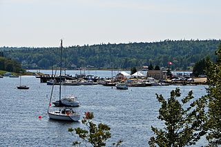
Riverport is a village in Lunenburg County, Nova Scotia, Canada. The harbour of Ritcey Cove is free from shoals and safe from every wind, considered one of the finest in North America. Riverport is a five-minute drive to several public beaches including Hirtle's Beach, Kingsburg Beach, Oxner Beach, Rose Bay Beach and Spindler Beach.

Lower Sackville is a community within the urban area of Halifax Regional Municipality, in Nova Scotia, Canada.
The Aspotogan Peninsula is a peninsula in the eastern part of Lunenburg County, Nova Scotia, separating St. Margarets Bay in the east from Mahone Bay in the west. The peninsula was originally settled by second generation French immigrants on the east side and by second generation German immigrants on the west side. Traditionally fishing was a major industry for communities throughout the peninsula, however other primary industries such as farming and forestry were historically important as well. Shipping and shipbuilding were secondary and tertiary industries that also came into prominence during the 19th and early 20th centuries.

The Eastern Shore is a region of the Canadian province of Nova Scotia. It is the Atlantic coast running northeast from Halifax Harbour to the eastern end of the peninsula at the Strait of Canso.
Grande-Anse is a former village in Gloucester County, New Brunswick, Canada. It held village status prior to 2023 and is now part of the town of Rivière-du-Nord.
The Lighthouse Route is a scenic roadway in the Canadian province of Nova Scotia. It follows the province's South Shore for 585 km (364 mi) from Halifax to Yarmouth.

Route 332 is a collector road in the Canadian province of Nova Scotia. It is located in Lunenburg County, connecting Bridgewater at Trunk 3 with Lunenburg at Trunk 3. It is commonly referred to residences as Riverport Road as the village appears on all major road signage in the county.
Hubbards is an unincorporated Canadian rural community on the South Shore of Nova Scotia.

Nova Scotia is a province located in Eastern Canada fronting the Atlantic Ocean. One of the Maritime Provinces, Nova Scotia's geography is complex, despite its relatively small size in comparison to other Canadian provinces.
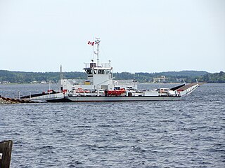
LaHave is a Canadian community in Lunenburg County, Nova Scotia. The community is located across the river from Riverport and approximately 15 kilometres from the town of Bridgewater. Once the capital of Acadia, it is located on Highway 331 at the mouth of the 97 km long LaHave River.
Mill Village is a Canadian rural community in the Region of Queens Municipality, Nova Scotia. It developed in relation to the lumber industry. Located inland from the Atlantic coast, Mill Village was the site of Canada's first satellite earth station constructed in the 1960s.

North Mountain is a narrow southwest-northeast trending volcanic ridge on the mainland portion of southwestern Nova Scotia, stretching from Brier Island to Cape Split. It forms the northern edge of the Annapolis Valley along the shore of the Bay of Fundy. Together with South Mountain, the two ranges form the Annapolis Highlands region.

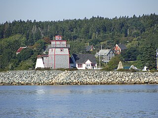
Rose Bay is a community in the Canadian province of Nova Scotia, in Lunenburg County.
Indian Path is part of the Riverport District, a community in the Canadian province of Nova Scotia, in Lunenburg County.

The Foreign Protestants were a group of non-British Protestant immigrants to Nova Scotia, primarily originating from France and Germany. They largely settled in Halifax at Gottingen Street and Dutch Village Road as well as Lunenburg.
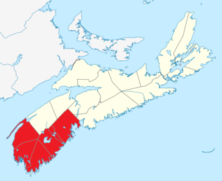
Southern Nova Scotia or the South Shore is a region of Nova Scotia, Canada. The area has no formal identity and is variously defined by geographic, county and other political boundaries. Statistics Canada, defines Southern Nova Scotia as an economic region, composed of Lunenburg County, Queens County, Shelburne County, Yarmouth County, and Digby County. According to Statistics Canada, the region had the highest decrease of population in Canada from 2009 to 2010, with a population decrease of 10.2 residents per thousand. The region also has the second-highest median age in Canada at 47.1 years old.

Division No. 1, Subdivision G is an unorganized subdivision on the Avalon Peninsula in Newfoundland and Labrador, Canada. It is in Division 1 and contains the unincorporated communities of Baccalieu Island, Besom Cove, Bradley's Cove, Burnt Point, Caplin Cove, Daniel's Cove, Grates Cove, Gull Island, Job's Cove, Kingston, Long Beach, Lower Island Cove, Low Point, Northern Bay, Ochre Pit Cove, Red Head Cove, Riverhead, Smooth Cove and Western Bay.


