Kirkwood, Ohio

Last updated

Location of Kirkwood, Ohio OHMap-doton-Kirkwood.png
Location of Kirkwood, Ohio

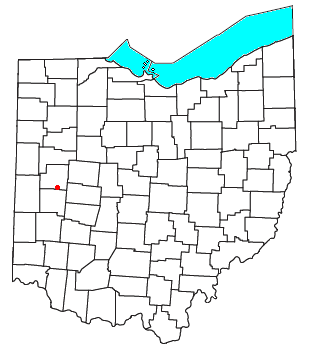
Kirkwood is a rural unincorporated community located at the intersection of Kirkwood and River Roads in southwestern Orange Township, Shelby County, Ohio, United States. [1]

Originally named Pontiac before the name change, Kirkwood is located halfway between Sidney to the north and Piqua to the south in neighboring Miami County. The original Dayton and Michigan Railroad, later B&O, Chessie System, and now CSX Transportation runs through Kirkwood. The rural community is visible from Interstate 75 as an overpass over Kirkwood Road, although no exit for Kirkwood exits.

Kirkwood was originally called Pontiac, and under the latter name was platted in 1868. [2] A post office called Kirkwood was established in 1866, and remained in operation until 1913. [3] The present name honors D. Kirkwood Gillespie, the proprietor of a local grain elevator. [4]

Related Research Articles

<span class="mw-page-title-main">Shelby Charter Township, Michigan</span> Charter township in Michigan, United States

Shelby Charter Township, officially the Charter Township of Shelby, is a charter township located in Macomb County in the U.S. state of Michigan. The township is an affluent northern suburb of Detroit. As of the 2020 census, the population was 79,408, up from 73,804 in 2010. Shelby Charter Township is one of the fastest-growing communities in Metro Detroit.

<span class="mw-page-title-main">Mount Jefferson, Ohio</span> Unincorporated community in Ohio, U.S.

Mount Jefferson is an unincorporated community in Loramie Township, Shelby County, Ohio, United States. It lies along State Route 66 south of Houston. At 961 feet (293 m) above sea level, it is not on a summit, but is located on the south slope of the valley formed by Ninemile Creek, a tributary of Loramie Creek.

<span class="mw-page-title-main">Houston, Ohio</span> Unincorporated community in Ohio, U.S.

Houston is an unincorporated community in northern Loramie Township, Shelby County, Ohio, United States. It has a post office, a dollar general, and a grain elevator.

<span class="mw-page-title-main">Phoneton, Ohio</span> Unincorporated community in Miami County, Ohio, United States

Phoneton is an unincorporated community in southwestern Bethel Township, Miami County, Ohio, United States, that is located at the junction of the National Road and Old Troy Pike in southwestern Bethel Township, Miami County, Ohio, United States. It is part of the Dayton Metropolitan Statistical Area.

<span class="mw-page-title-main">Maplewood, Ohio</span> Unincorporated community in Ohio, United States

Maplewood is an unincorporated community in northern Salem Township, Shelby County, Ohio, United States. It has a post office with the ZIP code 45340. It lies along State Route 65.

<span class="mw-page-title-main">Pemberton, Ohio</span> Unincorporated community in Ohio, U.S.

Pemberton is an unincorporated community in eastern Perry Township, Shelby County, Ohio, United States. It has a post office with the ZIP code 45353.

<span class="mw-page-title-main">Swanders, Ohio</span> Unincorporated community in Ohio, U.S.

Swanders is a rural unincorporated community located on Fort Loramie-Swanders Road in Franklin Township, Shelby County, Ohio, United States. It lies midway between the village of Anna and the city of Sidney.

<span class="mw-page-title-main">Tawawa, Ohio</span> Unincorporated community in Ohio, U.S.

Tawawa is an unincorporated community in northeastern Green Township, Shelby County, Ohio, United States. It lies along State Route 29 less than one mile away from the Champaign County border. Mosquito Creek, a tributary of the Great Miami River, flows northwestward along the southern edge of Tawawa. The community lies 8 miles southeast of the city of Sidney, the county seat of Shelby County.

<span class="mw-page-title-main">Montra, Ohio</span> Unincorporated community in Ohio, U.S.

Montra is an unincorporated community in Jackson Township, Shelby County, Ohio, United States. Established in the middle of the nineteenth century, the small community is prominent because of a landmark church, Emanuel Lutheran Church of Montra.

<span class="mw-page-title-main">St. Patrick, Ohio</span> Unincorporated community in Ohio, United States

St. Patrick is an unincorporated community in northwestern Turtle Creek Township, Shelby County, Ohio, United States. It lies at the intersection of Hoying and Wright-Puthoff Roads, northwest of the city of Sidney, the county seat of Shelby County. Its elevation is 971 feet (296 m) and it is located at 40°22′15″N84°17′15″W.

Uno is an unincorporated community in northwestern Turtle Creek Township in Shelby County, in the U.S. state of Ohio.

Oran is an unincorporated community in Shelby County, in the U.S. state of Ohio.

Plattsville is an unincorporated community in Shelby County, in the U.S. state of Ohio.

Ballou is an unincorporated community in Shelby County, in the U.S. state of Ohio.

Pasco is an unincorporated community in Shelby County, in the U.S. state of Ohio.

Hardin is an unincorporated community in Shelby County, in the U.S. state of Ohio.

Rumley is an unincorporated community in Shelby County, in the U.S. state of Ohio.

<span class="mw-page-title-main">Newbern, Ohio</span> Unincorporated community in Ohio, U.S.

Newbern is an unincorporated community in Shelby County, in the U.S. state of Ohio.

Campbellsport is an unincorporated community in Portage County, in the U.S. state of Ohio. It is located southeast of Ravenna around the intersection of Industry Road and Ohio State Route 14, where the townships of Ravenna, Charlestown, Rootstown, and Edinburg meet. Much of the area is now occupied by the adjacent West Branch State Park and Michael J. Kirwan Reservoir, which were created in 1965.

<span class="mw-page-title-main">Hyatts, Ohio</span> Unincorporated community in Ohio, U.S.

Hyatts is an unincorporated community in Delaware County, in the U.S. state of Ohio.

References

  1. U.S. Geological Survey Geographic Names Information System: Kirkwood, Ohio
  2. History of Shelby County, Ohio: With Illustrations and Biographical Sketches of Some of Its Prominent Men and Pioneers. Sutton. 1883. p. 185.
  3. "Shelby County". Jim Forte Postal History. Retrieved December 24, 2015.
  4. Overman, William Daniel (1958). Ohio Town Names. Akron, OH: Atlantic Press. p. 71.

40°12′58″N84°11′50″W / 40.21611°N 84.19722°W / 40.21611; -84.19722