Jackson Center, Ohio

Last updated

Jackson Center, Ohio
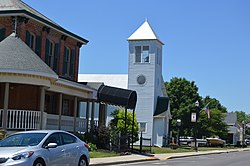
West Pike, Jackson Center.jpg
OHMap-doton-Jackson Center.png
Location of Jackson Center, Ohio
Map of Shelby County Ohio Highlighting Jackson Center Village.png
Location of Jackson Center in Shelby County
Coordinates: 40°26′24″N84°2′22″W / 40.44000°N 84.03944°W / 40.44000; -84.03944
Country United States
State Ohio
County Shelby
Government
   Mayor Scott Klopfenstein
Area
[1]
  Total1.73 sq mi (4.48 km2)
  Land1.72 sq mi (4.46 km2)
  Water0.01 sq mi (0.02 km2)
Elevation
[2]
1,025 ft (312 m)
Population
 (2020)
  Total1,441
  Density837.30/sq mi (323.27/km2)
Time zone UTC-5 (Eastern (EST))
  Summer (DST) UTC-4 (EDT)
ZIP code
45334
Area code(s) 937, 326
FIPS code 39-38220 [3]
GNIS feature ID1065697 [2]
Website http://www.jacksoncenter.com/

Jackson Center is a village in Shelby County, Ohio, United States. The population was 1,441 at the 2020 census.

Contents

Jackson Center has been the home of the popular Airstream travel trailers and motor homes since 1952.

Jackson Center is accessible from Interstate 75 at Exit 102, north of the Shelby County seat of Sidney. State Route 274 links I-75 to Jackson Center (the exit is signed "Jackson Center/New Bremen").

History

Jackson Center was platted in 1835. [4] A post office called Jackson Center has been in operation since 1858. [5]

Geography

Jackson Center is located at 40°26′24″N84°2′22″W / 40.44000°N 84.03944°W / 40.44000; -84.03944 (40.440067, -84.039414). [6]

According to the United States Census Bureau, the village has a total area of 1.69 square miles (4.38 km2), of which 1.68 square miles (4.35 km2) is land and 0.01 square miles (0.03 km2) is water. [7]

Demographics

Historical population
CensusPop.Note
1870 60
1900 644
1910 6856.4%
1920 573−16.4%
1930 526−8.2%
1940 5667.6%
1950 69823.3%
1960 98040.4%
1970 1,11914.2%
1980 1,31017.1%
1990 1,3986.7%
2000 1,369−2.1%
2010 1,4626.8%
2020 1,441−1.4%
U.S. Decennial Census [8]

2000 census

As of the census [9] of 2000, there were 1,369 people, 541 households, and 394 families living in the village. The population density was 1,088.9 inhabitants per square mile (420.4/km2). There were 584 housing units at an average density of 464.5 per square mile (179.3/km2). The racial makeup of the village was 99.12% White, 0.51% African American, 0.22% Native American, 0.15% from other races. Hispanic or Latino of any race were 0.44% of the population.

There were 541 households, out of which 36.8% had children under the age of 18 living with them, 58.8% were married couples living together, 10.2% had a female householder with no husband present, and 27.0% were non-families. 23.7% of all households were made up of individuals, and 12.6% had someone living alone who was 65 years of age or older. The average household size was 2.53 and the average family size was 2.97.

In the village, the population was spread out, with 29.2% under the age of 18, 8.8% from 18 to 24, 28.3% from 25 to 44, 20.2% from 45 to 64, and 13.4% who were 65 years of age or older. The median age was 33 years. For every 100 females there were 94.5 males. For every 100 females age 18 and over, there were 89.3 males.

The median income for a household in the village was $40,650, and the median income for a family was $47,240. Males had a median income of $35,313 versus $23,654 for females. The per capita income for the village was $17,755. About 6.2% of families and 7.6% of the population were below the poverty line, including 12.7% of those under age 18 and 6.7% of those age 65 or over.

2010 census

As of the census [9] of 2010, there were 1,462 people, 576 households, and 404 families living in the village. The population density was 870.2 inhabitants per square mile (336.0/km2). There were 644 housing units at an average density of 383.3 per square mile (148.0/km2). The racial makeup of the village was 98.1% White, 0.1% Asian, 0.6% from other races, and 1.2% from two or more races. Hispanic or Latino of any race were 1.7% of the population.

There were 576 households, of which 36.3% had children under the age of 18 living with them, 53.0% were married couples living together, 10.2% had a female householder with no husband present, 6.9% had a male householder with no wife present, and 29.9% were non-families. 26.9% of all households were made up of individuals, and 10.4% had someone living alone who was 65 years of age or older. The average household size was 2.54 and the average family size was 3.05.

The median age in the village was 35.7 years. 29.7% of residents were under the age of 18; 5.9% were between the ages of 18 and 24; 27.9% were from 25 to 44; 23% were from 45 to 64; and 13.6% were 65 years of age or older. The gender makeup of the village was 49.9% male and 50.1% female.
Education

Jackson Center Local School District operates one large K-12 school building which includes the Jackson Center High School. [10]

Jackson Center has a public library, a branch of Shelby County Libraries. [11]

Arts and culture

Jackson Center is the location of the Elder Theatre, the last indoor movie theater serving Shelby County. (The Sidney Theater in Sidney, Ohio is now a local live performance venue.) The Elder, in business since 1942, held a fundraiser to convert to digital projection equipment as 35mm film is being phased out. A fundraiser took place starting on May 20, 2013, and met the $28,000 goal before midnight on July 2, 2013.[ citation needed ]

Related Research Articles

<span class="mw-page-title-main">Concord, Michigan</span> Village in Michigan, United States

Concord is a village in Jackson County in the U.S. state of Michigan. The population was 1,050 at the 2010 census. The village is within Concord Township.

<span class="mw-page-title-main">Shelby County, Iowa</span> County in Iowa, United States

Shelby County is a county located in the U.S. state of Iowa. As of the 2020 census, the population was 11,746. The county seat is Harlan. Its name is in honor of Isaac Shelby, the first Governor of Kentucky.

<span class="mw-page-title-main">Calera, Alabama</span> City in Alabama, United States

Calera is a city in Shelby and Chilton counties in the U.S. state of Alabama. It is the location of the Shelby County Airport.

<span class="mw-page-title-main">Vergennes, Illinois</span> Village in Illinois, United States

Vergennes is a village in Jackson County, Illinois, United States. The population was 298 at the 2010 census, down from 491 at the 2000 census.

<span class="mw-page-title-main">Brighton, Illinois</span> Village in Illinois, United States

Brighton is a village located mostly in Macoupin County and partially in Jersey County, Illinois, United States. As of the 2020 census, the village had a population of 2,221. The village's current mayor is Matthew P. Kasten.

<span class="mw-page-title-main">Shelby, Oceana County, Michigan</span> Village in Michigan, United States

Shelby is a village in Oceana County in the U.S. state of Michigan. The population was 2,065 at the 2010 census.

<span class="mw-page-title-main">Lastrup, Minnesota</span> City in Minnesota, United States

Lastrup is a city in Morrison County, Minnesota, United States. The population was 120 at the 2020 census.

<span class="mw-page-title-main">Shelbyville, Missouri</span> City in Missouri, United States

Shelbyville is a city in Shelby County, Missouri, United States. The population was 518 at the 2020 census. It is the county seat of Shelby County.

<span class="mw-page-title-main">Shelby, Nebraska</span> Village in Polk County, Nebraska, United States

Shelby is a village in Polk County, Nebraska, United States. The population was 714 at the 2010 census. Shelby lies along the north side of U.S. Highway 81 near the eastern edge of Polk County. It is 6 miles (9.7 km) east of Osceola, and just 17 miles (27 km) south and 3 miles (4.8 km) west of Columbus. Nebraska's center of population is near Shelby.

<span class="mw-page-title-main">Firthcliffe, New York</span> CDP in New York, United States

Firthcliffe is a hamlet in Orange County, New York United States. The population was 5,022 at the 2020 Census. It is part of the Poughkeepsie–Newburgh–Middletown, NY Metropolitan Statistical Area as well as the larger New York–Newark–Bridgeport, NY-NJ-CT-PA Combined Statistical Area.

<span class="mw-page-title-main">Anna, Ohio</span> Village in Ohio, United States

Anna is a village in Shelby County, Ohio, United States. The population was 1,470 at the 2020 census.

<span class="mw-page-title-main">Botkins, Ohio</span> Village in Ohio, United States

Botkins is a village in Shelby County, Ohio, United States. The population was 1,155 at the 2020 census.

<span class="mw-page-title-main">Kettlersville, Ohio</span> Village in Ohio, United States

Kettlersville is a village in Shelby County, Ohio, United States. The population was 164 at the 2020 census.

<span class="mw-page-title-main">Port Jefferson, Ohio</span> Village in Ohio, United States

Port Jefferson is a village in Salem Township, Shelby County, Ohio, United States. The population was 308 at the 2020 census.

Shady Grove is a census-designated place (CDP) in McIntosh County, Oklahoma, United States. The population was 199 at the 2010 census, a decrease of 14.4 percent from 229 in 2000. This is not to be confused with the similarly-named Shady Grove in Cherokee County, or the Shady Grove in Pawnee County.

Carlisle is a census-designated place (CDP) in Sequoyah County, Oklahoma, United States. It is part of the Fort Smith, Arkansas-Oklahoma Metropolitan Statistical Area. The population was 606 at the 2010 census.

<span class="mw-page-title-main">Shelby, Iowa</span> City in Iowa, United States

Shelby is a city in Pottawattamie and Shelby counties in the U.S. state of Iowa. The population was 727 at the time of the 2020 census.

<span class="mw-page-title-main">Hesperia, Michigan</span> Village in Michigan, United States

Hesperia is a village in Newaygo and Oceana Counties in the U.S. state of Michigan; it is also the only village in Newaygo County. About half of the village lies in Newfield Township in Oceana County and half in Denver Township in Newaygo County. The population was determined to be 954 in both the 2000 and the 2010 Census.

<span class="mw-page-title-main">Dennison, Minnesota</span> City in Minnesota, United States

Dennison is a city in Goodhue and Rice counties in the U.S. state of Minnesota. The population was 212 at the 2010 census. Most of Dennison is in Goodhue County, with only a small part that extends into Rice County.

<span class="mw-page-title-main">Pound (town), Wisconsin</span>

Pound is a town in Marinette County, Wisconsin, United States. The population was 1,367 at the 2000 census. The village of Pound is located within but politically independent of the town.

References

  1. "ArcGIS REST Services Directory". United States Census Bureau. Retrieved September 20, 2022.
  2. 1 2 "US Board on Geographic Names". United States Geological Survey. October 25, 2007. Retrieved January 31, 2008.
  3. "U.S. Census website". United States Census Bureau . Retrieved January 31, 2008.
  4. Hitchcock, Almon Baldwin Carrington (1913). History of Shelby County, Ohio, and representative citizens. p. 357.
  5. "Shelby County". Jim Forte Postal History. Retrieved December 24, 2015.
  6. "US Gazetteer files: 2010, 2000, and 1990". United States Census Bureau. February 12, 2011. Retrieved April 23, 2011.
  7. "US Gazetteer files 2010". United States Census Bureau. Archived from the original on January 12, 2012. Retrieved January 6, 2013.
  8. "Census of Population and Housing". Census.gov. Retrieved June 4, 2015.
  9. 1 2 "U.S. Census website". United States Census Bureau . Retrieved January 6, 2013.
  10. "Information About Jackson Center Local Schools". Jackson Center Local Schools. Retrieved March 3, 2018.
  11. "Locations". Shelby County Libraries. Retrieved March 3, 2018.