Anna, Ohio

Last updated

Anna, Ohio
Anna Town Hall angle.jpg
Nickname: 
The Earthquake Capital of Ohio [1]
OHMap-doton-Anna.png
Location of Anna, Ohio
Map of Shelby County Ohio Highlighting Anna Village.png
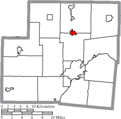
Location of Anna in Shelby County
Coordinates: 40°23′42″N84°10′31″W / 40.39500°N 84.17528°W / 40.39500; -84.17528
Country United States
State Ohio
County Shelby
Government
   Mayor Mark Pulfer
Area
[2]
  Total1.11 sq mi (2.87 km2)
  Land1.11 sq mi (2.87 km2)
  Water0.00 sq mi (0.00 km2)
Elevation
[3]
1,024 ft (312 m)
Population
 (2020)
  Total1,470
  Estimate 
(2023) [4]
1,460
  Density1,326.71/sq mi (512.17/km2)
Time zone UTC-5 (Eastern (EST))
  Summer (DST) UTC-4 (EDT)
ZIP code
45302
Area codes 937, 326
FIPS code 39-02092 [5]
GNIS feature ID2397963 [3]
Website Village website

Anna is a village in Shelby County, Ohio, United States. The population was 1,470 at the 2020 census.

Contents

History

Pre-historical period

The prehistoric Teays River ran through modern-day Anna about 2 million years ago. The Teays river deposited loose sediment on the Greenville fault line which created a major earthquake center.[ citation needed ]

Native American period

According to the Native Americans, Tecumseh tried to start his alliances in what is now Anna. Most native Shawnee and Miami tribes refused the offer. He supposedly put a curse on the land. The curse stated that the land would be ever plagued with the trembling of the earth. [6]

Settlement

The first white settlement at Anna was made in the 1830s. [7] Anna was platted in 1868, and named for Anna Thirkield. The village was incorporated in 1877. [8]

1937 earthquakes

On March 9, 1937, the largest recorded earthquake in Ohio occurred where the high school and middle school now stand. It was measured at 5.4 on the Richter magnitude scale, while damage was at intensity VIII according to the Mercalli intensity scale. [9] The shock was felt as far away as Chicago, Illinois, and Toronto, Ontario. The shaking followed a similar but somewhat weaker event that had happened a week earlier, on March 2. The Lutheran and Methodist Churches were heavily damaged; the Lutheran Church subsequently put metal braces in its attic to protect it from future earthquakes. The partially damaged school became a total loss for the town and had to be rebuilt. The town hall was so badly damaged that the upper story was condemned and has not been used since.

The Shelby County area has experienced at least 40 earthquakes since 1875. [10]

Geography

According to the United States Census Bureau, the village has a total area of 1.03 square miles (2.67 km2), all land. [11]

Industry

Anna is the location of a Honda of America Manufacturing (HAM) Plant that produces engines and other components for a range of Honda vehicles.

Education

Anna Local Schools is located in three separate buildings: elementary in one, middle in one, and high school in one.

Anna has a public library, a branch of Shelby County Libraries. [12]

Demographics

Historical population
CensusPop.Note
1880 266
1890 52798.1%
1900 451−14.4%
1910 4602.0%
1920 4630.7%
1930 462−0.2%
1940 4855.0%
1950 55414.2%
1960 70126.5%
1970 79213.0%
1980 1,03831.1%
1990 1,16412.1%
2000 1,31913.3%
2010 1,56718.8%
2020 1,470−6.2%
2023 (est.)1,460 [4] −0.7%
U.S. Decennial Census [13]

2000 census

As of the census [5] of 2000, there were 1,319 people, 474 households, and 365 families living in the village. The population density was 1,576.7 inhabitants per square mile (608.8/km2). There were 483 housing units at an average density of 577.4 per square mile (222.9/km2). The racial makeup of the village was 96.59% White, 0.38% African American, 0.15% Native American, 1.36% Asian, 0.23% Pacific Islander, 0.23% from other races, and 1.06% from two or more races. Hispanic or Latino people of any race were 0.53% of the population.

There were 474 households, out of which 46.2% had children under the age of 18 living with them, 62.0% were married couples living together, 11.4% had a female householder with no husband present, and 22.8% were non-families. 19.6% of all households were made up of individuals, and 6.3% had someone living alone who was 65 years of age or older. The average household size was 2.78 and the average family size was 3.20.

In the village, the population was spread out, with 32.3% under the age of 18, 7.6% from 18 to 24, 33.5% from 25 to 44, 19.3% from 45 to 64, and 7.4% who were 65 years of age or older. The median age was 31 years. For every 100 females there were 99.8 males. For every 100 females age 18 and over, there were 94.1 males.

The median income for a household in the village was $48,676, and the median income for a family was $51,797. Males had a median income of $36,250 versus $25,463 for females. The per capita income for the village was $19,835. About 3.4% of families and 3.6% of the population were below the poverty line, including 2.7% of those under age 18 and 3.8% of those age 65 or over.

2010 census

As of the census [14] of 2010, there were 1,567 people, 551 households, and 429 families living in the village. The population density was 1,521.4 inhabitants per square mile (587.4/km2). There were 589 housing units at an average density of 571.8 per square mile (220.8/km2). The racial makeup of the village was 97.4% White, 0.4% African American, 0.4% Native American, 0.2% Asian, 0.1% from other races, and 1.5% from two or more races. Hispanic or Latino people of any race were 0.6% of the population.

There were 551 households, of which 47.5% had children under the age of 18 living with them, 57.4% were married couples living together, 13.8% had a female householder with no husband present, 6.7% had a male householder with no wife present, and 22.1% were non-families. 18.0% of all households were made up of individuals, and 6.7% had someone living alone who was 65 years of age or older. The average household size was 2.84 and the average family size was 3.20.

The median age in the village was 31.1 years. 33.4% of residents were under the age of 18; 7.2% were between the ages of 18 and 24; 30.5% were from 25 to 44; 21.9% were from 45 to 64; and 7.1% were 65 years of age or older. The gender makeup of the village was 48.4% male and 51.6% female.

Related Research Articles

<span class="mw-page-title-main">Shelby County, Ohio</span> County in Ohio, United States

Shelby County is a county in the western portion of the U.S. state of Ohio. As of the 2020 United States Census, the population was 48,230. Its county seat is Sidney. Its name honors Isaac Shelby, first governor of Kentucky.

Westwood is a census-designated place in Boyd County, Kentucky, United States. The population was 4,387 at the 2020 census. A suburb of Ashland, the two areas are closely affiliated, sharing a ZIP code and bus system. Westwood is located on a flat to hilly elevation just west of the Ohio River. The flat hilltop is unusual to eastern Kentucky and was created by the preglacial Teays River which existed in ancient times and flowed in the opposite direction of the Ohio River. Westwood is part of the Huntington–Ashland metropolitan area.

<span class="mw-page-title-main">Shelby, Oceana County, Michigan</span> Village in Michigan, United States

Shelby is a village in Oceana County in the U.S. state of Michigan. The population was 2,065 at the 2010 census.

<span class="mw-page-title-main">Minster, Ohio</span> Village in Ohio, United States

Minster is a village in Auglaize and Shelby counties, in the U.S. state of Ohio. The population was 3,046 at the 2020 census. It is included in the Wapakoneta, Ohio Micropolitan Statistical Area. It is adjacent to the village of New Bremen to the north.

<span class="mw-page-title-main">Addyston, Ohio</span> Village in Ohio, United States

Addyston is a village in Miami Township, Hamilton County, Ohio, United States. Located along the Ohio River, it is a western suburb of the neighboring city of Cincinnati. The population was 927 at the 2020 census.

<span class="mw-page-title-main">Cleves, Ohio</span> City in Ohio, United States

Cleves is a village in Miami Township, Hamilton County, Ohio, United States. Located along the Ohio River, it is a western suburb of Cincinnati. The population was 3,414 at the 2020 census.

<span class="mw-page-title-main">Evendale, Ohio</span> Village in Ohio, United States

Evendale is a village in Hamilton County, Ohio, United States, within the Cincinnati metropolitan area. The population was 2,669 at the 2020 census.

<span class="mw-page-title-main">North Bend, Ohio</span> Village in Ohio, United States

North Bend is a village in Miami Township, Hamilton County, Ohio, United States, along the Ohio River. It is a part of the Greater Cincinnati area. The population was 835 at the 2020 census.

<span class="mw-page-title-main">Seville, Ohio</span> Village in Ohio, United States

Seville is a village in Medina County, Ohio, United States. The population was 2,335 at the 2020 census.

<span class="mw-page-title-main">Commercial Point, Ohio</span> Village in Ohio, United States

Commercial Point is a village in Pickaway County, Ohio, United States. The population was 3,078 at the 2020 census. It is the fastest-growing affluent community in Pickaway County and one of the fastest-growing villages in central Ohio. It is a suburb of Columbus, OH

<span class="mw-page-title-main">South Bloomfield, Ohio</span> Village in Ohio, United States

South Bloomfield is a village in Pickaway County, Ohio, United States. The population was 2,143 at the 2020 census. Since the 2000 census, it has consistently been one of the fastest-growing villages in central Ohio.

<span class="mw-page-title-main">Shelby, Ohio</span> City in Ohio, United States

Shelby is a city in Richland County in the U.S. state of Ohio, northwest of the city of Mansfield. It is part of the Mansfield, Ohio Metropolitan Statistical Area. The population was 9,282 as of the 2020 census.

<span class="mw-page-title-main">Botkins, Ohio</span> Village in Ohio, United States

Botkins is a village in Shelby County, Ohio, United States. The population was 1,155 at the 2020 census.

<span class="mw-page-title-main">Fort Loramie, Ohio</span> Village in Ohio, United States

Fort Loramie is a village in Shelby County, Ohio, United States, along Loramie Creek, a tributary of the Great Miami River in southwestern Ohio. It is 42 mi. north-northwest of Dayton and 20 mi. east of the Ohio/Indiana border. The population was 1,590 at the 2020 census. The village was founded in 1837 near the former site of a colonial fort of the same name.

<span class="mw-page-title-main">Jackson Center, Ohio</span> Village in Ohio, United States

Jackson Center is a village in Shelby County, Ohio, United States. The population was 1,441 at the 2020 census.

<span class="mw-page-title-main">Kettlersville, Ohio</span> Village in Ohio, United States

Kettlersville is a village in Shelby County, Ohio, United States. The population was 164 at the 2020 census.

<span class="mw-page-title-main">Lockington, Ohio</span> Village in Ohio, United States

Lockington is a village in Washington Township, Shelby County, Ohio, United States, along Loramie Creek. The population was 162 at the 2020 census.

<span class="mw-page-title-main">Port Jefferson, Ohio</span> Village in Ohio, United States

Port Jefferson is a village in Salem Township, Shelby County, Ohio, United States. The population was 308 at the 2020 census.

<span class="mw-page-title-main">Russia, Ohio</span> Village in Ohio, United States

Russia is a village in Loramie Township, Shelby County, Ohio, United States. The population was 712 at the 2020 census.

<span class="mw-page-title-main">Teays Valley, West Virginia</span> Census-designated place in West Virginia, United States

Teays Valley is a census-designated place in Putnam County, West Virginia, United States. The population was 14,350 at the 2020 census. Located about 20 miles (32 km) west of Charleston and 30 miles (48 km) east of Huntington, it is part of the Huntington–Ashland metropolitan area.

References

  1. "Where is 'Earthquake Capital' Of Ohio?". Dayton Daily News. August 25, 2011. Retrieved May 20, 2024.
  2. "ArcGIS REST Services Directory". United States Census Bureau. Retrieved September 20, 2022.
  3. 1 2 U.S. Geological Survey Geographic Names Information System: Anna, Ohio
  4. 1 2 "Annual Estimates of the Resident Population for Incorporated Places in Ohio: April 1, 2020 to July 1, 2023". United States Census Bureau. Retrieved May 20, 2024.
  5. 1 2 "U.S. Census website". United States Census Bureau . Retrieved January 31, 2008.
  6. "Earthquake". www.anna.k12.oh.us. Retrieved February 12, 2016.
  7. Overman, William Daniel (1958). Ohio Town Names. Akron, OH: Atlantic Press. p. 4.
  8. Hitchcock, Almon Baldwin Carrington (1913). History of Shelby County, Ohio, and representative citizens. p. 340.
  9. USGS, Historic Earthquakes, United States Geological Survey, archived from the original on February 11, 2006
  10. Resources, Ohio Department of Natural. "Ohio Department of Natural Resources". www.dnr.state.oh.us.
  11. "US Gazetteer files 2010". United States Census Bureau. Archived from the original on January 25, 2012. Retrieved January 6, 2013.
  12. "Locations". Shelby County Libraries. Archived from the original on March 13, 2018. Retrieved March 3, 2018.
  13. "Census of Population and Housing". Census.gov. Retrieved June 4, 2015.
  14. "U.S. Census website". United States Census Bureau . Retrieved January 6, 2013.