Kirnberg an der Mank | |
|---|---|
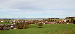 View from south | |
 Coat of arms | |
 Kirnberg an der Mank Location within Austria | |
| Coordinates: 48°4′N15°19′E / 48.067°N 15.317°E | |
| Country | Austria |
| State | Lower Austria |
| District | Melk |
| Government | |
| • Mayor | Ferdinand Neuhauser |
| Area | |
• Total | 17.67 km2 (6.82 sq mi) |
| Elevation | 341 m (1,119 ft) |
| Population (2018-01-01) [2] | |
• Total | 1,070 |
| • Density | 61/km2 (160/sq mi) |
| Time zone | UTC+1 (CET) |
| • Summer (DST) | UTC+2 (CEST) |
| Postal code | 3241 |
| Area code | 02755 |
| Website | www.kirnberg.at |
Kirnberg an der Mank is a town in the district of Melk in the Austrian state of Lower Austria.