Dunkelsteinerwald (municipality)

Last updated
This page is about Dunkelsteinerwald, the municipality. For the region of the same name see Dunkelsteinerwald.
Dunkelsteinerwald
AUT Dunkelsteinerwald COA.png
Austria adm location map.svg
Red pog.svg
Dunkelsteinerwald
Location within Austria
Coordinates: 48°18′24″N15°28′20″E / 48.30667°N 15.47222°E / 48.30667; 15.47222 Coordinates: 48°18′24″N15°28′20″E / 48.30667°N 15.47222°E / 48.30667; 15.47222
Country Austria
State Lower Austria
District Melk
Government
   Mayor Franz Penz (ÖVP)
Area
[1]
  Total54.19 km2 (20.92 sq mi)
Elevation
585 m (1,919 ft)
Population
 (2018-01-01) [2]
  Total2,390
  Density44/km2 (110/sq mi)
Time zone UTC+1 (CET)
  Summer (DST) UTC+2 (CEST)
Postal code
3122
Area code 02753
Vehicle registration ME
Website www.dunkelsteinerwald.at

Dunkelsteinerwald is a market municipality with 2,289 inhabitants in the district Melk in Lower Austria, Austria.

Contents

Mauer bei Melk, Carving altar 1509 Mauer - Kirche, Schnitzaltar.JPG
Mauer bei Melk, Carving altar 1509

Geography

Dunkelsteinerwald lies in the Mostviertel in Lower Austria. The surface of the market municipality covers 54.19 square kilometers. 46.73 percent of the area is wooded.

The municipality includes the cadastral districts of Eckartsberg, Gansbach, Gerolding, Geroldinger Wald, Häusling, Heitzing, Hessendorf, Himberg, Hohenwarth, Kicking, Kochholz, Krapfenberg, Lanzing, Lerchfeld, Lottersberg, Mauer bei Melk, Neuhofen, Nölling, Ohnreith, Pfaffing, Thal, Umbach und Ursprung.

History

In the antiquity the area was part of the Roman province of Noricum. Lying in the Austrian heartland of Lower Austria, the place took part in the eventful history of Austria.
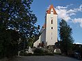
Mauer bei Melk Panorama Mauer.jpg
Mauer bei Melk

Inhabitant development

After the result of the census of 2001, there were 2289 inhabitants. In 1991, the market municipality had 2025 inhabitants, up from 1941 in 1981 and 1911 in 1971.

Politics

The mayor of the market municipality is Franz Penz from the christ-democratic ÖVP, the office manager Erich Galander. The 21 seats in the municipal council are currently assigned to the following parties: SPÖ 5, GREENs 1, ÖVP 15.

Culture and sights

Buildings

Related Research Articles

Melk Place in Lower Austria, Austria

Melk is a city of Austria, in the federal state of Lower Austria, next to the Wachau valley along the Danube. Melk has a population of 5,257. It is best known as the site of a massive baroque Benedictine monastery named Melk Abbey.

Dunkelsteinerwald

The Dunkelsteinerwald is a hill country south of the Danube in the Mostviertel region of Lower Austria. It is located at the shore of the Danube between Melk and Mautern, south of Krems.

Mauer bei Melk Village in Melk District, Austria

Mauer is a village in the municipality of Dunkelsteinerwald, in the Mostviertel in Lower Austria, Austria.

Schwaz Place in Tyrol, Austria

Schwaz is a city in the Austrian state of Tyrol. It is the administrative center of the Schwaz district. Schwaz is located in the lower Inn valley.

Gmünd, Carinthia Place in Carinthia, Austria

Gmünd in Kärnten is a municipality and historic town in the district of Spittal an der Drau, in the Austrian state of Carinthia.

Maria Taferl Place in Lower Austria, Austria

Maria Taferl is an Austrian market municipality of 872 people in the District of Melk and the most important pilgrimage site in all of Lower Austria. After Mariazell, Maria Taferl is the most important pilgrimage destination in all of Austria.

Straßburg, Austria Place in Carinthia, Austria

Straßburg is a town in the district of Sankt Veit an der Glan in Carinthia, Austria.

Kötschach-Mauthen Place in Carinthia, Austria

Kötschach-Mauthen is a market town in the district of Hermagor in Carinthia in Austria.

Obervellach Place in Carinthia, Austria

Obervellach is a market town in the district of Spittal an der Drau, in the Austrian state of Carinthia.

Bad Sankt Leonhard im Lavanttal Place in Carinthia, Austria

Bad Sankt Leonhard im Lavanttal is a spa town in the district of Wolfsberg in the Austrian state of Carinthia.

Hauskirchen Place in Lower Austria, Austria

Hauskirchen is a town in the district of Gänserndorf in the Austrian state of Lower Austria.

Neumarkt an der Ybbs is a town in the district of Melk in the Austrian state of Lower Austria.

Lavant, Tyrol Place in Tyrol, Austria

Lavant is a municipality in the district of Lienz in the upper Drautal valley in East Tyrol, Austria. It is located southeast of the city of Lienz.

Weißpriach Place in Salzburg, Austria

Weißpriach is a municipality in the district of Tamsweg in the state of Salzburg in Austria. It is located in a valley of the Niedere Tauern mountain range.

Langenrohr Place in Lower Austria, Austria

Langenrohr is a municipality in the district of Tulln in Lower Austria, Austria. The municipality has 2309 inhabitants as of 1 January 2013.

Gerasdorf bei Wien Place in Lower Austria, Austria

Gerasdorf bei Wien is a town in the district of Korneuburg in the Austrian state of Lower Austria. The city has 10,862 inhabitants.

Aschach an der Donau Place in Upper Austria, Austria

Aschach an der Donau is a municipality in the district Eferding in the Austrian state of Upper Austria.

Vorchdorf Place in Upper Austria, Austria

Vorchdorf is a market town in the district of Gmunden in Upper Austria, Austria, as well as the name of the municipal area ("Gemeinde") that the town and others occupy. As of the 2005 census, the town of Vorchdorf had a population of 7,287 inhabitants.

Hengsberg is a municipality in the district of Leibnitz in Styria, in southeast Austria.

Gansbach

Gansbach is a small town and centre of the municipality of Dunkelsteinerwald in Melk District, Lower Austria in northeastern Austria. It lies several kilometres inland from the Danube. To the west and north of the settlement is the Wachau valley. The parish church probably originates from the 14th century. The side altar piece of the famous painter Kremser Schmidt and the high altarpiece, which was painted by one of his students are of note.

References

  1. "Dauersiedlungsraum der Gemeinden Politischen Bezirke und Bundesländer - Gebietsstand 1.1.2018". Statistics Austria. Retrieved 10 March 2019.
  2. "Einwohnerzahl 1.1.2018 nach Gemeinden mit Status, Gebietsstand 1.1.2018". Statistics Austria. Retrieved 9 March 2019.